Agaete
| Agaete | |
|---|---|
| Municipality | |
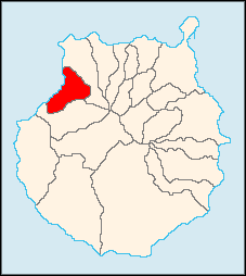 Municipal location in Gran Canaria | |
 Agaete Location in the Canary Islands | |
| Coordinates: 28°6′N 15°42′W / 28.100°N 15.700°WCoordinates: 28°6′N 15°42′W / 28.100°N 15.700°W | |
| Country |
|
| Autonomous Region | Canary Islands |
| Province | Las Palmas |
| Island | Gran Canaria |
| Area[1] | |
| • Total | 45.50 km2 (17.57 sq mi) |
| Elevation | 43 m (141 ft) |
| Population (2013)[2] | |
| • Total | 5,796 |
| • Density | 130/km2 (330/sq mi) |
| Time zone | GMT (UTC+0) |
| Climate | BWh |
| Website | Ayuntamiento de Agaete |
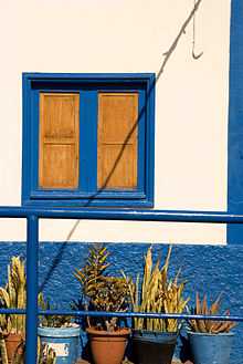
Architecture of Agaete, Gran Canaria
Agaete is a municipality of Las Palmas province, on the Canary Islands, Spain. It is in the northwest of Gran Canaria island, enclosed by the Atlantic Ocean to the west, Gáldar to the northeast, and Artenara to the south. Agaete's area is 45,50 km²[1] with a population of 5,796 (2003[2]).
Agaete used to be the preferred place to get a view of El Dedo de Dios, a natural monument on the coastline, before the latter was destroyed during Tropical Storm Delta in November 2005.
Historical population
| Year | Population |
|---|---|
| 1991 | 5,269 |
| 1996 | 6,028 |
| 2001 | 5,202 |
| 2002 | 5,649 |
| 2003 | 5,635 |
| 2004 | 5,511 |
| 2013 | 5,796 |
See also
References
- ↑ 1.0 1.1 Instituto Canario de Estadística, area
- ↑ 2.0 2.1 Instituto Canario de Estadística, population
External links
- Ayuntamiento de Agaete
- Photos of Agaete, including Puerto de Las Nieves and the valley, "El Valle"
| ||||||||||||||||