Afon Pyrddin
The Afon Pyrddin is a river forming the boundary between the county of Powys and the county borough of Neath Port Talbot in south Wales, Great Britain. It also forms a part of the boundary of the Brecon Beacons National Park. The river and its waterfalls are one of the key attractions of the recently designated Fforest Fawr Geopark.
The name could be a reference to Saint David, the patron saint of Wales – purddyn meaning "pure man" in Welsh – although the likelihood of this has been disputed.[1]
The streams of Nant y Bryn, Nant y Fedwen and Nant Hir come together to form the Pyrddin which flows south-eastwards for 5 km / 3 mi to its confluence with the Nedd Fechan.[2]
Waterfalls
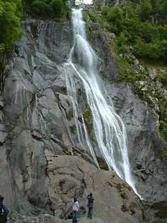
The Pyrddin is best known for two spectacular waterfalls, Sgwd Gwladus and Sgwd Einion Gam, the lady's fall and the fall of crooked Einion respectively. Sgwd Gwladus is formed where a band of erosion-resistant gritstone known as the 'Twelve Foot Sandstone' creates a lip over which the river plunges. It is easily accessible by footpath from Pontneddfechan. A notable feature beside the fall is the erratic block of gritstone which was balanced so that it rocked - at least until Victorian times when it was displaced. The ruins of a small building close to the falls are thought to be those of a corn-mill.
Sgwd Einion Gam, which is a further half mile, upstream can be accessed only by crossing and re-crossing the river itself. This fall is caused by the presence of a geological fault which brings another hard sandstone known as the 'Farewell Rock' up against softer mudstones.[3][4]
Habitat protection
The steep and wooded gorge of the Pyrddin – like that of its neighbours, the Nedd Fechan, Afon Mellte, and Afon Hepste – is home to many rare bryophytes which enjoy the cool humid conditions which exist here. Accordingly it has been designated as both a site of special scientific interest and a special area of conservation.[5]
References
- ↑ Some Place Names in South Wales
- ↑ Ordnance Survey Explorer map sheet OL12 'Brecon Beacons National Park: western area'
- ↑ Brecon Beacons National Park website
- ↑ British Geological Survey 1:50,000 map no. 231 'Merthyr Tydfil' & accompanying memoir
- ↑ Countryside Council for Wales website
External links
Coordinates: 51°46′N 3°36′W / 51.767°N 3.600°W
| ||||||||||||||||||||