Afar Triangle
Coordinates: 11°30′N 41°00′E / 11.5°N 41.0°E

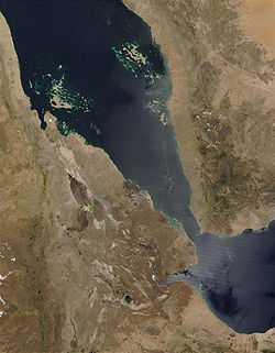
The Afar Triangle (also called the Afar Depression) is a geological depression that is caused by the Afar Triple Junction, which is part of the Great Rift Valley. It overlaps Eritrea, Djibouti and the entire Afar Region of Ethiopia. The depression is bordered by the Ethiopian Plateau and escarpment to the west, by the Danakil block to the north-east (between it and the Red Sea), by the Somalian Plateau and escarpment to the south, and by the Ali-Sabieh block (adjoining the Somalian Plateau) to the south-east.[1][2]
The Afar Triangle includes the lowest point in Africa, Lake Asal (155 metres or 509 feet below sea level) in Djibouti. The Awash River is the main waterflow into the area, where it ends in a chain of lakes that increase in salinity. The northern part of the Afar Triangle is also known as the Danakil Depression.[2]
Dallol in the Danakil Depression is one of the hottest places year-round anywhere on Earth. The climate varies from around 25 °C (77 °F) during the rainy season (September–March) to 48 °C (118 °F) during the dry season (March–September).
The Afar Triangle is well known as one of the cradles of extinct hominids. It contains the Middle Awash, site of many fossil hominid discoveries, such as Ardi (Ardipithecus ramidus); the Gona (Gawis cranium), site of the world's oldest stone tools; and Hadar, site of Lucy, the fossilized specimen of Australopithecus afarensis.
Environment
The lowlands of the Afar Depression are affected by heat and drought. There is no rain for most of the year, and yearly rainfall averages range from 100 to 200 millimetres (4 to 7 in), with less rain falling closer to the coast.
The Awash River, flowing north-eastward through the southern part of the Afar Region, provides a narrow green belt and enables life for the flora and fauna in the area and for the Afars, the nomadic people living in the Danakil desert. About 128 kilometres (80 mi) from the Red Sea, the Awash ends in a chain of salt lakes, where its water evaporates as quickly as it is supplied. About 1,200 km2 (460 sq mi) of the Afar Depression is covered by salt, and salt mining is still a major source of income for many Afar groups.
The Afar Depression biome is characterized as desert scrubland. Vegetation is mostly confined to drought-resistant plants such as small trees (e.g. species of the dragon tree), shrubs, and grasses. Wildlife includes many herbivores such as Grevy's Zebra, Soemmering’s Gazelle, Oryx Beisa and, notably, the last viable population of African wild ass (Equus africanus somalicus).
Birds include the ostrich, the endemic Archer's lark (Heteromirafra archeri), the Secretary Bird, Arabian and Kori bustards, Abyssinian Roller and Crested Francolin. In the southern part of the plain, in Ethiopia, lies the Mille-Sardo Wildlife Reserve (established 1973). Many important fossil localities occur in the Afar region. These include the Middle Awash region and the sites of Hadar, Dikika, and Woranso-Mille. These sites have produced not only hominins, but also fossils of a variety of other mammals.
Geology

The Afar Depression is the product of a tectonic triple junction (the Afar Triple Junction), where the spreading ridges that form the Red Sea and the Gulf of Aden emerge on land and meet the East African Rift. The central meeting place for these three pieces of Earth's crust is around Lake Abbe. The Afar Depression is one of two places on Earth where a mid-ocean ridge can be studied on land, the other being Iceland.
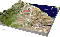
In the Depression, the Earth's crust is slowly rifting apart at a rate of 1–2 centimetres (0.4–0.8 in) per year along each of the three rifts which form the "legs" of the triple junction. The immediate consequence of this is that there are (as of late 2005) a continuous sequence of earthquakes, fissures hundreds of metres long and deep appearing in the ground, and the valley floor sinking as much as 100 metres. Between September and October 2005, 163 earthquakes of magnitudes greater than 3.9 and a volcanic eruption occurred within the Afar rift at the Dabbahu and Erta Ale volcanoes. 2.5 cubic kilometers of molten rock was injected into the plate along a dyke between depths of 2 and 9 km, forcing open an 8 meter wide gap on the surface, known as the Dabbahu fissure.[3][4]

Related eruptions have taken place in Teru and Aura woredas. The rift has recently been recorded by means of three-dimensional laser mapping.[5]
The salt deposits which local people mine for income were created, over the course of history, as water from the Red Sea periodically flooded the Depression and evaporated; the most recent such flood was roughly 30,000 years ago.[6] Over millions of years, geologists expect the Red Sea to erode through the highlands surrounding the Afar Depression and flood the valley. In about 10 million years, geologists predict that the whole 6,000 km length of the East African Rift will be submerged, forming a new sea as large as the Red Sea is now, and separating the Horn of Africa from the rest of the continent.[7]
The floor of the Afar Depression is composed of lava, mostly basalt. One of Earth's five lava lakes, Erta Ale is found here, as well as Dabbahu Volcano. It has been proposed that the Afar Depression is underlain by a mantle plume,[8] a great upwelling of mantle that melts to yield basalt as it approaches the surface.
See also
- Horst
- Lake Assal in Djibouti
- List of fossil sites (with link directory)
- List of hominina (hominid) fossils (with images)
- The Afar people who inhabit the region
References
Notes
- ↑ "Geology of the Afar Depression". Afar Rift Consortium. Retrieved 27 October 2013.
- ↑ 2.0 2.1 Beyene, Alebachew & Abdelsalam, Mohamed G. (2005). "Tectonics of the Afar Depression: A review and synthesis". Journal of African Earth Sciences 41 (1–2): 41–59. doi:10.1016/j.jafrearsci.2005.03.003.
- ↑ Wright, TJ; Ebinger, C; Biggs, J; Ayele, A; Yirgu, G; Keir, D; Stork, A (July 2006). "Magma-maintained rift segmentation at continental rupture in the 2005 Afar dyking episode". Nature 442 (7100): 291–294. doi:10.1038/nature04978. PMID 16855588.
- ↑ "Inside the Hottest Place on Earth". BBC News. 2009-03-19. Retrieved August 30, 2009.
- ↑ Hottest Place On Earth, Episode 1 at bbc.co.uk
- ↑ Morell, Virginia (January 2012). "Hyperactive Zone". National Geographic 221 (1): 116–127.
- ↑ Bojanowski 2006
- ↑ Hammond, J. O. S., J.- M. Kendall, G. W. Stuart, C. J. Ebinger, I. D. Bastow, D. Keir, A. Ayele, M. Belachew, B. Goitom, G. Ogubazghi, and T. J. Wright. "Mantle Upwelling and Initiation of Rift Segmentation beneath the Afar Depression." Geology 41.6 (2013): 635-38. DOI:10.1130/G33925.1
Bibliography
- Barberi, F.; Borsi, S.; Ferrara, G.; Marinelli, G.; Santacroce, R.; Tazieff, H.; Varet, J. (1972). "Evolution of the Danakil Depression (Afar, Ethiopia) in Light of Radiometric Age Determinations". Journal of Geology 80 (6): 720–729. doi:10.1086/627797.
- Bojanowski, Axel (2006-03-15). "Africa's New Ocean: A Continent Splits Apart". Spiegel Online. Retrieved 2006-03-16. Includes a photo essay of the region and its geologic changes.
- Kloos, Helmut (1982). "Development, drought and famine in the Awash valley of Ethiopia". African Studies Review 25 (4): 21–48. doi:10.2307/524399. JSTOR 524399.
- "Ethiopian xeric grasslands and shrublands". Terrestrial Ecoregions. World Wildlife Fund.
- Jon Kalb: Adventures in the Bone Trade. The Race to Discover Human Ancestors in Ethiopia's Afar Depression. Copernicus Books, New York 2001, ISBN 0-387-98742-8
- Jeangene Vilmer, Jean-Baptiste; Gouery, Franck (2011 ISBN 9782352701088). Les Afars d'Éthiopie. Dans l'enfer du Danakil. Check date values in:
|date=(help)
External links
| Wikimedia Commons has media related to Great Rift Valley. |
- The Ethiopian state of Afar: Topography and Climate
- (French) Photos of Afars and Danakil
- (French) Photos of Erta Ale, Hotsprings at Dallol and Danakil
- (German) Huge collection of (3000) photos from different expeditions in the Dallol, Erta Ale and Danakil regions
- (French) Photos of Afar Depression: between Ethiopia and Djibouti
- (English) Web site of Main Ethiopian Rift
- Science news: Death of a Continent, Birth of an Ocean