Admire, Kansas
| Admire, Kansas | |
|---|---|
| City | |
|
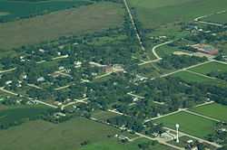
Aerial view of Admire, Kansas | |
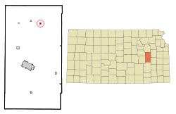 Location of Admire, Kansas | |
| Coordinates: 38°38′29″N 96°6′7″W / 38.64139°N 96.10194°WCoordinates: 38°38′29″N 96°6′7″W / 38.64139°N 96.10194°W | |
| Country | United States |
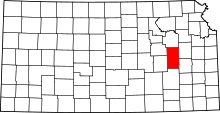
| State | Kansas |
| County | Lyon |
| Government[1] | |
| • Type | Mayor/Council |
| • Mayor | Michael Spade |
| • City Clerk | Wendy Linsey |
| Area[2] | |
| • Total | 0.33 sq mi (0.85 km2) |
| • Land | 0.33 sq mi (0.85 km2) |
| • Water | 0 sq mi (0 km2) |
| Elevation | 1,237 ft (377 m) |
| Population (2010)[3] | |
| • Total | 156 |
| • Estimate (2012[4]) | 156 |
| • Density | 472.7/sq mi (182.5/km2) |
| Time zone | Central (CST) (UTC-6) |
| • Summer (DST) | CDT (UTC-5) |
| ZIP code | 66830 |
| Area code(s) | 620 |
| FIPS code | 20-00325[5] |
| GNIS feature ID | 0477042[6] |
Admire is a city in Lyon County, Kansas, United States. As of the 2010 census, the city population was 156.[7] It is part of the Emporia Micropolitan Statistical Area.
History
Admire was founded in 1886.[8] It was named for one of its founders, Jacob Admire.[9]
The first post office in Admire was established in November 1886.[10]
Admire was a station and shipping point on the Missouri Pacific Railroad.[11] By the 1980s, rail service in Admire had been discontinued, and the tracks are now being used as a rail trail.[12]
Geography
Admire is located at 38°38′29″N 96°6′7″W / 38.64139°N 96.10194°W (38.641416, -96.101932).[13] According to the United States Census Bureau, the city has a total area of 0.33 square miles (0.85 km2), all land.[2]
Demographics
| Historical population | |||
|---|---|---|---|
| Census | Pop. | %± | |
| 1990 | 147 | — | |
| 2000 | 177 | 20.4% | |
| 2010 | 156 | −11.9% | |
| U.S. Decennial Census | |||
2010 census
As of the census[3] of 2010, there were 156 people, 60 households, and 43 families residing in the city. The population density was 472.7 inhabitants per square mile (182.5/km2). There were 70 housing units at an average density of 212.1 per square mile (81.9/km2). The racial makeup of the city was 95.5% White, 0.6% from other races, and 3.8% from two or more races. Hispanic or Latino of any race were 7.1% of the population.
There were 60 households of which 33.3% had children under the age of 18 living with them, 60.0% were married couples living together, 8.3% had a female householder with no husband present, 3.3% had a male householder with no wife present, and 28.3% were non-families. 28.3% of all households were made up of individuals and 15% had someone living alone who was 65 years of age or older. The average household size was 2.60 and the average family size was 3.16.
The median age in the city was 32.5 years. 26.3% of residents were under the age of 18; 9% were between the ages of 18 and 24; 23.1% were from 25 to 44; 25.7% were from 45 to 64; and 16% were 65 years of age or older. The gender makeup of the city was 47.4% male and 52.6% female.
2000 census
As of the census[5] of 2000, there were 177 people, 67 households, and 47 families residing in the city. The population density was 534.5 people per square mile (207.1/km²). There were 73 housing units at an average density of 220.4 per square mile (85.4/km²). The racial makeup of the city was 95.48% White, 0.56% Native American, 0.56% from other races, and 3.39% from two or more races. 1.13% of the population were Hispanic or Latino of any race.
There were 67 households out of which 37.3% had children under the age of 18 living with them, 62.7% were married couples living together, 6.0% had a female householder with no husband present, and 28.4% were non-families. 26.9% of all households were made up of individuals and 11.9% had someone living alone who was 65 years of age or older. The average household size was 2.64 and the average family size was 3.17.
In the city the population was spread out with 28.2% under the age of 18, 11.3% from 18 to 24, 29.4% from 25 to 44, 20.9% from 45 to 64, and 10.2% who were 65 years of age or older. The median age was 34 years. For every 100 females there were 90.3 males. For every 100 females age 18 and over, there were 92.4 males.
The median income for a household in the city was $40,250, and the median income for a family was $47,250. Males had a median income of $26,406 versus $18,750 for females. The per capita income for the city was $15,666. About 3.9% of families and 4.4% of the population were below the poverty line, including 4.9% of those under the age of eighteen and none of those sixty five or over.
References
- ↑ http://www.lkm.org/directory/cities.php?ID=502
- ↑ 2.0 2.1 "US Gazetteer files 2010". United States Census Bureau. Retrieved 2012-07-06.
- ↑ 3.0 3.1 "American FactFinder". United States Census Bureau. Retrieved 2012-07-06.
- ↑ "Population Estimates". United States Census Bureau. Retrieved 2013-05-29.
- ↑ 5.0 5.1 "American FactFinder". United States Census Bureau. Retrieved 2008-01-31.
- ↑ "US Board on Geographic Names". United States Geological Survey. 2007-10-25. Retrieved 2008-01-31.
- ↑ "2010 City Population and Housing Occupancy Status". U.S. Census Bureau. Retrieved November 27, 2011.
- ↑ Kansas State Historical Society (1916). Biennial Report of the Board of Directors of the Kansas State Historical Society. Kansas State Printing Plant. p. 228.
- ↑ French, Laura M. (1929). History of Emporia and Lyon County, Kansas. Heritage Books. p. 140.
- ↑ "Kansas Post Offices, 1828-1961". Kansas Historical Society. Retrieved 10 June 2014.
- ↑ Blackmar, Frank Wilson (1912). Kansas: A Cyclopedia of State History, Embracing Events, Institutions, Industries, Counties, Cities, Towns, Prominent Persons, Etc. Standard Publishing Company. p. 26.
- ↑ "Kansas' Flint Hills Nature Trail". Rails-to-Trails Conservancy. Retrieved 27 March 2014.
- ↑ "US Gazetteer files: 2010, 2000, and 1990". United States Census Bureau. 2011-02-12. Retrieved 2011-04-23.
External links
| Wikimedia Commons has media related to Admire, Kansas. |
- City
- Schools
- USD 251, local school district
- Maps
- Admire City Map, KDOT
- Lyon County Map, KDOT
| |||||||||||||||||||||