Administrative divisions of India
Republic of India
|
|---|
 |
| This article is part of a series on the politics and government of India |
Parliament:
Judiciary: |
|
Political parties |
|
State and Local gov.
State level: District level:
City level:
Village level:
|
|
Government of India portal |
The Administrative divisions of India are Indian subnational administrative units; they compose a nested hierarchy of country subdivisions. Indian states and territories frequently use different local titles for the same level of subdivision (e.g., the Mandals of Andhra Pradesh correspond to Tehsils of Uttar Pradesh and other Hindi-speaking states and Talukas of Gujarat, Goa, Karnataka, Kerala, Maharashtra, and Tamil Nadu).[1]
The smaller subdivisions (villages and blocks) exist only in rural areas. In urban areas Urban Local Bodies exist instead of these rural subdivisions.
Zones
The States have been grouped into six zones having an Advisory Council to develop the habit of cooperative working” among these States. Five Zonal Councils were set up vide Part-III of the States Reorganisation Act, 1956. The North Eastern States' special problems are addressed by another statutory body - The North Eastern Council, created by the North Eastern Council Act,1971.[2] The present composition of each of these Zonal Councils is as under:[3]
The Northern Zonal Council, comprising the States of Haryana, Himachal Pradesh, Jammu and Kashmir, Punjab, Rajasthan and the Union Territory of Chandigarh;
The North-Central Zonal Council, comprising the States of Bihar, Madhya Pradesh, Uttar Pradesh, Uttarakhand and National Capital Territory of Delhi;
The North-Eastern Zonal Council, comprising the states of Assam, Arunachal Pradesh, Manipur, Meghalaya, Mizoram, Nagaland and Tripura;
The Eastern Zonal Council, comprising the States of Chhattisgarh, Jharkhand, Odisha, Sikkim, West Bengal and the Union Territory of Andaman and Nicobar Islands
The Western Zonal Council, comprising the States of Goa, Gujarat, Maharashtra and the Union Territories of Dadra and Nagar Haveli and Daman and Diu;
The Southern Zonal Council, comprising the States of Andhra Pradesh, Karnataka, Kerala, Tamil Nadu, Telangana and the Union Territories Lakshadweep and Puducherry.
States and union territories
India is composed of 29 states and 7 union territories (including a national capital territory).[4] The union territories are governed by administrators, appointed by the President of India. Two of the territories (Delhi and Puducherry) have been given partial statehood, with elected legislatures and executive councils of ministers, but limited powers.
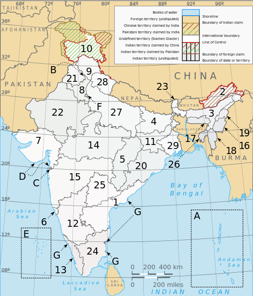
- States
| Number | State | Code | Capital |
|---|---|---|---|
| 1 | Andhra Pradesh | AP | Hyderabad (shared with Telangana for 10 years), Vijayawada [5] announced as capital after 10 years |
| 2 | Arunachal Pradesh | AR | Itanagar |
| 3 | Assam | AS | Dispur |
| 4 | Bihar | BR | Patna |
| 5 | Chhattisgarh | CG | Raipur (interim) |
| 6 | Goa | GA | Panaji |
| 7 | Gujarat | GJ | Gandhinagar |
| 8 | Haryana | HR | Chandigarh (shared with Punjab, also a Union Territory) |
| 9 | Himachal Pradesh | HP | Shimla |
| 10 | Jammu and Kashmir | JK | Srinagar (summer), Jammu (winter) |
| 11 | Jharkhand | JH | Ranchi |
| 12 | Karnataka | KA | Bengaluru |
| 13 | Kerala | KL | Thiruvananthapuram |
| 14 | Madhya Pradesh | MP | Bhopal |
| 15 | Maharashtra | MH | Mumbai |
| 16 | Manipur | MN | Imphal |
| 17 | Meghalaya | ML | Shillong |
| 18 | Mizoram | MZ | Aizawl |
| 19 | Nagaland | NL | Kohima |
| 20 | Odisha | OD | Bhubaneshwar |
| 21 | Punjab | PB | Chandigarh (shared with Haryana, also a Union Territory) |
| 22 | Rajasthan | RJ | Jaipur |
| 23 | Sikkim | SK | Gangtok |
| 24 | Tamil Nadu | TN | Chennai |
| 25 | Telangana[6] | TS | Hyderabad |
| 26 | Tripura | TR | Agartala |
| 27 | Uttar Pradesh | UP | Lucknow |
| 28 | Uttarakhand | UK | Dehradun (interim) |
| 29 | West Bengal | WB | Kolkata |
- Union territories
| Number | Union territory | Code | Capital |
|---|---|---|---|
| A | Andaman and Nicobar Islands | AN | Port Blair |
| B | Chandigarh | CH | Chandigarh (also the capital of Haryana and Punjab) |
| C | Dadra and Nagar Haveli | DN | Silvassa |
| D | Daman and Diu | DD | Daman |
| E | Lakshadweep | LD | Kavaratti |
| F | National Capital Territory of Delhi | DL | New Delhi |
| G | Puducherry | PY | Pondicherry |
- See also:
- List of states and union territories of India by population (area can also be found)
- Official languages of India#Languages currently used In Indian states and union territories
Regions
Some of the states of India are divided into regions. The Regions of India are not official administrative divisions. They have no official administrative governmental status. They are purely geographic regions; some correspond to historic countries, states or provinces. A region may comprise one or more divisions, averaging about three divisions per region. However, the boundaries of the regions and the boundaries of the divisions do not always coincide exactly. So far there has been no movement to give the regions official administrative status. If this was to be done, it would presumably require that the boundaries of the regions be slightly modified so that they correspond exactly with their constituent districts.
- Punjab Region
- Regions of Assam
- Regions of Gujarat
- Regions of Maharashtra
Divisions
Some of the Indian states are subdivided into divisions, each comprising several districts:
- Divisions of Assam
- Divisions of Bihar
- Divisions of Haryana
- Divisions of Jharkhand
- Divisions of Karnataka
- Divisions of Madhya Pradesh
- Divisions of Maharashtra
- Divisions of Punjab
- Divisions of Rajasthan
- Divisions of Uttar Pradesh
- Divisions of Uttarakhand
- Divisions of West Bengal
Districts
States and territories (or divisions) are further subdivided into Districts (zilla), of which there are 655.[7]
Sub-districts
Tehsils, talukas, blocks or mandals (sub-districts but can also refer to division), headed by a Tehsildar or Talukdar, comprise several villages or village clusters. The governmental bodies at the Tehsil level are called the panchayat samiti.
States use varying names for their sub-districts. Detailed information is as follows:[8]
| State | Sub–district | Number of sub–districts |
|---|---|---|
| Andhra Pradesh | Mandal | 661 |
| Arunachal Pradesh | Circle | 149 |
| Assam | Circle | 155 |
| Bihar | C.D.Block | 533 |
| Chhattisgarh | Tehsil | 97 |
| Goa | Taluka | 12 |
| Gujarat | Taluka | 226 |
| Haryana | Tehsil | 67 |
| Himachal Pradesh | Tehsil | 109 |
| Jammu and Kashmir | Tehsil | 59 |
| Jharkhand | C.D.Block | 210 |
| Karnataka | Taluka | 175 |
| Kerala | Taluka | 63 |
| Madhya Pradesh | Tehsil | 259 |
| Maharashtra | Taluka | 353 |
| Manipur | Sub-Division | 38 |
| Meghalaya | C.D.Block | 39 |
| Mizoram | C.D.Block | 22 |
| Nagaland | Circle | 93 |
| Odisha | Police Station | 485 |
| Punjab | Tehsil | 72 |
| Rajasthan | Tehsil | 241 |
| Sikkim | Sub-Division | 9 |
| Tamil Nadu | Taluka | 201 |
| Telangana | Mandal | 452 |
| Tripura | C.D.Block | 38 |
| Uttar Pradesh | Tehsil | 305 |
| Uttarakhand | Tehsil | 49 |
| West Bengal | C.D.Block | 341 |
| Union Territory | Sub–district | Number of sub–districts |
|---|---|---|
| Andaman and Nicobar Islands | Tehsil | 7 |
| Chandigarh | Tehsil | 1 |
| Dadra and Nagar Haveli | Taluka | 1 |
| Daman and Diu | Taluka | 2 |
| Delhi | Tehsil | 27 |
| Lakshadweep | Sub-Division | 4 |
| Puducherry | Commune Panchayat | 10 |
Local level
Blocks
The block is often the next level of administrative division after the tehsil.
Hoblis
A hobli is a subdivision of a taluka which groups adjoining villages in the state of Karnataka. They may have been made for administrative purposes by the revenue department of the state.
Villages
Villages are often the lowest level of subdivisions in India. The governmental bodies at the village level are called Gram Panchayat, of which there were an estimated 256,000 in 2002. Each Gram Panchayat covers a large village or a cluster of smaller villages with a combined population exceeding 500 Gram Sabha. Clusters of villages are also sometimes called Hobli or Patti.
Habitations
Certain governmental functions and activities - including clean water availability, rural development, and education - are tracked at a sub-village level.[9] These hamlets are termed "habitations". India is composed of approximately 1.6 million habitations.[10] In some states, most villages have a single habitation; in others (notably Kerala and Tripura) there is a high ratio of habitations to villages.[11]
Metropolitan
The metropolitan cities of India are: Mumbai, New Delhi, Kolkata, Chennai, Hyderabad and Bangalore.
Corporations
Corporations in India are classified as tier 2 cities like Nagapur, Kanpur, Vizag and others
Municipalities
Municipalities are tier 3 and tier 4 cities, Municipalities of India are governed by Municipal Corporations (Nagar Nigam) for large urban areas, Municipal Councils (Nagar Palika) for smaller urban areas, and Town Councils (Nagar Panchayat) for suburban areas. Municipalities can be as large as a district or smaller than a Tehsil.
Historic
See also
- Autonomous regions of India
- Indian states rankings
- Local Governance in India
- Cultural Zones of India
References
- ↑ http://www.socialjustice.nic.in/pdf/tab11.pdf
- ↑ http://necouncil.nic.in/
- ↑ http://interstatecouncil.nic.in/zonal.htm
- ↑ States and Union Territories of India - Source - Government of India Official Website
- ↑ http://www.deccanchronicle.com/140905/nation-current-affairs/article/vijayawada-andhra-pradesh-new-capital
- ↑ "Appointed Day for Telangana State".
- ↑ "National Panchayat Directory". Ministry of Panchayati Raj. Retrieved 29 May 2012.
- ↑ "Statement showing the Nomenclature and Number of Sub-Districts in States/UTs". Office of The Registrar General & Census Commissioner, India, New Delhi. 2010–2011. Retrieved 2011-10-03.
- ↑ Indian Department of Drinking Water Supply
- ↑ Indian Department of Drinking Water Supply
- ↑ Indian Department of Education
External links
- Explore places from India hierarchically leading to local information and geographic location on map
- Citymayors.com
- Example of district with different subdivisions
| ||||||||||||||
| ||||||||||||||
| ||||||||||||||||||||||||||
| ||||||||||||||||||||||||||||||||||||||||||||||||||||||||||||||||||||||||||||||||||||||||||||||||||||||||||||||||||||
| ||||||||||||||