Adelaide, Eastern Cape
| Adelaide | |
|---|---|
|
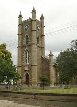
Dutch Reformed Church in Adelaide | |
 Adelaide
| |
| Coordinates: 32°42′S 26°18′E / 32.700°S 26.300°ECoordinates: 32°42′S 26°18′E / 32.700°S 26.300°E | |
| Country | South Africa |
| Province | Eastern Cape |
| District | Amathole |
| Municipality | Nxuba |
| Established | 1834 |
| Area[1] | |
| • Total | 40.0 km2 (15.4 sq mi) |
| Elevation | 600 m (2,000 ft) |
| Population (2011)[1] | |
| • Total | 12,191 |
| • Density | 300/km2 (790/sq mi) |
| Racial makeup (2011)[1] | |
| • Black African | 76.5% |
| • Coloured | 18.8% |
| • Indian/Asian | 0.5% |
| • White | 3.5% |
| • Other | 0.8% |
| First languages (2011)[1] | |
| • Xhosa | 72.3% |
| • Afrikaans | 22.6% |
| • English | 3.0% |
| • Other | 2.1% |
| Postal code (street) | 5760 |
| PO box | 5760 |
| Area code | 046 |
Adelaide is a town and area in the Eastern Cape Province of South Africa. Adelaide is situated near the Great Winterberg Mountain range. Adelaide is an important center of wool sheep farming. Beef, mutton, venison and citrus fruit are also important products.
History
Before European arrival
The modern day area of Adelaide was first inhabited by Bushmen, later on with the arrival of the Xhosa and the settlers, the Bushmen were displaced and are no longer found in the area.
Colonial Adelaide
Adelaide's origins date back to 1835 when a British officer named Captain Alexander Boswell Armstrong (1787–1862) established a military encampment which he named Fort Adelaide after the wife of King William IV. Despite the earlier English settlers, who were part of the 1820 Settlers, later on a large number of both Scottish and Afrikaans people soon immigrated here too. The Scottish were also the first to erect a church in the local area.
References
| |||||||||||||||||||||||||||||||||||||
.svg.png)