Adamson Landing Field
| Adamson Landing Field | |||||||||||||||
|---|---|---|---|---|---|---|---|---|---|---|---|---|---|---|---|
|
2006 USGS airphoto | |||||||||||||||
| IATA: none – ICAO: none | |||||||||||||||
| Summary | |||||||||||||||
| Serves | Olancha, California | ||||||||||||||
| Coordinates | 36°15′23″N 117°59′52″W / 36.25639°N 117.99778°W | ||||||||||||||
| Map | |||||||||||||||
 ' Location of Adamson Landing Field | |||||||||||||||
| Runways | |||||||||||||||
| |||||||||||||||
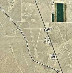
Adamson Landing Field is a closed airport located 1.8 mi south-southeast of Olancha, California.
History
During World War II, the airport was used by the United States Army Air Forces as an auxiliary training airfield for the flying school at Lone Pine Airport, California.
The facility closed sometime after the war. The remains of the runways and ground facilities can be seen in aerial imagery.
See also
References
![]() This article incorporates public domain material from websites or documents of the Air Force Historical Research Agency.
This article incorporates public domain material from websites or documents of the Air Force Historical Research Agency.