Adamsburg, Alabama
| Adamsburg | |
|---|---|
| Unincorporated community | |
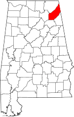
 Adamsburg Location within Alabama | |
| Coordinates: 34°23′56″N 085°40′20″W / 34.39889°N 85.67222°WCoordinates: 34°23′56″N 085°40′20″W / 34.39889°N 85.67222°W [1] | |
| Country | United States |
| State | Alabama |
| County | DeKalb |
| Elevation[1] | 1,467 ft (447 m) |
| Time zone | Central (CST) (UTC-6) |
| • Summer (DST) | CDT (UTC-5) |
| ZIP code | 35967 |
| Area code(s) | 256 |
| GNIS ID[1] | 150061 |
Adamsburg is an unincorporated community located on Lookout Mountain in eastern DeKalb County, Alabama, United States.[1] It is located southeast of the county seat of Fort Payne, and just west of Little River Canyon.
History
Adamsburg was named for Simon Russell Canfield Adams, a minister from Fort Payne who donated land for a school in the community. A post office was established in Adamsburg in 1902, but it has since closed.[2]
Geography
Adamsburg is located at 34°23′56″N 085°40′20″W / 34.39889°N 85.67222°W. Its average elevation is 1,467 feet (447 m) above sea level.[1]
References
- ↑ 1.0 1.1 1.2 1.3 1.4 "Feature Detail Report for: Adamsburg (DeKalb County, Alabama)". Geographic Names Information System. United States Geological Survey. Retrieved January 8, 2013.
- ↑ Foscue, Virginia. Place Names in Alabama. University: U of Alabama P, 1989.
| |||||||||||||||||||||||||||||