Adams Township, Seneca County, Ohio
| Adams Township, Seneca County, Ohio | |
|---|---|
| Township | |
|
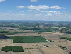
Countryside in southeastern Adams Township | |
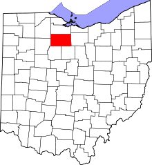
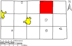 Location of Adams Township in Seneca County | |
| Coordinates: 41°12′25″N 83°1′5″W / 41.20694°N 83.01806°WCoordinates: 41°12′25″N 83°1′5″W / 41.20694°N 83.01806°W | |
| Country | United States |
| State | Ohio |
| County | Seneca |
| Area | |
| • Total | 36.2 sq mi (93.7 km2) |
| • Land | 36.0 sq mi (93.2 km2) |
| • Water | 0.2 sq mi (0.5 km2) |
| Elevation[1] | 794 ft (242 m) |
| Population (2000) | |
| • Total | 1,337 |
| • Density | 37.1/sq mi (14.3/km2) |
| Time zone | Eastern (EST) (UTC-5) |
| • Summer (DST) | EDT (UTC-4) |
| FIPS code | 39-00324[2] |
| GNIS feature ID | 1086940[1] |
Adams Township is one of the fifteen townships of Seneca County, Ohio, United States. The 2000 census found 1,337 people in the township.[3]
Geography
Located in the northeastern part of the county, it borders the following townships:
- Green Creek Township, Sandusky County - north
- York Township, Sandusky County - northeast corner
- Thompson Township - east
- Reed Township - southeast corner
- Scipio Township - south
- Clinton Township - southwest corner
- Pleasant Township - west
- Ballville Township, Sandusky County - northwest corner
Part of the village of Green Springs is located in northern Adams Township.
Name and history
Adams Township was organized in 1826.[4] It was named for John Quincy Adams, sixth President of the United States.[5]
It is one of ten Adams Townships statewide.[6]
Government
The township is governed by a three-member board of trustees, who are elected in November of odd-numbered years to a four-year term beginning on the following January 1. Two are elected in the year after the presidential election and one is elected in the year before it. There is also an elected township fiscal officer,[7] who serves a four-year term beginning on April 1 of the year after the election, which is held in November of the year before the presidential election. Vacancies in the fiscal officership or on the board of trustees are filled by the remaining trustees.
References
- ↑ 1.0 1.1 "US Board on Geographic Names". United States Geological Survey. 2007-10-25. Retrieved 2008-01-31.
- ↑ "American FactFinder". United States Census Bureau. Retrieved 2008-01-31.
- ↑ Seneca County, Ohio — Population by Places Estimates Ohio State University, 2007. Accessed 15 May 2007.
- ↑ Butterfield, Consul Willshire (1848). History of Seneca County: Containing a Detailed Narrative of the Principal Events that Have Occurred Since Its First Settlement Down to the Present Time. D. Campbell. p. 155.
- ↑ Kilbourn, John (1833). "The Ohio Gazetteer, Or a Topographical Dictionary". Scott and Wright. p. 68. Retrieved 12 December 2013.
- ↑ "Detailed map of Ohio" (PDF). United States Census Bureau. 2000. Archived (PDF) from the original on 16 March 2007. Retrieved 2007-02-16.
- ↑ §503.24, §505.01, and §507.01 of the Ohio Revised Code. Accessed 4/30/2009.
External links
| |||||||||||||||||||||||||||||||||