Acidava
 | |
 Location within Romania | |
| Alternative name(s) | Acidaua |
| Attested by | Tabula Peutingeriana |
| Location | |
| Coordinates | 44°22′31″N 24°16′39″E / 44.375411°N 24.277634°ECoordinates: 44°22′31″N 24°16′39″E / 44.375411°N 24.277634°E |
| Altitude | 127 m |
| Town | Enoșești |
| County | Olt County |
| Country |
|
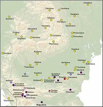
Acidava (Acidaua) was a Dacian and later Roman fortress on the Olt river near the lower Danube.[1] The settlements remains are located in today's Enoşeşti, Olt County, Romania.
After the Roman conquest of Dacia by Roman Emperor Trajan, Acidava became a civilian and military center, with castra being built in the area. Acidava was part of the Limes Alutanus, a line of fortifications built under emperor Hadrian running north-south along the Alutus - the Olt river.[2] The function of the limes was to monitor the Roxolani to the east and deter any possible attacks.[3]
Acidava is depicted in the Tabula Peutingeriana between Romula and Rusidava.[4] The same document depicts a second Acidava, between Cedoniae and Apula, but some authors believe it is actually a copy error[5] and the correct name is Sacidava, another Dacian town.
See also
Notes
References
- Grumeza, Ion (2009). Dacia: Land of Transylvania, Cornerstone of Ancient Eastern Europe. Hamilton Books. ISBN 0-7618-4465-1.
The shores of the Danube were well monitored from the Dacian fortresses Acidava, Buricodava, Dausadava (the shrine of the wolves), Diacum, Drobeta (Turnu Severin), Nentivava (Oltenita), Suvidava (Corabia), Tsirista, Tierna/Dierna (Orsova) and what is today Zimnicea. Downstream were also other fortresses: Axiopolis (Cernadova), Barbosi, Buteridava, Capidava(Topalu), Carsium(Harsova), Durostorum(Silistra), Sacidava/Sagadava (Dunareni) along with still others...
- Blejan, Adrian (1998). Dacia Felix - Istoria Daciei Romane (PDF) (in Romanian). Retrieved 2010-12-08.
- Vinereanu, Mihai (2002). Originea geto-dacă a limbii române (in Romanian). Chisinau: Pontos.
- Olteanu, Sorin. "Linguae Thraco-Daco-Moesorum - Toponyms Section". Linguae Thraco-Daco-Moesorum (in Romanian). Retrieved 8 December 2010.
External links
| Wikimedia Commons has media related to Dacia and Dacians. |
- Archaeological sites around Enoşeşti on the Mapserver for Romanian National Cultural Heritage
- Many items recovered from Acidava are available at the Olt County Museum, Romania
- Acidava in the Princeton Encyclopedia of Classical Sites
- Acidava in the Dictionary of Greek and Roman Geography (1854)
- Sorin Olteanu's Project: Linguae Thraco-Daco-Moesorum - Toponyms Section
- A street in Bucharest, having the ancient city name: Strada Acidava