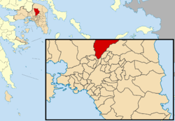
Acharnes
| Acharnes Αχαρνές | |
|---|---|
 | |
 Acharnes | |
|
Location within the region  | |
| Coordinates: 38°5′N 23°44′E / 38.083°N 23.733°ECoordinates: 38°5′N 23°44′E / 38.083°N 23.733°E | |
| Country | Greece |
| Administrative region | Attica |
| Regional unit | East Attica |
| Government | |
| • Mayor | Sotiris Douros (Ind.) |
| Area | |
| • Municipality | 149.0 km2 (57.5 sq mi) |
| • Municipal unit | 146.4 km2 (56.5 sq mi) |
| Elevation | 186 m (610 ft) |
| Population (2011)[1] | |
| • Municipality | 106,943 |
| • Municipality density | 720/km2 (1,900/sq mi) |
| • Municipal unit | 100,743 |
| • Municipal unit density | 690/km2 (1,800/sq mi) |
| Time zone | EET (UTC+2) |
| • Summer (DST) | EEST (UTC+3) |
| Postal code | 136 xx |
| Area code(s) | 210 |
| Vehicle registration | Z |
| Website | www.acharnes.gr |
Acharnes (Greek: Αχαρνές, before 1915: Μενίδι Menidi[2]) is a suburban town in Attica, Greece. With 106,943 inhabitants (2011 census), it is the most populous municipality in East Attica. It is part of the Athens metropolitan area.
Geography
The northern part of the municipality is covered by the forested Parnitha mountains. The southern part is in the plain of Athens, and is densely populated. The built-up area of Acharnes, in this southern part of the municipality, is continuous with that of the adjacent suburbs to the west, east and south. The centre of Acharnes is 11 kilometres (7 miles) due north of Athens city centre. The two other settlements in the municipality, Thrakomakedones and Varympompi, are situated further north, in the foothills of Parnitha.
Acharnes is crossed by several important roads and railways, including Motorway 6, the Piraeus–Platy railway and the Athens Airport–Kiato railway. The Acharnes Railway Center is the main railway junction of Attica.
Acharnes is home to the Folk Art Museum of Acharnes.
History
Acharnes was named after the deme Acharnae (Ancient Greek: Ἁχαρναί), a subdivision of Attica in classical antiquity. The Athenian playwright Aristophanes characterised the inhabitants of Acharnae as peasants in his play The Acharnians. Acharnes suffered significant damage from the 1999 Athens earthquake, being very close to the epicenter.
Municipality
The municipality Acharnes was formed at the 2011 local government reform by the merger of the following 2 former municipalities, that became municipal units:[3]
- Acharnes
- Thrakomakedones
Historical population
| Year | Municipal unit | Municipality |
|---|---|---|
| 1981 | 41,068 | - |
| 1991 | 61,352 | - |
| 2001 | 75,341 | - |
| 2011 | 100,743 | 106,943 |
Sporting teams
- Acharnaikos F.C. - fourth division
See also
- List of municipalities of Attica
References
- ↑ "Detailed census results 2011" (in Greek).
- ↑ Name changes of settlements in Greece
- ↑ Kallikratis law Greece Ministry of Interior (Greek)
 |
Fyli | Avlonas | Malakasa, Afidnes |  |
| Ano Liosia | |
Agios Stefanos, Kryoneri | ||
| ||||
| | ||||
| Zefyri, Kamatero | Nea Filadelfeia, Metamorfosi | Nea Erythraia, Kifisia |
| ||||||||||||||||||||||||||||||||||||||||||||||
| ||||||
