Abra (province)
| Abra | |||
|---|---|---|---|
| Province | |||
| |||
 Location in the Philippines | |||
| Coordinates: 17°35′N 120°45′E / 17.583°N 120.750°ECoordinates: 17°35′N 120°45′E / 17.583°N 120.750°E | |||
| Country | Philippines | ||
| Region | Cordillera Administrative Region (CAR) | ||
| Founded | March 10, 1917 | ||
| Capital | Bangued | ||
| Government | |||
| • Type | Province of the Philippines | ||
| • Governor | Eustaquio Bersamin (LP) | ||
| • Vice Governor | Chari Bersamin (LP) | ||
| Area[1] | |||
| • Total | 4,165.25 km2 (1,608.21 sq mi) | ||
| Area rank | 31st out of 81 | ||
| Population (2010)[2] | |||
| • Total | 234,733 | ||
| • Rank | 68th out of 81 | ||
| • Density | 56/km2 (150/sq mi) | ||
| • Density rank | 80th out of 81 | ||
| Divisions | |||
| • Independent cities | 0 | ||
| • Component cities | 0 | ||
| • Municipalities | 27 | ||
| • Barangays | 303 | ||
| • Districts | Lone District of Abra | ||
| Time zone | PHT (UTC+8) | ||
| ZIP code | 2800 to 2826 | ||
| Dialing code | 74 | ||
| ISO 3166 code | PH-ABR | ||
| Spoken languages | Ilocano, Tinguian, Isneg, Tagalog, English | ||
| Website |
www | ||


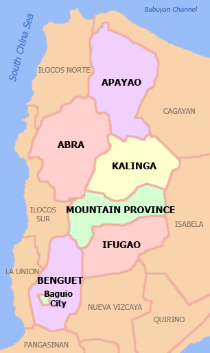
Abra is a landlocked province of the Philippines in the Cordillera Administrative Region in Luzon. Its capital is Bangued, is bordered by Ilocos Norte and Apayao on the north, Ilocos Sur and Mountain Province on the south, Ilocos Norte and Ilocos Sur on the west, and Kalinga and Apayao on the east.
History
The first inhabitants of Abra were the ancestors of the Bontocs and the Ifugaos. These inhabitants eventually left to settle in the old Mountain Province. Other early inhabitants were the Tingguians, or Itnegs, as they are also known. In 1598, a Spanish garrison was established in Bangued to protect Christian Ilocanos from Tingguian raids. Originally the area was called El Abra de Vigan ("The Opening of Vigan"). During the British Occupation of the Philippines, Gabriela Silang and her army fled to Abra from Ilocos and continued the revolt begun by her slain husband, Diego Silang. She was captured and hanged by the Spanish in 1763.
In 1818, the Ilocos region, including Abra, was divided into Ilocos Norte and Ilocos Sur. In 1846, Abra was created[3] as a political-military province with Lepanto as a sub-province. It remained so until the arrival of the Americans in 1899.
In 1908 the Philippine Commission once again in annexed Abra to Ilocos Sur in an attempt to resolve Abra's financial difficulties. On March 9, 1917, the Philippine Assembly re-established Abra as a province.
In 1942, the Japanese forces occupied the Philippines and entered Abra.
Abra was liberated by the Philippine Commonwealth forces and local Cordilleran guerrillas during the Battle of Abra in 1945, at the end of the Second World War.
The revolutionary Marxist priest, Conrado Balweg, who fought for the rights of the Cordillera tribes, began his crusade in Abra. After successfully negotiating a peace accord with Balweg's group in 1987, the Philippine government created the Cordillera Administrative Region, which includes Abra.
Geography
Physical
Abra is hemmed in by the towering mountain ranges of the Ilocos in the west and the Cordillera Central in the east. The Abra River runs from the south in Benguet to the west and central areas, bisecting the whole Abra Valley. It is joined by the Tineg River originating from the eastern uplands at a point near the municipality of Dolores.
Administrative

Abra is subdivided into 27 municipalities, all of which belong to a lone legislative district.[4]
Table Legend:
† Provincial capital
| Municipality | Land area (km2)[4] | Population (2010)[5] | Pop. density (per km2) | No. of barangays | ZIP code | Income class[4] | Location |
|---|---|---|---|---|---|---|---|
| |
|||||||
| Bangued † | 105.7 | 43,936 | 415.7 | 31 | 2800 | 1st |  |
| Boliney | 216.92 | 4,063 | 18.7 | 8 | 2815 | 5th |  |
| Bucay | 107.17 | 17,126 | 159.8 | 21 | 2805 | 5th |  |
| Bucloc | 63.77 | 2,176 | 34.1 | 4 | 2817 | 6th |  |
| Daguioman | 114.37 | 1,715 | 15 | 4 | 2816 | 5th |  |
| Danglas | 156.02 | 4,734 | 30.3 | 7 | 2825 | 5th |  |
| Dolores | 47.45 | 11,499 | 242.3 | 15 | 2801 | 5th |  |
| La Paz | 51.41 | 14,882 | 289.5 | 12 | 2826 | 5th |  |
| Lacub | 295.3 | 2,977 | 10.1 | 6 | 2821 | 5th |  |
| Lagangilang | 101.44 | 13,824 | 136.3 | 17 | 2802 | 5th |  |
| Lagayan | 215.97 | 4,477 | 20.7 | 6 | 2824 | 5th |  |
| Langiden | 116.29 | 3,170 | 27.3 | 6 | 2807 | 5th |  |
| Licuan-Baay (Licuan) | 256.42 | 4,864 | 19 | 11 | 2819 | 5th |  |
| Luba | 148.27 | 6,391 | 43.1 | 8 | 2813 | 5th |  |
| Malibcong | 283.17 | 3,807 | 13.4 | 12 | 2820 | 5th |  |
| Manabo | 110.95 | 10,756 | 96.9 | 11 | 2810 | 5th |  |
| Peñarrubia | 38.29 | 6,544 | 170.9 | 9 | 2804 | 6th |  |
| Pidigan | 49.15 | 11,528 | 234.5 | 15 | 2806 | 5th |  |
| Pilar | 66.1 | 9,908 | 149.9 | 19 | 2812 | 5th |  |
| Sallapadan | 128.62 | 5,985 | 46.5 | 9 | 2818 | 5th |  |
| San Isidro | 48.07 | 4,888 | 101.7 | 9 | 2809 | 5th |  |
| San Juan | 64.08 | 10,546 | 164.6 | 19 | 2823 | 5th |  |
| San Quintin | 66.59 | 5,233 | 78.6 | 6 | 2808 | 5th |  |
| Tayum | 61.14 | 13,940 | 228 | 11 | 2803 | 5th |  |
| Tineg | 744.8 | 4,668 | 6.3 | 10 | 2822 | 2nd |  |
| Tubo | 409.87 | 5,719 | 14 | 10 | 2814 | 4th |  |
| Villaviciosa | 102.93 | 5,377 | 52.2 | 8 | 2811 | 5th |  |
| Abra Total | 4,165.25 | 234,733 | 56.4 | 303 | 2800 - 2826 | 3rd[1] | |
*Note: Italicized names are former names.
Barangays
The 27 municipalities of the province comprise a total of 303 barangays, with Poblacion in La Paz as the most populous in 2010, and Pattaoig in San Juan as the least.[5][6]
Demographics
| Population census of Abra | ||
|---|---|---|
| Year | Pop. | ±% p.a. |
| 1990 | 184,743 | — |
| 1995 | 195,964 | +1.11% |
| 2000 | 209,491 | +1.44% |
| 2007 | 230,953 | +1.35% |
| 2010 | 234,733 | +0.59% |
| Source: National Statistics Office[2] | ||
Abra's inhabitants are mostly descendants of Ilocano settlers and members of the Tingguian tribe. As of 2011, the population of the province is 240,141.
The predominant languages are Ilocano[7] and Itneg.[8] Based on the 2000 census survey, the majority of the province population is Ilocano 71.9%. Other ethnic groups living in the province are the Tinguian 18.7%, Ibanag 4.5%, Isneg 3.2% and Tagalog 0.4%.[9]
Economy
As of 1990, there were 743 cottage industries in Abra, of which 208 are registered with the Department of Trade and Industry. 59% are engaged in bamboo and rattan craft making, both leading industries in the area.
In 1992, the natural dye industry, together with loom weaving and embroidery, was revived by former Governor Ma. Zita Claustro-Valera, the first female governor of Abra.
Abra's economy is agriculture-based. Its major crops are rice, corn, and root crops; commercial products include coffee, tobacco, and coconut. Extensive grassland and pasture areas are used for livestock production.[10][11][12][13]
References
- ↑ 1.0 1.1 "List of Provinces". PSGC Interactive. Makati City, Philippines: National Statistical Coordination Board. Retrieved 30 December 2013.
- ↑ 2.0 2.1 "Population and Annual Growth Rates for The Philippines and Its Regions, Provinces, and Highly Urbanized Cities" (PDF). 2010 Census and Housing Population. National Statistics Office. Retrieved 30 December 2013.
- ↑ Fernández, Leandro Heriberto. A Brief History of the Philippines. Ginn. p. 195.
- ↑ 4.0 4.1 4.2 "Province: ABRA". PSGC Interactive. Makati City, Philippines: National Statistical Coordination Board. Retrieved 30 December 2013.
- ↑ 5.0 5.1 "2010 Census of Population and Housing: Population Counts - Cordillera Administrative Region" (PDF). National Statistics Office (Philippines), April 4, 2012. Retrieved 16 November 2014.
- ↑ "Province: Abra". Philippine Statistics Authority - National Statistical Coordination Board. Retrieved 30 December 2014.
- ↑ Dalby, Andrew (2004-02-18). Dictionary of Languages: The Definitive Reference to More Than 400 Languages. Columbia University Press. p. 264. ISBN 978-0-231-11569-8.
- ↑ Tryon, Darrell T. (1994). Comparative Austronesian Dictionary: An Introduction to Austronesian Studies. Ratzlow-Druck. p. 171. ISBN 3-11-012729-6.
- ↑ http://www.census.gov.ph/data/pressrelease/2002/pr0234tx.html
- ↑ http://www.congress.gov.ph/bis/hist_show.php?save=0&journal=&switch=0&bill_no=HB04708&congress=14
- ↑ http://www.congress.gov.ph/bis/hist_show.php?save=0&journal=&switch=0&bill_no=HB04710&congress=14
- ↑ http://www.congress.gov.ph/bis/hist_show.php?save=0&journal=&switch=0&bill_no=HB04711&congress=14
- ↑ http://www.congress.gov.ph/bis/hist_show.php?save=0&journal=&switch=0&bill_no=HB05366&congress=14
External links
| Wikimedia Commons has media related to Abra (province). |
- The Website of the Province of Abra
- Philippine Standard Geographic Code
- Philippine Census Information
- Featuring Tingguian Cultures, Traditions and Beliefs
- History articles and links on Bucay and Abra
- WOW Philippines - Abra
 |
Ilocos Norte | Apayao | | |
| Ilocos Sur | |
Kalinga | ||
| ||||
| | ||||
| Ilocos Sur | Mountain Province |
| ||||||||||||||
| ||||||||||||||||||||||||||||||||||


| |||||||||||||||||||||||||||||||||||||||||||||