Abovyan
- For the village in Ararat Province, see Abovyan, Ararat.
Coordinates: 40°16′26″N 44°37′32″E / 40.27389°N 44.62556°E
| Abovyan Աբովյան | |
|---|---|
|
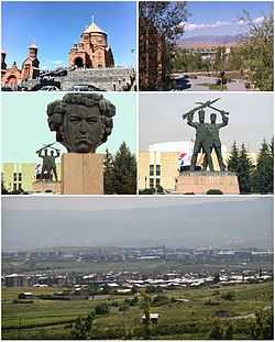
From top left: Surp Hovhannes Church • Abovyan landscape Statue of Khachatur Abovian • Russian-Armenian brotherhood memorial at the town hall Panoramic view of Abovyan | |
 Abovyan Աբովյան | |
| Coordinates: 40°16′26″N 44°37′32″E / 40.27389°N 44.62556°E | |
| Country |
|
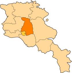
| Marz (province) | Kotayk |
| Founded | 1963 |
| Government | |
| • Mayor | Karapet Guloyan |
| Area | |
| • Total | 11 km2 (4 sq mi) |
| Elevation | 1,450 m (4,760 ft) |
| Population (2009) | |
| • Total | 46,000 |
| • Density | 4,200/km2 (11,000/sq mi) |
| Time zone | UTC (UTC+4) |
| Area code(s) | (+374)222 |
| Website | Abovyan portal |
| Sources: Population [1] | |
Abovyan or Abovian (Armenian: Աբովյան) is a town in the Kotayk Province of Armenia. It is located 16 kilometres (10 miles) northeast of Yerevan and 32 kilometres (20 miles) southeast of the province centre Hrazdan. In 2009, the estimated population of the town was 46,000, down from 59,000 at the 1989 census. Abovyan covers an area of 11 square kilometres (4.2 square miles).
With a motorway and railway running through the city connecting Yerevan with the areas of the northeast, Abovyan is considered a satellite city of the Armenian capital. Therefore, Abovyan is generally known as the "northern gate of Yerevan".
History
During his researches in 1960, historian Mesrop Smbatiants found king Argishti I's Urartian cuneiform which narrates about the conquest of Darani (the pre-Urartian name of modern-day Abovyan area) of Ulusan country. Excavations and found materials proved that the area was inhabited since the end of the 4th century BC. During the excavations, the remains of a fortress, a cemetery and old shelters were also found with several objects and remnants of three stages of the Bronze Age.[2]
During the ancient Kingdom of Armenia, the western area of modern-day Abovyan was part of the Kotayk canton of Ayrarat province while the eastern area was part of Mazaz canton of the same province.
Between the 5th and 7th centuries AD, the region became under the administration of the Armenian noble dynasty of Amatuni.
In the Middle Ages, the area was known as Elar. According to the Armenian historian Stepanos Orbelian of the 13th century, Elar was awarded to Liparit Orbelian of the Orbelian Dynasty by prince Atabek Ivane.
Under the Persian rule, Elar was part of the Erivan Khanate. After the Russian conquest of Armenia in 1828, Elar became part of the Armenian Oblast and subsequently of the Erivan Governorate which was formed in 1849-1850.
Until 1961, the small village of Elar (part of modern-day Abovyan) was the largest settlement of the area, when it was renamed Abovyan in the honour of the Armenian writer Khachatur Abovian. Two years later in 1963, the town was founded on the same area by the decision of the Soviet government.
The modern city of Abovyan was built in 1962-1963 on a plateau located between Hrazdan and Azat rivers. The city has rapidly developed as an industrial centre for the entire Armenian SSR.
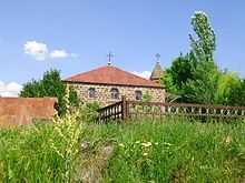
The Surp Stepanos medieval church (renovated in 1851) stands on a nearby hill in Elar district.
More than 90% of the population is ethnic Armenian, mainly diasporan Armenians relocated from Syria, Iran and Lebanon during the 1960s. Minor communities of Kurds, Yazidis, Russians and Assyrians are also found in Abovyan.[3]
Geography and Climate
Abovyan is built on Kotayk plateau between the rivers of Hrazdan, Azat and Getar at a height of 1450 meters above sea level. It is surrounded with Geghama mountain range and mount Hatis from the northwest, Gutanasar mountains from the north, Hrazdan gorge from the west and the heights of Nork from the south. The climate is continental and dry with relatively hot summers and cold winters.
| Climate data for Abovyan | |||||||||||||
|---|---|---|---|---|---|---|---|---|---|---|---|---|---|
| Month | Jan | Feb | Mar | Apr | May | Jun | Jul | Aug | Sep | Oct | Nov | Dec | Year |
| Average high °F (°C) | 33.1 (0.6) |
35.6 (2) |
45.7 (7.6) |
57.7 (14.3) |
67.1 (19.5) |
75.2 (24) |
82.2 (27.9) |
81.7 (27.6) |
75.0 (23.9) |
63.3 (17.4) |
49.6 (9.8) |
37.8 (3.2) |
58.67 (14.82) |
| Average low °F (°C) | 16.7 (−8.5) |
18.9 (−7.3) |
27.3 (−2.6) |
36.5 (2.5) |
44.2 (6.8) |
50.5 (10.3) |
56.7 (13.7) |
56.5 (13.6) |
48.2 (9) |
39.6 (4.2) |
30.9 (−0.6) |
22.5 (−5.3) |
37.38 (2.98) |
| Average precipitation inches (mm) | 0.71 (18) |
0.87 (22.1) |
1.18 (30) |
1.81 (46) |
2.80 (71.1) |
2.09 (53.1) |
1.22 (31) |
0.98 (24.9) |
0.87 (22.1) |
1.34 (34) |
1.02 (25.9) |
0.71 (18) |
15.6 (396.2) |
There is a small lake in the city called "Akna".
Arzni town-resort is located only 6 kilometres (4 miles) west of Abovyan.
Economy
Abovyan is a quite industrialized city. It has many large enterprises among which are the factories of concrete construction, stone processing and chemical productions. The town is home to one of the leading beer producers in the Armenian market, Kotayk Brewery, owned by Gagik Tsarukyan's Multi Group Holding. The factory produces a variety of lager beer under the brands Kotayk, Erebuni and Abovyan's Tshani.[4] Several companies in Abovyan export the entire volume of their industrial output.
Sports, education and religion
.jpg)
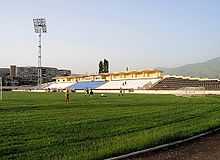
- FC Kotayk of Abovyan founded in 1955, is one of the oldest football clubs in Armenia. Like many other football teams in the country, FC Kotayk was forced to default from the Armenian football league and consequently from professional football since 2005, due to financial crisis. The short-lived King Delux F.C. of Abovyan played a single season in the Armenian First League of 2012-13. The town is home to the Abovyan City Stadium with a capacity of 3,946 seats. There is a sport school in the town operated by the municipality.
- Abovyan has 10 public education schools, 9 kindergartens and 2 state intermediate colleges. It is also home to the Abovyan University named after Levon Orbeli. The city hosts 2 significant institutions of science in Amrneia: The Republican Hospital of tuberculosis and the Institute of Biological Microbes of the Armenian National Academy of Sciences. Many cultural centres operate in the city, such as the cultural palace of Abovyan, the community creative centre for children and teenagers, the musical school, the art school, the public library and the museum of Abovyan.
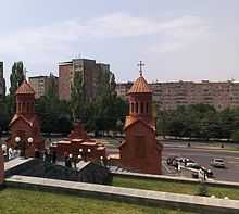
- The church of Surp Stepanos opened in 1851, located in the southern Elar neighbourhood of modern-day Abovyan. The church was closed during the Soviet years. It remained closed until 2010 when it was entirely renovated. In 28 November of the same year, the church of Surp Stepanos was reopened for the public. The other church in the town is the Surp Hovhannes church opened in 2013 by the efforts of the Armenian businessman Gagik Tsarukyan. The architect of the church is Artak Ghulyan.
International relations
Twin towns – Sister cities
Abovyan is twinned with:

 Villeurbanne, Rhône-Alpes, France (since 1990)
References
- ↑ Armstats:Population Archived 11 January 2011 at WebCite
- ↑ Union of Communities of Armenia:Abovyan (Kotayk) Archived 24 January 2011 at WebCite
- ↑ Abovyan city:Kurdish Community of Abovyan city Archived 24 January 2011 at WebCite
- ↑ Kotayk Brewery:History Archived 24 January 2011 at WebCite
- Abovyan at GEOnet Names Server
- Report of the results of the 2001 Armenian Census, National Statistical Service of the Republic of Armenia
External links
![]() Media related to Abovyan at Wikimedia Commons
Media related to Abovyan at Wikimedia Commons