Ablain-Saint-Nazaire
| Ablain-Saint-Nazaire | ||
|---|---|---|
|
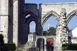
Ruins of the church destroyed during World War I | ||
| ||
 Ablain-Saint-Nazaire | ||
|
Location within Nord-Pas-de-Calais region  Ablain-Saint-Nazaire | ||
| Coordinates: 50°23′34″N 2°42′48″E / 50.3928°N 2.7133°ECoordinates: 50°23′34″N 2°42′48″E / 50.3928°N 2.7133°E | ||
| Country | France | |
| Region | Nord-Pas-de-Calais | |
| Department | Pas-de-Calais | |
| Arrondissement | Arras | |
| Canton | Vimy | |
| Intercommunality | Lens-Liévin | |
| Government | ||
| • Mayor (2008–2014) | Dominique Robillart | |
| Area1 | 9.85 km2 (3.80 sq mi) | |
| Population (2009)2 | 1,828 | |
| • Density | 190/km2 (480/sq mi) | |
| INSEE/Postal code | 62001 / 62153 | |
| Elevation |
77–188 m (253–617 ft) (avg. 95 m or 312 ft) | |
|
1 French Land Register data, which excludes lakes, ponds, glaciers > 1 km² (0.386 sq mi or 247 acres) and river estuaries. 2 Population without double counting: residents of multiple communes (e.g., students and military personnel) only counted once. | ||
Ablain-Saint-Nazaire is a commune in the Pas-de-Calais department in northern France.
Geography
A farming village located 8 miles (12 km) north of Arras, on the D57 road. It was rebuilt after being destroyed during World War I. The Saint-Nazaire stream, which passes through the commune, is a small tributary of the river Deûle.
Population
| Historical population | ||
|---|---|---|
| Year | Pop. | ±% |
| 1962 | 1,295 | — |
| 1968 | 1,293 | −0.2% |
| 1975 | 1,388 | +7.3% |
| 1982 | 1,482 | +6.8% |
| 1990 | 1,715 | +15.7% |
| 1999 | 1,843 | +7.5% |
| 2005 | 1,890 | +2.6% |
| 2009 | 1,828 | −3.3% |
History
At the start of World War I, the Battle of Lorette lasted for 12 months, from October 1914 to October 1915, resulting in high casualties on both sides: 100,000 killed and as many wounded. A French national cemetery was built on 13 hectares nearby and comprises 20,000 graves, laid out irrespective of rank or military training. General Barbot has a private soldier buried next to him, on his right. In eight ossuaries, around the base of the lantern tower, are the remains of 22,970 unidentified soldiers. A portion of the cemetery has been reserved for Muslim soldiers.
Sights
- The church of St. Pierre, dating from the twentieth century.
- The ruins of the fifteenth century church, destroyed in World War I.
- The war museum.
See also
References
External links
| Wikimedia Commons has media related to Ablain-Saint-Nazaire. |
- The Communauté d'Agglomération of Lens-Liévin (French)
- Official website of Ablain-Saint-Nazaire (French)
- Ablain-Saint-Nazaire on the Quid website (French)

