Abetone
| Abetone | ||
|---|---|---|
| Comune | ||
| Comune dell'Abetone | ||
|
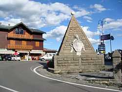
Monument in Abetone | ||
| ||
 Abetone Location of Abetone in Italy | ||
| Coordinates: 44°9′46″N 10°39′55″E / 44.16278°N 10.66528°ECoordinates: 44°9′46″N 10°39′55″E / 44.16278°N 10.66528°E | ||
| Country | Italy | |
| Region | Tuscany | |
| Province | Pistoia (PT) | |
| Frazioni | Cecchetto, Fontana Vaccaia, Le Regine, Faidello, Val di Luce | |
| Government | ||
| • Mayor | Giampiero Danti | |
| Area | ||
| • Total | 31.2 km2 (12.0 sq mi) | |
| Elevation | 1,388 m (4,554 ft) | |
| Population (December 2004) | ||
| • Total | 699 | |
| • Density | 22/km2 (58/sq mi) | |
| Demonym | Abetonesi | |
| Time zone | CET (UTC+1) | |
| • Summer (DST) | CEST (UTC+2) | |
| Postal code | 51021 | |
| Dialing code | 0573 | |
| Website | Official website | |

Abetone is a comune (municipality) in the Province of Pistoia in the Italian region Tuscany, located about 80 kilometres (50 mi) northwest of Florence and about 49 kilometres (30 mi) northwest of Pistoia. As of 31 December 2004, it had a population of 699 and an area of 31.2 square kilometres (12.0 sq mi).[1]
Abetone borders the following municipalities: Bagni di Lucca, Coreglia Antelminelli, Cutigliano, Fiumalbo.
History
Abetone (in Italian: "large fir") was created as a custom post on the main road from the Grand Duchy of Tuscany and the Duchy of Modena, built from 1732. The name derives from that of a large tree cut down to allow the construction proceed.
Starting from the early 20th century it became a renowned skiing resort. Zeno Colò, one of the greatest Italian skiers, was born here in 1920.
Points of interest
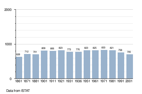
Demographic evolution
References
External links
| Wikimedia Commons has media related to Abetone. |
- (Italian)Official website
- (Italian)Abetone Tourist Web Portal