Aberdeen, California
| Aberdeen | |
|---|---|
| Unincorporated community | |
 Aberdeen Location in California | |
| Coordinates: 36°58′41″N 118°15′12″W / 36.97806°N 118.25333°WCoordinates: 36°58′41″N 118°15′12″W / 36.97806°N 118.25333°W | |
| Country | United States |
| State | California |
| County | Inyo County |
| Elevation[1] | 3,914 ft (1,193 m) |
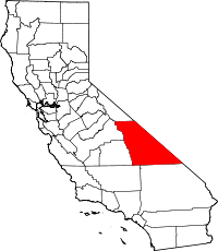
Aberdeen (formerly, Aberdeen Station and Tibbets) is an unincorporated community in Inyo County, California.[1] It is located 12.5 miles (20 km) north-northwest of Independence,[2] at an elevation of 3914 feet (1193 m).[1]
History
Aberdeen was named after Aberdeen, Scotland.[3] Aberdeen was originally located east-northeast of its present site at 36°59′30″N 118°12′40″W / 36.99167°N 118.21111°W on the Southern Pacific Railroad.[2] The Tibbotts post office opened in 1895, moved and changed its name to Aberdeen in 1896, closed in 1898, reopened in 1921 and closed for good in 1934.[2] The name Tibbets commemorates a local ranching family.[2]
References
- ↑ 1.0 1.1 1.2 U.S. Geological Survey Geographic Names Information System: Aberdeen, California
- ↑ 2.0 2.1 2.2 2.3 Durham, David L. (1998). California's Geographic Names: A Gazetteer of Historic and Modern Names of the State. Clovis, Calif.: Word Dancer Press. p. 1143. ISBN 1-884995-14-4.
- ↑ Nancy Capace; Somerset Publishers, Incorporated (1 June 1999). Encyclopedia of California. North American Book Dist LLC. p. 237. ISBN 978-0-403-09318-2.
