Abbottabad District
| Abbottabad District | |
|---|---|
| District | |
.svg.png) Khyber Pakhtunkhwa's location in the Pakistan | |
| Country | Pakistan |
| Province | Khyber Pakhtunkhwa |
| Headquarters | Abbottabad |
| Area | |
| • Total | 1,969 km2 (760 sq mi) |
| Population (2014) | |
| • Total | 1,182,000 |
| • Density | 600/km2 (1,600/sq mi) |
| Time zone | PST (UTC+5) |
| Number of Union Councils | 51 |
| Number of Tehsils | 2 |
| Website | http://www.abbottabad.gov.pk |
Abbottabad (Urdu: ضلع ایبٹ آباد) also spelled Abbotabad is a district in the Khyber Pakhtunkhwa province of Pakistan. The district covers an area of 1,969 km2 with the city of Abbottabad being the principal town.[1] Neighbouring districts are Mansehra to the north, Muzaffarabad to the east, Haripur to the west, and Rawalpindi to the south.[2]
History

Origin of name
The district is named after Major James Abbott, the first deputy commissioner of Hazara (1849–1853).[2]
Hazara
During British rule Abbottabad became the capital of Hazara division, which was named after and contained the Hazara valley, a small valley in the outermost Himalayas, between the Indus in the west and Kashmir in the east.[3]
The current Abbottabad District was originally a tehsil of Hazara, the Imperial Gazetteer of India described it as follows:
| “ | Tahsīl of Hazāra District, North-West Frontier Province, lying between 33°49' and 34° 22' N. and 72°55' and 73° 31' E., with an area of 715 square miles (1,850 km2). It is bounded on the east by the Jhelum, which divides it from Pūnch and the Punjab District of Rawalpindi; and it comprises part of the mountain valleys drained by the Dor and Harroh rivers, together with the hill country eastward. The hill-sides to the north and north-east are covered with timber forest. The population in 1901 was 194,632, compared with 175,735 in 1891. It contains the towns of ABBOTTABAD (population, 7,764), the tahsil and District headquarters, and NAWASHAHR (4,114); and 359 villages. The land revenue and cesses amounted in 1903-4 to Rs. 97,000.[4] | ” |
As Hazara District covered a large area, the provincial government decided for administrative purposes to divide Hazara into Abbottabad, Mansehra, Kohistan, Haripur and Batagram districts. In 1981 Hazara was divided and Abbottabad was formed as a district with two tehsils. In 1981 the total area of District Abbottabad was 3,665 square miles (9,490 km2) with a population of 977,212. Tehsil Abbottabad (a sub division of the district) – had an area of 1,802-square-mile (4,670 km2) and a population of 667,328 including 51% of Circle Bakote that also include Union Council Birote, The highly populated area of circle Bakote. In 1990 the total population of the district was 1,425,032 including Circle Bakote 43%.
Earthquake of 2005
In October 2005, the district was hit by an earthquake, nine Union Councils were badly hit, these were Dalola, Boi, Balakot, Pattan Kalan, Nambal, Berote, Kukmong, Palak and Beerangali located across the two rivers Jehlum and Kunhar.[5]
Demography
Chhachi, Gujarii, Hindko, Majhi, Pahari, Pashto and Potohari, some of which are considered dialects of Punjabi and Urdu, are the predominant languages of the district.
According to the 1998 census of Pakistan the population of the district was 880,666.[6] According to an estimate this had risen to 1.05 million in 2008.[7] according to the old Hazara gazetteers the main tribes here are the Dhunds, Tanolis, Awans, Jadoons, Kashmiris, Shilmani, Sarrara (a section of the Dhund-Abbasi), Karlals, Qureshi, Mughals, Gujjars, Syed and Satti.[8]
Famous peaks
Miranjani (3,313m) and Mukeshpuri are the highest peaks in this district.
Parks and protected areas
Under the Khyber Pakhtunkhwa Wildlife (Protection, Preservation, Conservation and Management) Act of 1975, two areas have been designated with the district: Ayubia National Park and Qalanderabad game reserve.[9] Both areas cover only 6% of the landed area of the district.[9]
Ayubia National Park
Established in 1984, this park covers an area of over 3,312 ha.[9]
Qalanderabad game reserve
Established in 1980 with an area of 8,940ha.[9]
Minerals
Some of the minerals mined within the district are barite, dolomite, granite, gypsum, limestone, magnesite, marble, phosphate, red ochre and red oxide.
Subdivisions
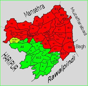
Abbottabad district is divided into two tehsils, Abbottabad and Havelian as well as one urban administration area – Nawanshehr. There are fifty-one Union Councils in the district, 35 in Abbottabad tehsil and 16 in Havelian. These are:
Abbottabad Tehsil
|
|
|
- kangher pain
Havelian Tehsil
|
|
Government and politics
Election 2008
With the announcement by the Election commission of Pakistan that elections would be held on 8 January 2008[10] more than a dozen candidates filed their nomination papers in Abbottabad.[11]
Political campaigns
Abbottabad was the centre of the Sooba Hazara movement that started after national assembly passed 18th amendment to change the name of province from North West Frontier Province (NWFP) to Khyber Pakhtunkhwa. The former governor of the province has been vocal in this opposition to the new name[12]
Provincial assembly
The district is represented in the provincial assembly by five elected MPAs:[13]
National assembly
The district is represented in the National Assembly by two elected MNAs who represent the following constituencies:[14]
Education
Abbottabad hosts a large number of public and private schools and colleges, including Abbottabad Public School, Ayub Medical College, Army Burn Hall College, Frontier Medical College, Peshawar university of Engineering and Technology (Abbottabad campus) and Pakistan International Public School and College. The city also hosts the first private medical college for women in Pakistan, Women Medical College, established in 1999. Its literacy rate is higher than national average.
See also
External links
| Wikimedia Commons has media related to Category:Abbottabad district. |
References
- ↑ Geography of District Abbottabad
- ↑ 2.0 2.1 IUCN Pakistan (2004). Abbottabad – State of the environment and Development. IUCN Pakistan and Khyber Pukhtoonkhwa: Karachi, p. 2.
- ↑ Hazara – Nordisk familjebok
- ↑ Imperial Gazetteer of India, v. 5, p. 1
- ↑ [EARTHQUAKE RECONSTRUCTION AND REHABILITATION AUTHORITY – ERRA]
- ↑ "Abbottabad District at a Glance". Islamabad: Population Census Organization. Retrieved 3 March 2012.
- ↑ District Profile: Northern Khyber Pakhtunkhwa – Abbottabad
- ↑ ELECTIONS 2002 (Hazara Division) – Daily times Pakistan
- ↑ 9.0 9.1 9.2 9.3 IUCN Pakistan (2004). Abbottabad – State of the environment and Development. IUCN Pakistan and Khyber Pakhtunkhwa: Karachi, p. 50.
- ↑ 2008 Elections – ELECTION COMMISSION OF PAKISTAN
- ↑ Election campaign starts in Abbottabad – Associated press of Pakistan
- ↑ Complete strike on riots anniversary: Hazara to get separate identity soon: Baba
- ↑ PF-48 (Abbottabad-V) Result: Announced
- ↑ 2008 Election Result