Abanto y Ciérbana-Abanto Zierbena
| Abanto y Ciérvana / Abanto-Zierbena | |||
|---|---|---|---|
| Municipality | |||
|
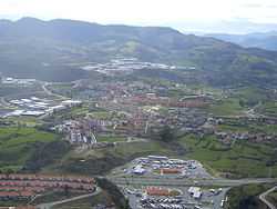
Gallarta, municipality's main ward | |||
| |||
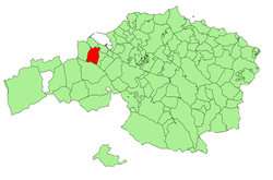 Location of Abanto-Zierbena in Biscay. | |||
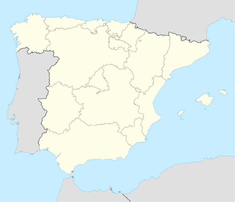 Abanto y Ciérvana / Abanto-Zierbena Location in Spain | |||
| Coordinates: 43°18′53″N 3°4′19″W / 43.31472°N 3.07194°WCoordinates: 43°18′53″N 3°4′19″W / 43.31472°N 3.07194°W | |||
| Country |
| ||
| Autonomous community |
| ||
| Province | Biscay | ||
| Comarca | Greater Bilbao | ||
| Government | |||
| • Alcalde | Manuel Tejada Lanbarri (EAJ-PNV) | ||
| Area | |||
| • Total | 18.03 km2 (6.96 sq mi) | ||
| Elevation | 128 m (420 ft) | ||
| Highest elevation | 540 m (1,770 ft) | ||
| Lowest elevation | 8 m (26 ft) | ||
| Population (2009) | |||
| • Total | 9,647 | ||
| • Density | 540/km2 (1,400/sq mi) | ||
| Demonym | abantarra | ||
| Time zone | CET (UTC+1) | ||
| • Summer (DST) | CEST (UTC+2) | ||
| Postal code | 48500 & 48540 | ||
| Official language(s) | Basque | ||
| Website | Official website | ||
- Not to be confused with Abanto in Aragón.
Abanto y Ciérbana-Abanto Zierbena is a municipality located in the province of Biscay, in the autonomous community of Basque Country, in the north of Spain.[1]
Neighborhoods
Abanto was originally divided into concejos, Susoko Abanto or Abanto de Suso and Yusoko Abanto or Abanto de Yuso, nowadays administratively divided into neighborhoods or wards:[2]
- Susoko Abanto
- Abanto (pop. 59)
- Campillo (pop. 32)
- Gallarta (town center, pop. 5,107)
- Balastera (pop. 68)
- Florida (pop. 9)
- Las Calizas (Pop. 44)
- Picón (pop. 21)
- Santa Juliana (pop. 146)
- Triano (pop. 52)
- Yusoko Abanto
- Cotorrio (pop. 154)
- Las Carreras (pop. 1,814)
- Las Cortes (pop. 7)
- El Once (pop. 3)
- Olabarrieta (Pop. 55)
- Murrieta (pop. 51)
- Putxeta (pop. 269)
- San Pedro Abanto (pop. 46)
- Sanfuentes (pop. 1,675)
List of mayors of Abanto-Zierbena, since 1842
- Urtarrila 1842 – Urtarrila 1843 Andres Jose San Martin
- Urtarrila 1843 - Uztaila 1843 Emeterio del Alisal
- Uztaila 1843 - Martxoa 1844 Benigno Ruiz Murga
- Martxoa 1844 – 1846/01/01 Jose Mª Aretxabaleta
- 1846/01/01 – 1847/01/03 Juan Francisco del Merro
- 1847/01/03 – 1850/01/01 Miguel Eskutza
- 1850/01/01 – 1854/01/01 Pablo de los Heros
- 1854/01/01 – 1854/10/02 Francisco Robledo
- 1854/10/02 – 1857/03/12 Jose Gonzalez El Cerro
- 1857/03/12 – 1859/01/01 Cosme Allende
- 1859/01/01 – 1861/01/01 Miguel Eskutza
- 1861/01/01 – 1865/01/01 Jose Aranguren
- 1865/01/01 – 1867/01/01 Ruperto Lexartza
- 1867/01/01 – 1869/01/01 Manuel Garai Laza
- 1869/01/01 - Martxoa 1872 Agapito Sasia
- Martxoa 1872 – Iraila 1873 Antonio Hurtado
- Iraila 1873 – Urtarrila 1874 Agustin Iarto
- Urtarrila 1874 – 1875/01/01 Antonio Eskutza (Errejidorea)
- 1875/01/01 – 1876/01/01 Maximino Uriarte
- 1876/01/01 – 1876/03/07 Manuel Chave (Behin-behinekoa)
- 1876/03/07 – 1876/04/11 Juan Angel Allende
- 1876/04/11 – 1877/04/01 Jose Antonio Eskutza
- 1877/04/01 – 1879/07/01 Mamerto Bermeosolo
- 1879/07/01 – 1881/07/01 Juan Angel Allende
- 1881/07/01 – 1885/07/01 Mariano Olabarria
- 1885/07/01 – 1890/01/01 Calisto Lopez
- 1890/01/01 – 1891/07/01 Eugenio Solano
- 1891/07/01 – 1894/01/01 Agustin Iza Errementeria
- 1894/01/01 - Urria 1900 Calisto Lopez
- 1900/11/03 – 1904/01/01 Agustin Iza Errementeria
- 1904/01/01 – 1906/01/01 Agustin Garmendia
- 1906/01/01 – 1910/01/01 Bernardo Ruiz Elizondo
- 1910/01/01 - Urtarrila 1912 Alejo Eguzkitzaga Bilbao
- Urtarrila 1912 - Urtarrila 1914 Manuel Asla
- Urtarrila 1914 – 1916/01/01 Jose Salcedo Zubaran
- 1916/01/01 – 1918/01/01 Luis Sanjines
- 1918/01/01 – 1920/01/01 Fabriciano Torrontegi
- 1920/01/01 – 1923/10/01 Antonio Pujana Meabe
- 1923/10/01 – 1924/03/26 Dionisio Ureta Balparda
- 1924/03/26 – 1930/03/12 Tomas Quintana Martin
- 1930/03/12 – 1931/01/31 Dionisio Ureta Balparda
- 1931/01/31 – 1931/04/15 Francisco Uribe Urioste
- 1931/04/15 – 1931/04/28 Nemesio Merodio Ramos (Behin-behinekoa)
- 1931/04/28 – 1934/11/14 Antonio Pujana Meabe
- 1934/11/14 – 1936/02/23 Jose Colon Laza
- 1936/02/23 – 1937/07/02 Antonio Pujana Meabe
- 1937/07/02 – 1938/02/09 Luis Sanjines Renovales
- 1938/02/09 – 1952/05/03 Jose Colon Laza
- 1952/05/03 – 1955/08/29 Eugenio Mendikote Mardones
- 1955/08/29 – 1959/12/05 Juan Ramon Sanchez-Serrano Mugika
- 1959/12/05 – 1964/08/26 Francisco Garaigordobil Barrutia
- 1964/08/26 – 1969/12/14 Tomas Alonso Garcia
- 1969/12/14 – 1974/09/10 Jose Antonio Romero Onaindia
- 1974/09/10 – 1979/04/19 Luis Andres Merodio Garcia
- 1979/04/19 – 1983/05/23 Francisco Puerto Balmisa
- 1983/05/23 - Uztaila 1987 Luis Mª Vallejo Lopez
- Uztaila 1987 – 1991/06/15 Francisco Puerto Balmisa
- 1991/06/15 - 1995 Luis Mª Vallejo Lopez
- 1995 - 2003 Juan Jose Mezkorta Puertollano
- 2003 - 2013 Manuel Tejada Lanbarri
- 2013 - karguan Maite Etxebarria Azpiolea
Demographics
| Historical population | ||
|---|---|---|
| Year | Pop. | ±% |
| 1900 | 8,337 | — |
| 1910 | 9,053 | +8.6% |
| 1920 | 9,679 | +6.9% |
| 1930 | 9,870 | +2.0% |
| 1940 | 9,576 | −3.0% |
| 1950 | 9,419 | −1.6% |
| 1960 | 11,340 | +20.4% |
| 1970 | 10,121 | −10.7% |
| 1981 | 9,490 | −6.2% |
| 1991 | 9,351 | −1.5% |
| 2000 | 8,989 | −3.9% |
| 2010 | 9,724 | +8.2% |
References
- ↑ Idoia Estornés Zubizarreta & Manu Castaño García. "Auñamendi Encyclopedia: Abanto y Ciérvana / Abanto-Zierbena" (in Spanish). Eusko Ikaskuntza. Retrieved 3 July 2010.
- ↑ Euskaltzaindia. "Euskal Onomastikaren Datutegia (EODA): Abanto" (in Basque). Euskaltzaindia. Retrieved 3 July 2010.
See also
| Wikimedia Commons has media related to Abanto-Zierbena. |