AN/FPS-35
|
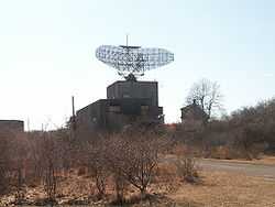
AN/FPS-35 Radar Tower and Antenna | |
 | |
|
The AN-FPS-35 Radar at Camp Hero State Park in Montauk, New York. The radar rises well above its surrounding trees. | |
| Nearest city | Montauk, New York |
|---|---|
| Coordinates | 41°3′44.81″N 71°52′28.24″W / 41.0624472°N 71.8745111°WCoordinates: 41°3′44.81″N 71°52′28.24″W / 41.0624472°N 71.8745111°W |
| Built | 1960 |
| Governing body | State |
| NRHP Reference # | 02000615 |
| Added to NRHP | June 4, 2002[1] |
The AN/FPS-35 radar was a long range radar used in the early 1960s.
Sperry Corporation built 12 long range radars (picking up objects 200 miles away) in the 1960s to succeed existing Semi Automatic Ground Environment (SAGE) to provide enhanced electronic countermeasures (ECM). The systems operated at 420 to 450 MHz. The antennas weighed 70 to 80 tons and had numerous problems. The concrete tower bases were 84 feet 6 inches (25.76 m) high and 60 feet 3 inches (18.36 m) square in side dimensions.
The prototype was developed at the Thomasville Aircraft Control and Warning Station in Thomasville, Alabama.[2] All of the radars have been dismantled except for the one at Camp Hero on the eastern tip of Long Island, New York. Fishermen on the Atlantic Ocean and Block Island Sound lobbied to save it since the massive radar tower was a better daytime landmark than the Montauk Point Lighthouse.[3]
The radar complex is now part of Camp Hero State Park which adjoins Montauk Point State Park. The radar has worked its way into an urban legend that it was used in time travel experiments called the Montauk Project.
The structure was listed on the National Register of Historic Places in 2002.[1][4]
The 85-foot concrete buildings that supported all of the FPS-35 antennas were prominent landmarks, and all remain presently standing.
- AL Thomasville 31°56′18″N 87°45′01″W / 31.9382°N 87.7502°W
- MI Sault St Marie 46°27′23″N 84°23′16″W / 46.4565°N 84.3878°W
- MI Selfridge 42°37′39″N 82°49′48″W / 42.6275°N 82.8300°W
- ND Finley 47°30′58″N 97°52′07″W / 47.5161°N 97.8687°W (steel tower, present)
- VA Manassas 38°37′44″N 77°26′19″W / 38.6288°N 77.4385°W
- OR Baker 44°35′11″N 117°47′14″W / 44.586389°N 117.787222°W (steel tower, demolished)
References
- ↑ 1.0 1.1 "National Register Information System". National Register of Historic Places. National Park Service. 2007-01-23.
- ↑ "AN/FPS-35". "Radomes.org". Retrieved 2008-01-08.
- ↑ Drumm, Russell (December 23, 1999). "Rally Round The Radar". The East Hampton Star. Retrieved 2009-10-12.
- ↑ Warren, James (February 2002). "National Register of Historic Places Registration: AN/FPS-35 Radar Tower and Antennae". New York State Office of Parks, Recreation and Historic Preservation. Retrieved 2008-07-28. Note: This includes "Accompanying 11 photos, undated". and "Accompanying nomination correspondence".
External links
| Wikimedia Commons has media related to AN/FPS-35. |