A4 motorway (Portugal)
| |
|---|---|
| Portuguese: Auto-estrada de Trás-os-Montes e Alto Douro | |
 | |
| Route information | |
| Length: | 63 km (39 mi) |
| Major junctions | |
| West end: | Matosinhos (Porto) |
| East end: | Amarante |
| Highway system | |
| Roads in Portugal | |

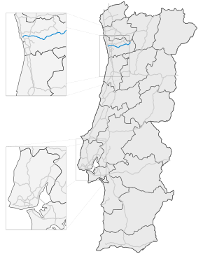
The A 4 is a Portuguese motorway which runs from Matosinhos to Amarante, with a length of 63 km, where it narrows to become signed as the IP road of which, by now, forms a part, IP4 .
The motorway leaves the metropolitan area of Porto, through the urban areas of Ermesinde, Valongo, Paredes, Penafiel, until arriving at the mountainous town of Amarante.
It is also known as one of the most dangerous motorways in the country, particularly the descent from Campo to Valongo. Many improvements are being projected by the government in this respect.
Currently the highway is being extended into Bragança and the border with Spain, to be opened in 2013, apart from the Túnel do Marão which will when completed be Portugal's longest road tunnel, cutting 5.6 km, through the Serra do Marão. The extension will also include a bridge which reaches an height from the ground of 230 m. Once extended the A4 will become Portugal's third longest motorway, with a length of 223 km (139 miles).
| ||||||||