A4 autostrada (Poland)
| |
|---|---|
 | |
| Route information | |
|
Part of | |
| Length: |
628.45 km (390.50 mi) 672 km (418 mi) planned |
| Major junctions | |
| From: |
|
|
| |
| To: |
border Poland-Ukraine at Korczowa-Krakovets - |
| Location | |
| Major cities: | Wrocław, Gliwice, Katowice, Kraków, Rzeszów |
| Highway system | |
| National roads in Poland | |

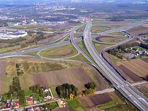
The autostrada A4 in Poland is a motorway which runs from west to east through southern Poland (longways Sudetes and Carpathian Mountains), from the Polish-German border at Zgorzelec-Görlitz (connecting to the German A4 autobahn), bypassing Wrocław, Opole, Gliwice, Katowice, Kraków, Tarnów, Dębica and Rzeszów to the Polish-Ukrainian border at Korczowa-Krakovets. The motorway is a part of the European route E40. As of October 30, 2014 about 628.45 km (390.50 mi) of the motorway have been completed, out of the planned total length of 672 km (418 mi). To complete the highway, one remaining section east of Rzeszów is currently under construction, and is scheduled to be finished in 2016.[1] The A4 parallels national road 94 (which connects with German Bundesstraße 6).
History of construction and plans for the future
Large stretches of this motorway were initially built as a Reichsautobahn by Nazi Germany in the 1930s. After the war, when the new borders placed them in Poland, they received minimal maintenance and upgrades, becoming notorious for the bad quality of their road surfaces, a phenomenon similar to that observed in East Germany. Extensive reconstruction, especially of the section between Legnica and Wrocław, has removed all traces of the old concrete road surface, but some aspects of 1930s standards of construction remain; for example, the aforementioned stretch does not have an emergency lane, a feature that is to be added in the future.
The section between Kraków and Katowice was built from the 1980s to 1996 and the section from Wrocław to Katowice between 2000 and 2005. In August 2009 construction of the last western part of the motorway from the border with Germany to the junction with A18 motorway was completed. Also, in 2009 the first part of the motorway east of Kraków (ending on national road 75 junction, near Szarów) was finished.
The original plan was to finish the rest of the motorway by about 2013, but because of the UEFA decision to host the 2012 UEFA European Football Championship in Poland and Ukraine and the resulting need for better road infrastructure connecting the two countries, the date for opening the motorway to traffic was moved up to June 2012. This ambitious target was not attained due to multiple delays encountered during construction, some caused by the floods of 2010.[2] The various subsections currently under construction will open in stages between second half of 2012 and 2016. Only the short section serving as the bypass of Rzeszów opened roughly on time in September 2012.
When finished in 2016, the A4 will be the first of the three major Polish motorways to be fully completed along its entire planned length.
Sections of the motorway
| Motorway section | Length | Constructed | Note |
|---|---|---|---|
| Jędrzychowice (border) - Zgorzelec | 1.7 km (1.1 mi) | 1994–1996 | heavy-load trucks only in 1994, all cars since 1996 |
| Zgorzelec - Krzyżowa | 50 km (31 mi) | 2007–2009 | opened 2009 |
| Krzyżowa - Bielany Wrocławskie | 99 km (62 mi) | 1933–1937 | repavement started in 90's finished 2006 without emergency lane |
| Bielany Wrocławskie - Przylesie(Brzeg) | 40.7 km (25.3 mi) | 1997–2000 | single carriageway motorway built in 1936-1938; tolls since 1 June 2012 |
| Przylesie(Brzeg) - Nogowczyce | 84.5 km (52.5 mi) | 2000–2003 | some construction before 1945; tolls since 1 June 2012 |
| Nogowczyce - Kleszczów | 17.9 km (11.1 mi) | 2001–2003 | single carriageway motorway built in 1936-1942, it continued from Kleszczów into Gliwice and today that section is National Road 88, while modern motorway bypasses Gliwice to the south; tolls since 1 June 2012 |
| Kleszczów - Katowice-Murckowska | 43 km (27 mi) | 1996–2005 | parts opened 1996 - 2005; Kleszczów - Gliwice-Sośnica part tolled since 1 June 2012 |
| Katowice-Murckowska - Balice | 60 km (37 mi) | 1983–1996 | opened in parts 1983-1996, private operator and tolls since 2000 |
| Balice - Szarów | 44 km (27 mi) | 1988–2009 | first sections signed as motorway in 2002 |
| Szarów - Tarnów | 57 km (35 mi) | 2010–2013 | opened to traffic in November, 2012, in part with single carriegeway only.[3] Both carriageways were fully opened in May, 2013.[4] |
| Tarnów Północ - Dębica Wschód [5] | 34.8 km (21.6 mi) | 2010–2014 | Opened Oct 30, 2014. Wisloka River viaduct (1.3 km) single carriageway only, the second carriageway opened a day later on Oct 31., 2014 [6] [7] |
| Dębica (interchange Dębica Wschód) - Rzeszów (Zachód)[8] | 37 km (23 mi) | 2010–2013 | opened in October, 2013 |
| Rzeszów (Zachód) - Rzeszów (Centralny) [9] | 4.0 km (2.5 mi) | 2010–2013 | opened in October, 2013 |
| Rzeszów (Centralny) - Rzeszów(Wschód) [10] | 6.9 km (4.3 mi) | 2010–2012 | opened in September, 2012 |
| Rzeszów(Wschód) - Jarosław[11] | 41.2 km (25.6 mi) | 2010–2016 | originally planned to finish in 2012, delayed until 2014, then contractor abandoned the contract in January 2014 when 70% complete due to dispute with the government over financing. New contract was awarded in September,[12] with construction beginning in October 2014, with completion planned for 2016.[13] |
| Jarosław - Radymno | 24.5 km (15.2 mi) | 2010–2013 | Jarosław Wschód - Radymno: opened in May, 2013; Jarosław Zachód - Jarosław Wschód: opened in December, 2013. |
| Radymno - Korczowa[14] | 22.6 km (14.0 mi) | 2010–2013 | originally planned to finish in 2012,[15] opened December 23, 2013 [16] |


.jpg)


Route description
| Route | |
| A 4 E 40 | |
| Border crossing PL-DE Jędrzychowice | |
| Zgorzelec | |
| Godzieszów | |
| Wykroty | |
| Bolesławiec | |
| Krzyżowa | |
| Krzywa | |
| Chojnów | |
| Złotoryja | |
| Nowa Wieś Legnicka | |
| Budziszów | |
| Kostomłoty | |
| Kąty Wrocławskie | |
| Pietrzykowice | |
| Wrocław-Południe | |
| Bielany Wrocławskie | |
| Krajków | |
| Brzezimierz | |
| Owczary | |
| Przylesie | |
| Prądy | |
| Dąbrówka | |
| Krapkowice | |
| Gogolin | |
| Olszowa | |
| Nogowczyce | |
| Łany | |
| Kleszczów | |
| Gliwice - Ostropa | |
| Gliwice - Bojków | |
| Gliwice - Sośnica | |
| Ruda Śląska - Wspólna | |
| Ruda Śląska - Wirek | |
| Chorzów - Batorego | |
| Katowice - Os. Witosa | |
| Katowice - Bocheńskiego | |
| Katowice - Mikołowska | |
| Katowice - Francuska | |
| Katowice - Murckowska | |
| Mysłowice | |
| Mysłowice - Brzęczkowice | |
| Jaworzno - Jeleń | |
| Chrzanów I | |
| Chrzanów II | |
| Chrzanów III | |
| Rudno | |
| Balice I | |
| Balice II | |
| Kraków - Mirowska | |
| Kraków - Tyniec | |
| Kraków - Sidzina | |
| Kraków - Opatkowice | |
| Kraków - Łagiewniki | |
| Kraków - Wieliczka | |
| Kraków - Bieżanów S7 | |
| Szarów | |
| Bochnia | |
| Brzesko | |
| Tarnów Zachód | |
| Tarnów Północ | |
| Dębica Zachód | |
| Dębica Wschód | |
| Ropczyce - Sędziszów | |
| Rzeszów Zachód | |
| Rzeszów Północ | |
| Rzeszów Wschód | |
| Łańcut (planned) | |
| Przeworsk (planned) | |
| Jarosław Zachód | |
| Jarosław Wschód | |
| Przemyśl | |
| Korczowa | |
| Border checkpoint PL-UA Korczowa | |
| M10 E 40 | |
See also
References
- ↑ Kolejne opóźnienia na budowie autostrady A4 na Podkarpaciu
- ↑ "Nowak: autostrad na Euro 2012 nie będzie".
- ↑ Budowa autostrady A4 pod Tarnowem na finiszu
- ↑ http://www.gddkia.gov.pl/pl/a/12401/Dwie-jezdnie-na-A4-miedzy-Brzeskiem-a-Wierzchoslawicami Dwie jezdnie na A4 między Brzeskiem a Wierzchosławicami
- ↑ GDDKiA info on A4 w. Krzyż - w. Dębica Pustynia
- ↑ http://www.gddkia.gov.pl/pl/a/16919/Dwoma-jezdniami-po-estakadzie-na-odcinku-A4-Tarnow-Debica
- ↑ http://wyborcza.biz/biznes/1,100896,16842239,Znamy_date_otwarcia_odcinka_A4_Tarnow___Debica_.html
- ↑ GDDKiA info on A4 w. Dębica Pustynia - w. Rzeszów Zachód
- ↑ GDDKiA info on A4 w. Rzeszów Zachód - w. Rzeszów Centralny
- ↑ GGDDKiA information page for A4 w. Rzeszów Centralny - w. Rzeszów Wschód
- ↑ GGDDKiA information page for A4 Rzeszów Wschód - Jarosław (w. Wierzbna)
- ↑
- ↑ Najkorzystniejsza oferta na A4 Rzeszów - Jarosław wybrana
- ↑ GGDDKiA information page for A4 Radymno - Korczowa
- ↑ Podkarpacie: Mobilizacja na budowie A4 Radymno – Korczowa
- ↑ Autostradą A4 do granicy - GDDKiA announcement
External links
| Wikimedia Commons has media related to Freeway A4 (Poland). |
| ||||||||||||||