A30 road
| |
|---|---|
 | |
| Route information | |
| Length: | 284 mi (457 km) |
| Major junctions | |
| East end: | Hounslow, London (51°28′30″N 0°23′46″W / 51.475°N 0.396°W) |
|
| |
| West end: | Land's End (50°03′58″N 5°42′04″W / 50.066°N 5.701°W) |
| Location | |
| Primary destinations: |
Staines-upon-Thames Basingstoke Salisbury Yeovil Honiton Exeter Okehampton Launceston Bodmin Redruth Penzance |
| Road network | |
The 284 miles (457 km) A30 road from London to Land's End, used to provide the most direct route from London to the south west; nowadays the M3 motorway and A303 road performs this function for much of the route and only parts of A30 now retain trunk road status. Places on the trunk section have been bypassed and sections of road widened.
Route
A30 London - Honiton
This section of the A30 passes through many towns and villages, including Staines-upon-Thames, Camberley, Basingstoke, Salisbury, Shaftesbury, Sherborne, Yeovil and Honiton.
The road starts near Hounslow at the junction with the A4 and runs along the south side of Heathrow Airport.
Much through traffic from the London area to south west England now uses the M3 motorway as far as Basingstoke then the A303 to Honiton where the route again joins the A30.
Between Basingstoke and Honiton, the A30 does not have trunk road status (except for short stretches around Salisbury, Shaftesbury and Yeovil) and is mostly single carriageway carrying local traffic.
Exeter to Penzance
This section is a major trunk road as far as Penzance.[1] It is mostly dual carriageway, but there are several short sections of single carriageway.
To pass Exeter, through traffic can join the M5 motorway for three miles. West of Exeter, the A30 is dual carriageway through Devon and into Cornwall, bypassing Whiddon Down, Okehampton and Launceston. The dual carriageway continues through Cornwall to Bodmin Moor, where there is a two-mile stretch of single carriageway. The dual carriageway resumes until Carland Cross, after which there is a single carriageway stretch to Chiverton Cross.
From Chiverton Cross, the dual carriageway bypasses Redruth and Camborne. The A30 returns to single-carriageway west of Camborne, and a mid-1980s bypass takes the road around Hayle. Between Hayle and Penzance, the A30 returns to the original route and it passes through several villages. Approaching Penzance, the A30 briefly becomes a dual-carriageway once again. Once west of Penzance, the A30 becomes a more rural road running through or past several villages, before terminating at Land's End.
| A30 (T) | |||||
| Eastbound exits | Junction name | Westbound exits | |||
|---|---|---|---|---|---|
| Dorchester A35 | – | Honiton A35 | |||
| Honiton A375 Heathpark |
– | Sidmouth A375 Cullompton (A373) | |||
| style="background: #ffdddd; color: black; vertical-align: middle; text-align: center; " class="table-no2" | No exit | – | Ottery St Mary, Fairmile, Feniton, Fenny Bridges B3177 | |||
| Fenny Bridges, Fairmile, Feniton B3177 | – | style="background: #ffdddd; color: black; vertical-align: middle; text-align: center; " class="table-no2" | No exit | |||
| Ottery St Mary, Whimple B3174 | – | Exmouth, Budleigh Salterton B3180 Ottery St Mary B3174 | |||
| Aylesbeare, Exeter Airport B3184 Clyst Honiton |
– | Exeter Airport B3184 Sowton Village, Clyst Honiton | |||
| Rockbeare, Sowton Village | – | style="background: #ffdddd; color: black; vertical-align: middle; text-align: center; " class="table-no2" | No exit | |||
| Start of A30 | M5 J29 | Plymouth, Torquay, Okehampton M5(S) Exeter A3015 Bristol, Taunton M5(N) | |||
| A30 concurrent with M5 | – | A30 concurrent with M5 | |||
| Taunton, Honiton, Exmouth M5 Plymouth A38 Torquay (A380) |
M5 J31 | Start of A30 End of M5 | |||
| Exeter A377 Honiton A30 avoiding motorway |
Alphington Junction | Exeter, Crediton A377 | |||
| Tedburn St Mary, Pathfinder Village | Fingle Glen | style="background: #ffdddd; color: black; vertical-align: middle; text-align: center; " class="table-no2" | No exit | |||
| Cheriton Bishop, Tedburn St Mary | Woodleigh Junction | Cheriton Bishop, Crockernwell, Drewsteignton, Fingle Bridge, Tedburn St Mary | |||
| Moretonhampstead A382 Torrington, Winkleigh (A3124) |
Whiddon Down | Moretonhampstead A382 Torrington, Winkleigh (A3124) | |||
| Okehampton B3260 | – | Okehampton B3260 | |||
| Okehampton B3260 | – | style="background: #ffdddd; color: black; vertical-align: middle; text-align: center; " class="table-no2" | No exit | |||
| Bideford, Tavistock, Plymouth A386 | Sourton Cross | Tavistock, Plymouth, Bideford A386 Holsworthy, Bude (A3079) | |||
| Broadwoodwidger, Bratton Clovelly, Stowford | Stowford Cross | Broadwoodwidger, Bratton Clovelly, Stowford | |||
| Polson A388 Liftondown, Lifton, Tinhay, Lewdown |
Liftondown | Tavistock (B3362) | |||
| Plymouth A388 (A38) Callington A388 Liskeard (A390) Tavistock (B3362) |
– | style="background: #ffdddd; color: black; vertical-align: middle; text-align: center; " class="table-no2" | No exit | |||
| Launceston, Holsworthy A388 Bude (B3254) |
Pennygillam | Launceston A388 Bude (B3254) Callington (A30, A388) Liskeard (A390) | |||
| style="background: #ffdddd; color: black; vertical-align: middle; text-align: center; " class="table-no2" | No exit | – | Tregadillett, Trebursye | |||
| Camelford, Tregadillett, South Petherwin A395 | – | Wadebridge, Camelford A395 (A39) | |||
| Trewint, Five Lanes, Altarnun | – | Five Lanes, Trewint, Altarnun | |||
| Bolventor, St Neot, St Cleer, Silbyback Lake | – | Bolventor, St Neot, St Cleer, Silbyback Lake | |||
| style="background: #ffdddd; color: black; vertical-align: middle; text-align: center; " class="table-no2" | No exit | – | Bodmin (A389) Liskeard A38 Lostwithiel (B3268) | |||
| Bodmin (A389) Liskeard, Plymouth A38 |
– | style="background: #ffdddd; color: black; vertical-align: middle; text-align: center; " class="table-no2" | No exit | |||
| Wadebridge A389 St Austell A391 |
– | Wadebridge A389 St Austell A391 | |||
| Victoria, Roche B3274 | Victoria Interchange | Roche, Victoria B3274 | |||
| Wadebridge A39 Newquay (A392) St Dennis (B3279) Indian Queens |
Highgate Hill | Newquay A39 (A392) Airport, St Columb, St Dennis (B3279) Indian Queens | |||
| Fraddon, Grampound Road, Ladock B3275 | – | Fraddon, Grampound Road, Ladock B3275 | |||
| Newquay, St Austell (A3058) | – | St Austell, Newquay (A3058) | |||
| Newquay A3076 | – | Newquay A3076 | |||
| Truro A39 | Carland Cross | Truro A39 Services | |||
| Zelah, Goonhavern, Shortlanesend | – | Goonhavern, Shortlanesend | |||
| Truro A390 St Agnes, Services B3277 Newquay A3075 |
Chiverton Cross | Truro A390 St Agnes, Services B3277 Newquay A3075 | |||
| Scorrier, Blackwater A3047 | – | Helston (B3297) Scorrier A3047 | |||
| Redruth, Scorrier A3047 | – | Redruth, Porthtowan | |||
| Camborne A3047 Portreath |
– | Pool, Camborne A3047 Portreath | |||
| Camborne A3047 | – | Camborne (West) A3047 | |||
| Hayle B3301 | – | Hayle B3301, Helston (B3302) | |||
| Hayle B3301 Helston (B3302) St Ives A3074 |
– | Hayle B3301 St Ives A3074 | |||
| Helston A394 | Newtown Roundabout | Helston A394 | |||
| – | Chy-an-Mor | – | |||
| Penzance B3311 | Branwell Lane | Penzance, Gulval B3311 | |||
| Treneere | – | Treneere | |||
| Madron, Heamoor West Cornwall Hospital |
– | Madron, Heamoor Penzance, West Cornwall Hospital | |||
| St Just A3071 Penzance Start of A30 (T) |
– | Penzance seafront St Just A3071 | |||
| 1.000 mi = 1.609 km; 1.000 km = 0.621 mi | |||||
History
The original route of the A30 went from Basingstoke to Salisbury via Andover, but was rerouted to Stockbridge on 1 April 1933. It originally ended in Penzance, being extended to Land's End in 1925.[2][3][4]
The 2.2-mile (3.5 km) long Honiton (£984,000) dual-carriageway bypass opened in early December 1966.[5] Between Honiton and Exeter, the A30 is dualled and at Exeter it merges briefly with the M5 motorway.
The A30 formerly ran through Exeter via Honiton Road to Heavitree Bridge, Fore Street Heavitree to Livery Dole, Heavitree Road to Paris Street. At the junction with High Street the A30 branched left and south-west and merged with the former A38 to Fore Street, New Bridge Street and Exe Bridge. At the west side of the bridge, the A38 branched left and south via Alphington Street, the A30 ran through Cowick Street, Dunsford Road and Pocombe Hill. At Pocombe Bridge, the A30 branched right and north to Tedburn St Mary.
The Okehampton bypass, which opened in the 1980s, skirts the northern edge of Dartmoor in Devon.
The Hayle bypass was built in the mid-1980s.

The section between Honiton and Exeter in East Devon was dualled in 1999 as a dual carriageway giving quicker access to Exeter International Airport. This road was built under the 'Design Build Finance Operate" scheme by the private consortium 'Connect A30', who funded its construction, and who receive a 'shadow toll' from the government for each vehicle that travels along this section of the road.[6] Archaeological investigations during the work found a Roman cavalry garrison and later settlement at Pomeroy Wood.[7]
There were many protests by environmentalists against the damage caused by the building of this road, and the particular nature of the DBFO scheme, with a long-lasting occupation of sites on the planned route, focused around the village of Fairmile. Swampy became well known for his part in this protest.
During 2006 one of the main bottlenecks on the road was removed when the Merrymeet roundabout between Okehampton and Exeter near Whiddon Down was replaced with a grade-separated junction and dual carriageway.[8]
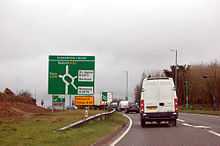
Since the Bodmin to Indian Queens project was completed in June 2007 the A30 is now virtually entirely dualled between Exeter and the A30/A39 junction at Carland Cross near Truro, apart from a short section across Bodmin Moor, near the village of Temple.
In late 2007 a new dual carriageway now runs around Goss Moor with the existing road converted to a cycle lane.[9]
Proposed developments
Other proposals
Two other improvements, Temple to Higher Carblake and Carland Cross to Chiverton Cross, were planned and would have created a continuous dual carriageway from Exeter to Camborne but these plans were shelved in 2006 as they were not considered a regional priority.[10] In December 2012 it was announced that the section from Temple to Higher Carblake would be upgraded to a dual carriageway.[11]
Goss Moor
In Cornwall the A30 previously crossed Goss Moor along a single carriageway section of the road between Victoria and Indian Queens. This was a major bottleneck in the county's transport system until 2007. An iron railway bridge is also situated in the middle of this section in which the Par–Newquay branch line crosses. This was built a long time before the road was dualled at both ends, and so can only fit a single carriage way beneath it. Due to its height (14 ft 3 in), many lorries in previous years had crashed into it, blocking the whole road completely.
There were plans to restore the rest of the St Austell – Indian Queens freight line (currently only going as far up as St Dennis), and direct rail traffic that way, but this plan was dropped. The road had been subject to a long-running campaign for expansion. As Goss Moor is a national nature reserve,[12] it is one of the most highly protected wildlife sites in the UK, and plans for expansion were strongly opposed.[13] In late 2004 a decision was finally reached, and a new dual carriageway now runs around the moor with the existing road converted to a cycle lane.[9] The first 4-mile (6.4 km) section of the new dual carriageway between Highgate Hill and the new Victoria Interchange opened at midnight on 9/10 May 2007. The former bottleneck of the iron bridge having now been eliminated means that problems with HGV lorries being stuck under the bridge should be a thing of the past. The remaining 3-mile (4.8 km) stretch of new dual carriageway between Victoria Interchange and Innis Downs roundabout opened on 25 June 2007.
The new dual carriageway means that average travel times along this section of the route have reduced significantly. Several petrol stations along the old route have now closed down, and the former route across Goss Moor is now silent once more. The remains of a Stone Age settlement were discovered along the new route during construction.[14]
References in popular culture
- John Betjeman immortalised the A30 in his poem "Meditation on the A30".
- Arthur Boyt, star of BBC documentary The Man Who Eats Badgers, described the A30 near Bodmin Moor as a good road for finding roadkill.[15]
- In Monty Python's Flying Circus, episode 34: The Cycling Tour, Mr Pither laments "As I lay down to the sound of the Russian gentlemen practising their shooting, I realised I was in a bit of a pickle. My heart sank as I realised I should never see the Okehampton by-pass again...", just before his impending execution in Russia. [16]
References
- ↑ "Area 1 (map)". Highways Agency. Retrieved 22 December 2011.
- ↑ "Half Inch Ministry of Transport Road Map". Ordnance Survey. Retrieved 22 December 2011.
- ↑ The National Archives File MT39/241 : "CLASSIFICATION : Numbering System"
- ↑ The National Archives File MT39/246 : "CLASSIFICATION : Renumbering of classified routes"
- ↑ "Honiton Bypass". Autocar. 125 (nbr 3696): page 1287. 16 December 1966.
- ↑ Highways Agency – A30 Exeter to Bere Regis
- ↑ "A30 Honiton to Exeter – Horse Power – Roman Style". Roads to the Past: Trunk Roads and Archaeology – 1999 report. Highways Agency. 1999. Retrieved 17 October 2009.
- ↑ Highways Agency – A30 Merrymeet Junction
- ↑ 9.0 9.1 "Moor dualling plans get go-ahead". BBC News. 29 November 2004. Retrieved 23 April 2010.
- ↑ "Winners and losers in roads plan". BBC News. 6 July 2006. Retrieved 23 April 2010.
- ↑ "AUTUMN STATEMENT 2012" (PDF). Retrieved 5 December 2012.
- ↑ Natural England – Special Sites
- ↑ Transport campaign group | A30 Goss Moor briefing | Foe cornwall
- ↑ "Stone age discovery in roadworks". BBC News. 6 September 2005. Retrieved 23 April 2010.
- ↑ "Arthur Boyt". Archived from the original on 5 December 2012. Retrieved 5 December 2012.
- ↑ http://www.ibras.dk/montypython/episode34.htm
| Wikimedia Commons has media related to A30 road (England). |
| |||||||||||||||||||||