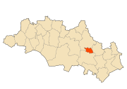
Aïn Beïda, Oum El Bouaghi
| Aïn Beïda عين البيضاء | |
|---|---|
| Commune and city | |
 | |
 Aïn Beïda | |
| Coordinates: 35°47′N 7°23′E / 35.783°N 7.383°E | |
| Country |
|
| Province | Oum El Bouaghi Province |
| District | Aïn Beïda District |
| Area | |
| • Total | 53.73 km2 (20.75 sq mi) |
| Elevation | 1,020 m (3,350 ft) |
| Population (2008 census) | |
| • Total | 116,064 |
| • Density | 2,200/km2 (5,600/sq mi) |
| Time zone | CET (UTC+1) |
| Postal code | 04201 |
Aïn Beïda is a city and municipality (baladiyah) located in Oum El Bouaghi Province, Algeria, south east of Constantine and north of Khenchla, inhabited by Chaouis. In 1998 its population was 88,300.[1]
Etymology
Aïn is Arabic and means spring, while Beïda means white. Thus, Aïn Beïda literally means "White spring". The "whiteness" refers to the purity of the water that springs from the said spring.
History
The town center still features a garden that houses Roman ruins, which indicates that the town has a long and rich history.
| Year | Population[1] |
|---|---|
| 1954 | 18,900 |
| 1966 | 30,800 |
| 1977 | 42,600 (town) 44,300 (municipality) |
| 1987 | 62,000 |
| 1998 | 88,300 |
| 2011 | 220,000 |
References
- ↑ 1.0 1.1 "Algeria (Djazaïria) historical demographic data". Populstat.