2015 Pacific typhoon season
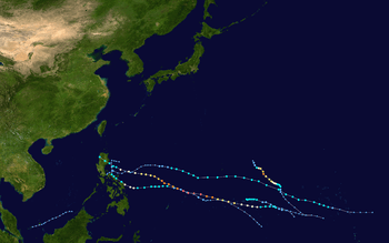 | |
| Season summary map | |
| First system formed | January 2, 2015 |
|---|---|
| Last system dissipated | Currently active |
| Strongest storm | Maysak – 905 hPa (mbar), 215 km/h (130 mph) (10-minute sustained) |
| Total depressions | 6 |
| Total storms | 5 |
| Typhoons | 2 |
| Super typhoons | 1 (unofficial) |
| Total fatalities | 12 total |
| Total damage | $16.3 million (2015 USD) |
| Pacific typhoon seasons 2013, 2014, 2015, 2016, 2017 | |
| Related article | |
The 2015 Pacific typhoon season is an ongoing event in the annual cycle of tropical cyclone formation, in which tropical cyclones form in the western Pacific Ocean. The season will run throughout 2015, though most tropical cyclones typically develop between May and October. The scope of this article is limited to the Pacific Ocean to the north of the equator between 100°E and 180th meridian. Within the northwestern Pacific Ocean, there are two separate agencies that assign names to tropical cyclones which can often result in a cyclone having two names. The Japan Meteorological Agency (JMA) will name a tropical cyclone should it be judged to have 10-minute sustained wind speeds of at least 65 km/h (40 mph) anywhere in the basin, whilst the Philippine Atmospheric, Geophysical and Astronomical Services Administration (PAGASA) assigns names to tropical cyclones which move into or form as a tropical depression in their area of responsibility located between 135°E and 115°E and between 5°N–25°N regardless of whether or not a tropical cyclone has already been given a name by the JMA. Tropical depressions that are monitored by the United States' Joint Typhoon Warning Center (JTWC) are given a number with a "W" suffix.
Seasonal forecasts
During each season, several national meteorological services and scientific agencies forecast how many tropical cyclones, tropical storms, and typhoons will form during a season and/or how many tropical cyclones will affect a particular country. These agencies include the Tropical Storm Risk (TSR) Consortium of the University College London, Philippine Atmospheric, Geophysical and Astronomical Services Administration (PAGASA) and the Taiwan's Central Weather Bureau.[1][2]
Season summary

2015 opened with Tropical Depression Jangmi (Seniang) located about 145 km (90 mi) to the northeast of Sandakan, Malaysia. The system subsequently moved south-eastwards and made landfall on Malaysia before dissipating later that day. A tropical depression subsequently developed to the northwest of Brunei during January 2, but did not develop any further and dissipated during January 4. The first tropical storm of the season was named Mekkhala during January 14 and went on to affect the Philippines and Pope Francis' visit to the Philippines. Less than a month later, Typhoon Higos had become the easternmost forming Pacific typhoon as well as being among the strongest February typhoons on record. Despite its intensity, Higos did not cause any significant effects over the landmasses and islands on the West Pacific. During the end of March, Typhoon Maysak formed and intensified into a Category 5 super typhoon, the strongest so far in the season and among the strongest prior to April.
Storms
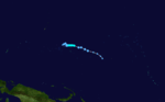
Severe Tropical Storm Mekkhala (Amang)
| Severe tropical storm (JMA) | |||
|---|---|---|---|
| Category 1 typhoon (SSHWS) | |||
| |||
| Duration | January 13 – January 20 | ||
| Peak intensity | 110 km/h (70 mph) (10-min) 975 mbar (hPa) | ||


On January 9, the JTWC started to monitor a weak tropical disturbance south-southwest of Pohnpei. During the next day, the system gained convective activity near the center, as the JMA upgraded the system to a tropical depression early on January 13.[3] At the same time, the JTWC issued a TCFA on the depression. Later that day, the JTWC followed suit, giving the designation 01W. The next day, the JMA upgraded 01W to a tropical storm, receiving the name Mekkhala, although the JTWC didn't upgrade it as it rapidly moved in a westerly direction.[4] On January 15, the PAGASA had reported that Mekkhala had entered the PAR, giving the local name Amang.[5][6][7] The next day, due to an increase of convection and some favorable environments, Mekkhala intensified to a severe tropical storm by the JMA. Later that day, the JTWC instead classified the storm to a minimal typhoon. The JMA followed suit early on January 17.[8] Later that day, land reaction occurred to the storm as both the JMA and JTWC downgraded it to a tropical storm the next day and started to move northwards. On January 18, Mekkhala encountered moderate vertical wind shear as both agencies made their final warning on the system. However, the JMA tracked the system until January 20.
Typhoon Higos
| Typhoon (JMA) | |||
|---|---|---|---|
| Category 4 typhoon (SSHWS) | |||
| |||
| Duration | February 6 – February 12 | ||
| Peak intensity | 165 km/h (105 mph) (10-min) 940 mbar (hPa) | ||

During February 4, the JTWC started to monitor a tropical disturbance, that had developed within an area marginal for further development near Kosrae.[9] Over the next couple of days the system gradually developed further and was classified as a tropical depression by the JMA during February 6. During the next day, the JMA reported that the depression had intensified into a tropical storm and named Higos.[10] The JTWC simultaneously upgraded the storm to Tropical Storm 02W as it started to intensify under favorable conditions. The next day, both agencies upgraded it to a minimal typhoon. On February 9, Higos underwent rapid deepening until it was classified a Category 4 typhoon according to the JTWC. Shortly after, however, stronger vertical wind shear and drier air quickly weakened Higos to a tropical depression.
At its peak Higos was the strongest Typhoon on record in February since 1970.[11]
Tropical Storm Bavi (Betty)
| Tropical storm (JMA) | |||
|---|---|---|---|
| Tropical storm (SSHWS) | |||
| |||
| Duration | March 10 – March 21 | ||
| Peak intensity | 85 km/h (50 mph) (10-min) 990 mbar (hPa) | ||

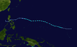
During March 8, the JTWC started to monitor a tropical disturbance that had developed, within a favourable environment for further development to the south east of Kwajalein in the Marshall Islands.[12] Over the next couple of days the system gradually developed further and was classified as a tropical depression by the JMA during March 10.[13][14] The JTWC followed suit on March 11, as they designated it as 03W. Later that day, the JMA upgraded 03W to a tropical storm, naming the system Bavi as its low-level circulation center became exposed for a brief period.[15] Bavi moved in a westerly direction until it reached peak intensity as a strong tropical storm on March 14. The next day, Bavi encountered unfavorable environments due to moderate to high vertical wind shear. On March 17, the PAGASA had reported that Bavi had entered their area, receiving the name Betty.[16][17] Later the same day, both agencies downgraded Bavi to a tropical depression as its center became exposed. On March 18, both the JMA and the JTWC made their final warning. The PAGASA finally downgraded the system to a low-pressure area on March 19. The JMA, however, tracked the system until March 23, when it dissipated west of Manila, Philippines.
Large waves coupled with high-tide caused flooding across the expansive Majuro Atoll in the Marshall Islands early in Bavi's development. A yacht struck a reef within the atoll due to the rough seas, though no injuries resulted. Gusty winds and heavy rain impacted much of the Marshall Islands.[18] Swells stemming from Bavi later affected parts of Kiribati which was still recovering from damaging king tides produced by Cyclone Pam.[19] On March 15, Bavi brought winds up to 100 km/h (65 mph) to the Mariana Islands, with Saipan and Tinian taking the brunt of the impact.[20] Many trees and power lines were downed across the islands, with Saipan temporarily losing all electricity service.[21] A total of 166 people sought refuge in public shelters on the island. Throughout the Marianas 5 homes were destroyed while a further 52 sustained damage. The Red Cross later provided more than $25,000 in assistance and funds to 252 people.[20]
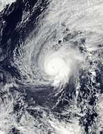
Typhoon Maysak (Chedeng)
| Typhoon (JMA) | |||
|---|---|---|---|
| Category 5 super typhoon (SSHWS) | |||
| |||
| Duration | March 26 – April 7 | ||
| Peak intensity | 215 km/h (130 mph) (10-min) 905 mbar (hPa) | ||


A day after Bavi dissipated, a low-pressure area formed southwest of Marshall Islands. It slowly drifted northwestward and became more organised over the next two days.[22] The next day, the JMA started tracking the system as a tropical depression.[23] On March 27, the JTWC started tracking the system as a tropical depression, and designated it 04W.[24] Moving west-northwestward, the system's center became more consolidated with convective banding becoming wrapped into it. The JTWC upgraded 04W to a tropical storm the same day.[25] The JMA followed suit later that day, when it was named Maysak.[26] On March 28, Maysak developed an eye,[27] and the JMA further upgraded it to a severe tropical storm.[28] The eye became more well defined with deep convection persisting along the southern quadrant of the storm. The overcast became more consolidated,[29] as the JMA upgraded Maysak to a typhoon on the same day.[30] On March 29, Maysak rapidly intensified over a period of 6 hours, attaining 1-min maximum sustained winds of 230 km/h (145 mph), making it a Category 4 equivalent on the SSHWS.[31] On the next day, Maysak further intensified into a Category 5-equivalent super typhoon. On April 1, the PAGASA stated tracking on the system, naming it as Chedeng.[32]
Typhoon Maysak passed directly over Chuuk State in the Federated States of Micronesia on March 29, causing extensive damage. High winds, measured up to 114 km/h (71 mph) at the local National Weather Service office, downed numerous trees, power lines, and tore off roofs. An estimated 80–90 percent of homes in Chuuk sustained damage. Power to most of the island was knocked out and communication was difficult. Early reports indicate that five people lost their lives.[33] A few days before Maysak made landfall, PAGASA stated that the country's official dry season had started.[34]
Tropical Storm Haishen
| Tropical storm (JMA) | |||
|---|---|---|---|
| Tropical storm (SSHWS) | |||
| |||
| Duration | April 3 – April 6 | ||
| Peak intensity | 65 km/h (40 mph) (10-min) 998 mbar (hPa) | ||

On April 1, the JTWC started to monitor a tropical disturbance over the Marshall Islands.[35] The system slowly intensified as it moved westwards and by April 3, the JMA classified the system as a weak tropical depression.[36] At the same time, the JTWC upgraded it to Tropical Depression 05W as it was over favorable environments with a good outflow surrounding the system.[37] The next day, the JTWC upgraded 05W to a tropical storm, while the JMA followed suit and named the storm Haishen.
Other storms
Early on January 2, the JMA reported that a tropical depression had developed to the northwest of Brunei, within an area that was marginally favourable for further development.[38][39] Over the next day the system moved into an area of moderate vertical wind shear, with atmospheric convection becoming displaced to the west of the fully exposed low level circulation centre.[40] The system was subsequently last noted by the JMA during January 4, as it dissipated in the South China Sea near the Malaysian-Indonesian border.[41][42][43]
Storm names
Within the North-western Pacific Ocean, both the Japan Meteorological Agency (JMA) and the Philippine Atmospheric, Geophysical and Astronomical Services Administration (PAGASA) assign names to tropical cyclones that develop in the Western Pacific, which can result in a tropical cyclone having two names.[44] The Japan Meteorological Agency's RSMC Tokyo — Typhoon Center assigns international names to tropical cyclones on behalf of the World Meteorological Organization's Typhoon Committee, should they be judged to have 10-minute sustained windspeeds of 65 km/h (40 mph).[45] While the Philippine Atmospheric, Geophysical and Astronomical Services Administration assigns names to tropical cyclones which move into or form as a tropical depression in their area of responsibility located between 135°E and 115°E and between 5°N-25°N even if the cyclone has had an international name assigned to it.[44] The names of significant tropical cyclones are retired, by both PAGASA and the Typhoon Committee.[45] Should the list of names for the Philippine region be exhausted then names will be taken from an auxiliary list of which the first ten are published each season. Unused names are marked in gray.
International names
Tropical cyclones are named from a set of five naming lists set by the JMA's Regional Specialized Meteorological Centre in Tokyo, Japan, once they reach tropical storm strength.[44] Names are contributed by members of the ESCAP/WMO Typhoon Committee. Each of the 14 nations and territories submitted ten names, which are used in alphabetical order, by the official English name of the country.[46] The next 24 names on the naming list are listed here along with their international numeric designation, if they are used.
|
|
|
|
Philippines
| Amang | Betty | Chedeng | Dodong (unused) | Egay (unused) |
| Falcon (unused) | Goring (unused) | Hanna (unused) | Ineng (unused) | Jenny (unused) |
| Kabayan (unused) | Lando (unused) | Marilyn (unused) | Nonoy (unused) | Onyok (unused) |
| Perla (unused) | Quiel (unused) | Ramon (unused) | Sarah (unused) | Tisoy (unused) |
| Ursula (unused) | Viring (unused) | Weng (unused) | Yoyoy (unused) | Zigzag (unused) |
| Auxiliary list | ||||
|---|---|---|---|---|
| Abe (unused) | Berto (unused) | Charo (unused) | Dado (unused) | Estoy (unused) |
| Felion (unused) | Gening (unused) | Herman (unused) | Irma (unused) | Jaime (unused) |
PAGASA uses its own naming scheme for tropical cyclones in their area of responsibility. PAGASA assigns names to tropical depressions that form within their area of responsibility and any tropical cyclone that might move into their area of responsibility. Should the list of names for a given year be exhausted, names will be taken from an auxiliary list, the first ten of which are published each year before the season starts. Names not retired from this list will be used again in the 2019 season. This is the same list used in the 2011 season, with the exception of Betty, Jenny, Marilyn, Perla and Sarah, which replaced Bebeng, Juaning, Mina, Pedring and Sendong. The name Betty was used for the first time.[47]
Season effects
This table will list all the storms that developed in the northwestern Pacific Ocean west of the International Date Line and north of the equator during 2015. It will include their intensity, duration, name, areas affected, deaths, and damage totals. Classification and intensity values will be based on estimations conducted by the JMA. All damage figures will be in 2015 USD. Damages and deaths from a storm will include when the storm was a precursor wave or an extratropical cyclone.
| Name | Dates active | Peak classification | Sustained windspeeds |
Pressure | Land areas affected | Damage (USD) |
Deaths | Refs |
|---|---|---|---|---|---|---|---|---|
| Tropical Depression | January 2 – 4 | Tropical depression | Not specified | 1006 hPa (29.71 inHg) | Brunei, Indonesia | None | None | |
| Mekkhala (Amang) | January 13 – 20 | Severe tropical storm | 110 km/h (70 mph) | 975 hPa (28.79 inHg) | Caroline Islands, Philippines | $7.8 million | 3 | [48][49] |
| Higos | February 6 – 12 | Typhoon | 165 km/h (105 mph) | 940 hPa (27.76 inHg) | Marshall Islands, Caroline Islands | None | None | |
| Bavi (Betty) | March 10 – 21 | Tropical storm | 85 km/h (50 mph) | 990 hPa (29.23 inHg) | Kiribati, Marshall Islands, Mariana Islands, Philippines | Minimal | None | |
| Maysak (Chedeng) | March 26 – April 7 | Typhoon | 215 km/h (130 mph) | 905 hPa (26.72 inHg) | Marshall Islands, Caroline Islands, Philippines, China | $8.5 million | 9 | |
| Haishen | April 3 – 6 | Tropical storm | 65 km/h (40 mph) | 998 hPa (29.47 inHg) | Caroline Islands | None | None | |
| Season Aggregates | ||||||||
| 6 systems | January 2 – Currently active | 215 km/h (130 mph) | 905 hPa (26.72 inHg) | $16.3 million | 12 | |||
See also
- 2015 Atlantic hurricane season
- 2015 Pacific hurricane season
- 2015 North Indian Ocean cyclone season
- South-West Indian Ocean cyclone seasons: 2014–15, 2015–16
- Australian region cyclone seasons: 2014–15, 2015–16
- South Pacific cyclone seasons: 2014–15, 2015–16
- South Atlantic tropical cyclone
References
- ↑ Ming-Dean Cheng (June 27, 2013). Two to Four Typhoons Tend to Impinge upon Taiwan during 2013 (.DOC). Weather Forecast Center (Report) (Taiwan: Central Weather Bureau). Retrieved October 1, 2013.
- ↑ Malano, Vicente B (January 10, 2014). January — June 2014 (Seasonal Climate Outlook). Philippine Atmospheric, Geophysical and Astronomical Services Administration. Archived from the original on May 7, 2014. Retrieved May 7, 2014.
- ↑ "Tropical Cyclone Advisory for Analysis and Forecast 2015-01-13T21:00:00Z". Japan Meteorological Agency. Retrieved January 12, 2015.
- ↑ "Guidance – Forecast Track by Numerical Weather Prediction 2015-01-14T06:00:00Z". Japan Meteorological Agency. Retrieved January 14, 2015.
- ↑ "Tropical storm amang enters PAR, fisher folk in parts of Luzon, Visayas warned". GMA News. January 15, 2015. Retrieved January 15, 2015.
- ↑ http://www.usno.navy.mil/NOOC/nmfc-ph/RSS/jtwc/warnings/wp0115.gif
- ↑ http://edition.cnn.com/2015/01/16/world/pope-philippines-visit-typhoon/index.html
- ↑ "Tropical Cyclone Prognostic Reasoning 2015-01-17T00:00:00Z". Japan Meteorological Agency. Retrieved January 17, 2015.
- ↑ Joint Typhoon Warning Center. "Significant Tropical Weather Advisory for the Western and South Pacific Oceans February 5, 2015 00z". United States Navy, United States Airforce. Archived from the original on February 5, 2015. Retrieved February 15, 2015.
- ↑ "Forecast Track by Numerical Weather Prediction 2015-02-07T18:00:00Z". Japan Meteorological Agency. Retrieved February 7, 2015.
- ↑ "Typhoon Higos Makes History in NW Pacific; Heavy Snow, Floods Pummel Southern Europe". Retrieved February 11, 2015.
- ↑ Joint Typhoon Warning Center. "Significant Tropical Weather Advisory for the Western and South Pacific Oceans March 8, 2015 23z". United States Navy, United States Airforce. Archived from the original on March 8, 2015. Retrieved March 22, 2015.
- ↑ "JMA WWJP25 Warning and Summary March 10, 2015 06z". Japan Meteorological Agency. March 10, 2015. Archived from the original on March 10, 2015. Retrieved March 22, 2015.
- ↑ "Special Weather Statement March 10, 2015 00z". NWS Guam. March 10, 2015. Archived from the original on March 10, 2015. Retrieved March 22, 2015.
- ↑ "Forecast Track by Numerical Weather Prediction 2015-03-11T18:00:00Z". Japan Meteorological Agency. Retrieved March 11, 2015.
- ↑ "Tropical Storm Bavi enters PAR, codenamed Betty". GMA News. Retrieved March 17, 2015.
- ↑ "Severe Weather Bulletin No.1 Tropical Storm BETTY (BAVI)" (PDF). NDRRMC. March 17, 2015. Retrieved March 17, 2015.
- ↑ "Marshalls battered by tropical depression". Radio New Zealand International. March 12, 2015. Retrieved April 4, 2015.
- ↑ Emergency Plan of Action (EPoA) Kiribati: Tropical Cyclone Pam (PDF). International Federation of Red Cross and Red Crescent Societies (Report) (ReliefWeb). March 16, 2015. Retrieved March 17, 2015.
- ↑ 20.0 20.1 "Red Cross provides assistance to families affected by Tropical Storm Bavi". Marianas Variety. March 27, 2015. Retrieved April 4, 2015.
- ↑ Ferdie De La Torre (March 16, 2015). "166 seek shelter as Bavi batters NMI". Retrieved April 4, 2015.
- ↑ "MEDIUM from ABPW10 2015-03-25". Joint Typhoon Warning Center. Retrieved 27 March 2015.
- ↑ "Tropical Depression (< 30kts) from JMA 2015-03-26". Japan Meteorological Agency. Retrieved 27 March 2015.
- ↑ "JTWC Warning 001 for TD 04W". JTWC. Retrieved 27 March 2015.
- ↑ "Prognostic Reasoning for Warning 003 on Tropical Storm 04W". Joint Typhoon Warning Center. Retrieved 27 March 2015.
- ↑ "Tropical Storm Maysak from JMA 2015-03-27". JMA. Retrieved 28 March 2015.
- ↑ "Prognostic Reasoning for Warning 007 of Tropical Storm Maysak". Joint Typhoon Warning Center. Retrieved 28 March 2015.
- ↑ "STS Maysak from JMA 281200". Japan Meteorological Agency. Retrieved 28 March 2015.
- ↑ "Prognostic Reasoning for Warning 008 on Typhoon Maysak". Joint Typhoon Warning Center. Retrieved 29 March 2015.
- ↑ "Typhoon Maysak from JMA 281800". Japan Meteorological Agency. Retrieved 29 March 2015.
- ↑ "Prognostic Reasoning for Warning 16 on Typhoon Maysak". JTWC. Retrieved 31 March 2015.
- ↑ "NDRRMC Update re Severe Weather Bulletin No. 01 Typhoon Chedeng" (PDF). NDRRMC. Retrieved April 1, 2015.
- ↑ Robert Q. Tupaz (March 31, 2015). "Chuuk hit hard by Typhoon Maysak". Marianas Variety. Retrieved March 31, 2015.
- ↑ "Dry season arrives ahead of oncoming storm". GMA News. Retrieved April 1, 2015.
- ↑ "TROPICAL DEPRESSION 05W (FIVE) WARNING NR 001". Joint Typhoon Warning Center.
- ↑ "WWJP25 RJTD 030000 WARNING AND SUMMARY 030000". Japan Meteorological Agency.
- ↑ "PROGNOSTIC REASONING FOR TROPICAL DEPRESSION 05W (FIVE) WARNING NR 01". Joint Typhoon Warning Center.
- ↑ "JMA WWJP25 Warning and Summary January 2, 2015 06z". Japan Meteorological Agency. January 2, 2015. Archived from the original on January 2, 2015. Retrieved January 2, 2015.
- ↑ Joint Typhoon Warning Center. "Significant Tropical Weather Advisory for the Western and South Pacific Oceans January 2, 2015 01z". United States Navy, United States Airforce. Archived from the original on January 2, 2015. Retrieved January 2, 2015.
- ↑ Joint Typhoon Warning Center. "Tropical Cyclone Formation Alert Cancellation January 3, 2015 06z". United States Navy, United States Airforce. Archived from the original on January 3, 2015. Retrieved January 5, 2015.
- ↑ Joint Typhoon Warning Center. "Significant Tropical Weather Advisory for the Western and South Pacific Oceans January 4, 2015 06z". United States Navy, United States Air force. Archived from the original on January 5, 2015. Retrieved January 2, 2015.
- ↑ "JMA WWJP25 Warning and Summary January 4, 2015 06z". Japan Meteorological Agency. January 4, 2015. Archived from the original on January 5, 2015. Retrieved January 5, 2015.
- ↑ "JMA WWJP25 Warning and Summary January 4, 2015 12z". Japan Meteorological Agency. January 4, 2015. Archived from the original on January 5, 2015. Retrieved January 5, 2015.
- ↑ 44.0 44.1 44.2 Padgett, Gary. "Monthly Tropical Cyclone Summary December 1999". Australian Severe Weather. Archived from the original on August 28, 2012. Retrieved October 1, 2013.
- ↑ 45.0 45.1 The Typhoon Committee (February 21, 2013). "Typhoon Committee Operational Manual 2013". World Meteorological Organization. pp. 37–38. Archived from the original (PDF) on August 28, 2012. Retrieved October 1, 2013.
- ↑ "Tropical Cyclone names". JMA. Archived from the original on April 2, 2008. Retrieved April 20, 2008.
- ↑ "Philippine Tropical Cyclone Names". Philippine Atmospheric, Geophysical and Astronomical Services Administration. Retrieved April 18, 2015.
- ↑ "SitRep No. 10 re Effects of Tropical Storm "Amang" (MEKKHALA)" (PDF). National Disaster Risk Reduction and Management Council. Retrieved January 20, 2015.
- ↑ Mar S. Arguelles (January 21, 2015). "Storm 'Amang' leaves 3 people dead, P318.7M in damages in Bicol". Philippine News Agency. Interaksyon. Retrieved March 24, 2015.
External links
| Wikimedia Commons has media related to 2015 Pacific typhoon season. |
- Japan Meteorological Agency
- China Meteorological Agency (Chinese)
- Digital Typhoon
- Hong Kong Observatory
- Joint Typhoon Warning Center
- Korea Meteorological Administration
- National Weather Service Guam
- Malaysian Meteorological Department
- Philippine Atmospheric, Geophysical and Astronomical Services Administration
- Taiwan Central Weather Bureau
- TCWC Jakarta (Indonesian)
- Thai Meteorological Department (Thai)
- Typhoon2000
- Vietnam's National Hydro-Meteorological Service
| ||||||
| |||||||||||||