2014 North Indian Ocean cyclone season
| |
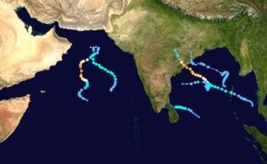
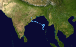
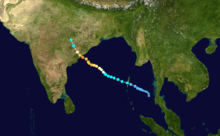
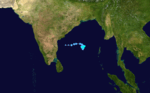
| Season summary map |
| First system formed |
January 4, 2014 |
| Last system dissipated |
November 8, 2014 |
| Strongest storm |
Nilofar – 950 hPa (mbar), 205 km/h (125 mph) (3-minute sustained) |
| Depressions |
8 |
| Deep depressions |
5 |
| Cyclonic storms |
3 |
| Severe cyclonic storms |
2 |
| Very severe cyclonic storms |
2 |
| Total fatalities |
147 total |
| Total damage |
At least $11 billion (2014 USD) |
North Indian Ocean tropical cyclone seasons
2012, 2013, 2014, 2015, Post-2015 |
The 2014 North Indian Ocean cyclone season was an event in the annual cycle of tropical cyclone formation. The season included two Very Severe Cyclonic Storms, both in October, and one other named cyclonic storm. Cyclone Hudhud is estimated to have caused over US$11 billion of economic damage in eastern India and Nepal, and more than 100 deaths.
The scope of this article is limited to the Indian Ocean in the Northern Hemisphere, east of the Horn of Africa and west of the Malay Peninsula. There are two main seas in the North Indian Ocean — the Arabian Sea to the west of the Indian subcontinent, abbreviated ARB by the India Meteorological Department (IMD); and the Bay of Bengal to the east, abbreviated BOB by the IMD.
The official Regional Specialized Meteorological Centre in this basin is the India Meteorological Department (IMD), while the Joint Typhoon Warning Center releases unofficial advisories. On average, four to six storms form in this basin every season.[1]
Season summary

Storms
Depression BOB 01
| Depression (IMD) |
| Tropical storm (SSHWS) |
|
|
| Duration |
January 4 – January 7 |
| Peak intensity |
45 km/h (30 mph) (3-min) 1004 mbar (hPa) |
Under the influence of an active Intertropical Convergence Zone (ITCZ), a low pressure system formed over the Bay of Bengal on January 2, slowly organizing as it moved into a favorable environment. A Tropical Cyclone Formation Alert (TCFA) was issued by the Joint Typhoon Warning Center (JTWC). On January 4, the India Meteorological Department (IMD) commenced its advisories on the storm, designating it Depression BOB 01, followed by the JTWC classifying the storm a tropical cyclone. The storm intensified a little further, before it made landfall over north Sri Lanka on January 6 and degenerating into a low pressure area during the following day.[2]
The storm brought moderate rainfall to northern Sri Lanka. On January 6, Vavuniya reported the highest amount of rainfall of 210 mm (8.3 in), followed by Puttalam, Anuradhapura and Trincomalee receiving 50 mm (2.0 in) each. The depression was the first storm to form in the month of January since 2005 in the North Indian Ocean.[2]
Depression BOB 02
| Depression (IMD) |
|
|
| Duration |
May 21 – May 23 |
| Peak intensity |
45 km/h (30 mph) (3-min) 1000 mbar (hPa) |
A low pressure area formed over the Bay of Bengal on May 19. It slowly consolidated, prompting IMD to classify it a Depression on May 21, followed by JTWC issuing a Tropical Cyclone Formation Alert (TCFA) in the following hours.[3][4] Over the following day, the depression continued moving north-northeastwards towards an area of high vertical wind shear. The JTWC cancelled the TCFA issued for the system, stating that high wind shear had caused the convection to start dissipating.[5] The storm continued losing convection, until it weakened into a well-marked low pressure area on May 23.[6] The remnant system persisted for several more days, moving over the Indian state of Odisha late on May 25, before dissipating on the following day.[7]
The depression brought much-needed relief to Odisha which had been suffering from a heat wave that claimed at least 22 lives. Coastal areas previously reporting temperatures near 40 °C (104 °F) fell below 30 °C (86 °F) during the system's passage.[8] Heavy rains affected many areas, including 208 mm (8.2 in) at Bhawanipatna which experienced temperatures of 45 °C (113 °F) days earlier. The highest 24‑hour rainfall was 210 mm (8.3 in) in Baleswar.[9] Six districts were placed under a flood alert due to the rains.[8] A bridge near Hatadahi in the Rayagada district was swept away by flooding.[9]
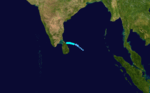
Cyclonic Storm Nanauk
| Cyclonic storm (IMD) |
| Tropical storm (SSHWS) |
|
|
| Duration |
June 10 – June 14 |
| Peak intensity |
85 km/h (50 mph) (3-min) 986 mbar (hPa) |
Under the influence of an active southwest monsoon surge, a low pressure area formed over the Arabian Sea on June 9. It slowly organized, and was classified tropical storm 02A by the JTWC in the early hours of June 10. In the following hours, the IMD upgraded the storm to a depression and subsequently a deep depression, designating it "ARB 01". On June 11, the system was upgraded to Cyclonic Storm intensity and was named Nanauk by the IMD as it continued to intensify under favorable environmental conditions. The following day, Nanauk reached its peak intensity with a minimum central pressure of 986 hPa (29.12 inHg) and 3-minute sustained winds of 85 km/h (53 mph). As it tracked further northwestwards, the storm encountered moderate vertical wind shear, dry air and low sea surface temperatures, causing it to weaken rapidly into a Depression on June 13. A low-level steering flow deflected the storm to take a northward path, and the system was last noted as a well-marked low pressure area on June 14.[10]
Land Depression 01
| Depression (IMD) |
|
|
| Duration |
July 21 – July 23 |
| Peak intensity |
45 km/h (30 mph) (3-min) |
A low pressure area formed over the Bay of Bengal on 20 July. It slowly moved northwestwards and rapidly consolidated into a Depression over northeast Odisha on 21 July.[11] The system slowly dissipated on the following day.
Deep Land Depression 02
| Deep depression (IMD) |
|
|
| Duration |
August 3 – August 7 |
| Peak intensity |
55 km/h (35 mph) (3-min) |
On 3 August, a low pressure area formed over the Bay of Bengal under the influence of an upper air cyclonic circulation.[12] The system slowly intensified into a depression the following day while being located inland over Midnapore. The depression moved further inland, underwent intensification and was upgraded to a deep depression the same day. The storm moved further westwards and weakened into a depression on August 5,[13][14] and was last noted as a well marked low pressure area on August 7 over northwestern Madhya Pradesh.
The storm activated a flood situation in Odisha, affecting 12 districts of the state. Waterlogging was reported in the cities of Cuttack and Bhubaneshwar, and nearly 200 villages were affected after Baitarani river swelled more than two meters over its flood danger level.[15] Sambalpur district received the highest amount of rainfall at 336.8 millimetres (13.26 in), followed by Balasore district receiving 226.4 millimetres (8.91 in).[16][17] Seven people were reported to be missing after two trawlers capsized off the coast.[18] The state government evacuated about 17,000 people from low lying areas. 23 deaths were reported due to torrential rainfall.[19]
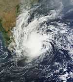
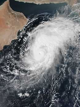
Very Severe Cyclonic Storm Hudhud
| Very severe cyclonic storm (IMD) |
| Category 4 tropical cyclone (SSHWS) |
|
|
| Duration |
October 7 – October 14 |
| Peak intensity |
185 km/h (115 mph) (3-min) 950 mbar (hPa) |
Main article:
Cyclone HudhudUnder the influence of an upper air cyclonic circulation, a low pressure area formed over Andaman Sea on October 6.[20] The system drifted westward and intensified into a depression and subsequently into a deep depression the next day, followed by the Joint Typhoon Warning Center (JTWC) issuing a Tropical cyclone formation alert (TCFA).[21] Owing to favorable environmental conditions, the storm intensified into a cyclonic storm on October 8 and was named Hudhud.[22][23] Its convection consolidated in the following hours, and Hudhud became a Severe Cyclonic Storm on October 9. Hudhud underwent rapid deepening in the following days, intensified into a Very severe cyclonic storm and developed a well-defined eye feature. Shortly before landfall near Visakhapatnam, Andhra Pradesh on October 12, Hudhud reached its peak strength with three minute wind speeds of 175 km/h (109 mph) and a minimum central pressure of 950 hPa (28.05 inHg).[24] The system drifted northwards over land and was last noted as a well-marked low pressure area over east Uttar Pradesh on October 14.[25]
Hudhud brought extensive damage to the coastal districts of Andhra Pradesh. At least 109 deaths were reported due to the storm, and the damage cost was amounted to $11 billion, making Hudhud the most damaging storm in the basin since Nargis in 2008.
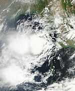
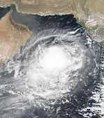
Very Severe Cyclonic Storm Nilofar
| Very severe cyclonic storm (IMD) |
| Category 4 tropical cyclone (SSHWS) |
|
|
| Duration |
October 25 – October 31 |
| Peak intensity |
205 km/h (125 mph) (3-min) 950 mbar (hPa) |
In late October, a low pressure area formed over the Arabian Sea. It slowly consolidated and a Tropical Cyclone Formation Alert (TCFA) was issued by the Joint Typhoon Warning Center (JTWC) on October 24.[26] The following day, the India Meteorological Department (IMD) classified the storm as a depression, designating it ARB 02, and the JTWC estimated tropical storm winds at the storm's center, starting advisories for the system.[27] On October 26, the system remained stationary and intensified into a Deep Depression. Subsequently, the IMD reported the storm had intensified into a cyclonic storm, and named it Nilofar.[28][29] The following day, the IMD upgraded the storm into a severe cyclonic storm and further to a very severe cyclonic storm, and the JTWC reported hurricane winds at Nilofar's center as it meanwhile developed an eye feature.[30][31][32] On October 28, Nilofar underwent rapid deepening throughout the day, reaching a peak strength of 950 mbar (28.05 inHg) with windspeeds exceeding 205 km/h (127 mph), tied with Hudhud. Over the following days, the storm recurved northeastwards and experienced high vertical wind shear, causing it to weaken rapidly into a minimal cyclonic storm on October 30. The low-level circulation center of the storm became exposed in the following hours and IMD downgraded the storm into a well-marked low pressure area on October 31, issuing its final advisory for the system.
Deep Depression BOB 04
| Deep depression (IMD) |
| Tropical storm (SSHWS) |
|
|
| Duration |
November 5 – November 8 |
| Peak intensity |
55 km/h (35 mph) (3-min) 1000 mbar (hPa) |
The JTWC started tracking an area of low pressure that formed in south-central Bay of Bengal, late on November 3. It slowly drifted northwards while deep convection persisted around the LLCC.[33] On November 5, the IMD identified the system as a depression and designated it with the identifier 'BOB 04'.[34] This was followed by the JTWC issuing a TCFA[35] and subsequently initiating advisories on the system. The JTWC designated it '05B' and was reporting 35 knots (65 km/h; 40 mph) winds around the center on November 6.[36] Later that day, the IMD upgraded BOB 04 into a Deep Depression.[37] The system drifted northwards over the next couple of days, maintaining intensity. Located between two subtropical ridges, BOB 04 mostly showed quasi-stationary motion.[38] However, albeit the adequately favorable conditions for further intensification, BOB 04 failed to intensify further. This resulted in the IMD downgrading the system into a Depression[39] and further into an area of low pressure by November 8.[40]
Season effects
This is a table of all storms in the 2014 North Indian Ocean cyclone season. It mentions all of the season's storms and their names, durations, peak intensities (according to the IMD storm scale), landfall(s) – denoted by bold location names – damages, and death totals. Damage and death totals include the damage and deaths caused when that storm was a precursor wave or extratropical low, and all of the damage figures are in 2014 USD.
See also
References
- ↑ "IMD Cyclone Warning Services: Tropical Cyclones".
- ↑ 2.0 2.1 India Meteorological Department. "A Preliminary Report on Depression over Bay of Bengal (4-7 January, 2014)". India Meteorological Department. Retrieved 10 May 2014.
- ↑ Regional Specialized Meteorology Center, New Delhi. "Depression BOB 02 Bulletin 1 issued at 0300 UTC on 21 May 2014". India Meteorological Department. Retrieved 21 May 2014.
- ↑ Joint Typhoon Warning Center. "Tropical Cyclone Formation Alert for the North Indian Ocean, issued at 0730 UTC of 22 May 2013.". Joint Typhoon Warning Center. Retrieved 23 May 2014.
- ↑ Joint Typhoon Warning Center. "Tropical Cyclone Formation Alert for North Indian Ocean on May 23, 2014, 0200 UTC". Joint Typhoon Warning Center. Retrieved 23 May 2014.
- ↑ Regional Specialized Meteorological Center, New Delhi. "Depression BOB 02 Bulletin 11, issued at 10:30 AM IST (0500 UTC), 23 May 2014". India Meteorological Department. Retrieved 23 May 2014.
- ↑ "Invest 92B Operational Best Track". Joint Typhoon Warning Center. United States Navy. May 27, 2014. Archived from the original (.TXT) on May 27, 2014. Retrieved May 29, 2014.
- ↑ 8.0 8.1 "Heavy Rains Lash Odisha; Flood Alert in 6 Districts". Bhubaneswar, India: The New Indian Express. May 26, 2014. Archived from the original on May 29, 2014. Retrieved May 29, 2014.
- ↑ 9.0 9.1 "Heavy rains create flood scare in Odisha". Bhubaneswar, India: Odisha Sun Times. May 26, 2014. Archived from the original on May 29, 2014. Retrieved May 29, 2014.
- ↑ India Meteorological Department. "RSMC New Delhi: Preliminary Report on Cyclonic Storm Nanauk". India Meteorological Department. Retrieved 22 June 2014.
- ↑ India Meteorological Department. "Tropical Weather Outlook for North Indian Ocean issued at 0600 UTC, 21 July 2014". Retrieved 21 July 2014.
- ↑ India Meteorological Department. "Tropical Weather Outlook for the North Indian Ocean issued on 3 August 2014 at 0600 UTC". Retrieved 4 August 2014.
- ↑ India Meteorological Department. "Information on Deep Depression over North Chattisgarh and Neighbourhood". Meteorological Center Bhubaneshwar. Retrieved 5 August 2014.
- ↑ India Meteorological Department. "All India Weather Bulletin (Evening), 5 August 2014". Retrieved 5 August 2014.
- ↑ "Baitarani wreaks havoc in Odisha, affects nearly 200 villages". Odisha Diary. Retrieved 5 August 2014.
- ↑ "Flood situation in Odisha become worse in 12 districts, 24 gates of Hirakud to be opened by noon". Odisha Diary. Retrieved 5 August 2014.
- ↑ "Odisha gears up to deal with food". The Hindu. Retrieved 5 August 2014.
- ↑ "Lost trawlers traced, seven missing". Deccan Herald. DHNS. Retrieved 5 August 2014.
- ↑ Singh, Neha (5 August 2014). "Flood Alert in Odisha: 23 Die of Torrential Rain, Evacuation in Progress". International Business Times. Retrieved 6 August 2014.
- ↑ "Tropical Weather Outlook for North Indian Ocean Issued at 0600 UTC of October 6, 2014". India Meteorological Department. Retrieved 7 October 2014.
- ↑ "Tropical Weather Outlook for North Indian Ocean Issued at 0600 UTC of October 7, 2014.". India Meteorological Department. Retrieved 7 October 2014.
- ↑ "Tropical Cyclone 03B (Three) Warning #01 Issued at 0300 UTC of October 8, 2014.". Joint Typhoon Warning Center. Retrieved 8 October 2014.
- ↑ "Cyclonic Storm, ‘HUD HUD’ over north Andaman Sea & adjoining southeast Bay of Bengal." (PDF). India Meteorological Department. Retrieved 8 October 2014.
- ↑ "Tropical Cyclone Hudhud Advisory 34 issued at 0700 UTC of 12 October 2014.". India Meteorological Department. Retrieved 12 October 2014.
- ↑ "BOB 03 Advisory 54 issued at 1300 UTC, October 14, 2014". India Meteorological Department. Retrieved 15 October 2014.
- ↑ "Tropical Cyclone Formation Alert WTIO21 Issued at 24 October 2014, 2200 UTC". Joint Typhoon Warning Center. Retrieved 25 October 2014.
- ↑ "Tropical Cyclone 04A (Four) Warning #01 Issued on 25 October 2014, 1500 UTC". Joint Typhoon Warning Center (JTWC). Retrieved 25 October 2014.
- ↑ "ARB 02 advisory 7 issued at 0600 UTC, 26 October 2014.". India Meteorological Department. Retrieved 26 October 2014.
- ↑ "Cyclonic Storm ‘NILOFAR’ over westcentral and adjoining southwest Arabian Sea. Pre-Cyclone Watch for north Gujarat coast" (PDF). India Meteorological Department. Archived from the original (PDF) on 26 October 2014. Retrieved 26 October 2014.
- ↑ "Severe Cyclonic Storm Nilofar Warning 14 issued at 0230 UTC, 27 October 2014.". India Meteorological Department. Retrieved 27 October 2014.
- ↑ "Very Severe Cyclonic Storm Nilofar Warning 16 issued at 0800 UTC of 27 October 2014.". India Meteorological Department. Retrieved 27 October 2014.
- ↑ "Tropical Cyclone 04A (Nilofar) Warning #07 Issued on 27 October 2014 at 0300 UTC.". Joint Typhoon Warning Center (JTWC). Retrieved 27 October 2014.
- ↑ "LOW from ABIO10 2014-11-04". Joint Typhoon Warning Center. Retrieved 11 November 2014.
- ↑ "Depression BOB04 from IMD 2014-11-05". India Meteorological Department. Retrieved 11 November 2014.
- ↑ "TCFA for Cyclone 05B". Joint Typhoon Warning Center. Retrieved 11 November 2014.
- ↑ "Warning NR001 - Cyclone 05B". Joint Typhoon Warning Center. Retrieved 11 November 2014.
- ↑ "Deep Depression BOB04 from IMD 2014-11-06". India Meteorological Department. Retrieved 11 November 2014.
- ↑ "Warning NR006 - Cyclone 05B". Joint Typhoon Warning Center. Retrieved 11 November 2014.
- ↑ "IMD National Bulletin BOB04/2014/11". India Meteorological Department. Retrieved 11 November 2014.
- ↑ "IMD National Bulletin BOB04/2014/15". India Meteorological Department. Retrieved 11 November 2014.
- ↑ "India: Damage from cyclone Hudhud likely to exceed $1 billion". 13 October 2014. Retrieved 13 October 2014.
- ↑ "Hudhud fallout: 9 more death cases; Vizag on road to normalcy". 15 October 2014. Retrieved 15 October 2014.
- ↑ "Cyclone Hudhud: 2 killed in Odisha, 68,000 people moved to safer places". 12 October 2014. Retrieved 12 October 2014.
- ↑ "Cyclone Hudhud impact: Heavy rain kills 18 in Uttar Pradesh". 15 October 2014. Retrieved 15 October 2014.
- ↑ "Nepal vows new safety rules for trekkers after deaths of 41 killed in blizzard, avalanches". 21 October 2014. Retrieved 22 October 2014.
External links
|
|---|
| | |
-
 Book Book
-
 Category Category
-
 Portal Portal
-
 WikiProject WikiProject
-
 Commons Commons
|
|
| 2010–2019 North Indian Ocean cyclone seasons |
|---|
| |
|