2013 Seddon earthquake
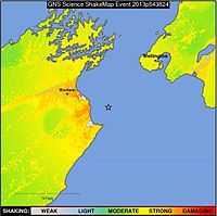
The 2013 Seddon earthquake measured 6.5 on the moment magnitude scale and was centred in New Zealand's Cook Strait, around 20 kilometres (12 mi) east of the town of Seddon in Marlborough. The earthquake struck at 5:09:30 pm on 21 July 2013 (05:09 UTC) at a depth of 17 kilometres (11 mi), according to Geonet.[2] The United States Geological Survey also measured the quake at 6.5, at an even shallower depth of 14 kilometres (8.7 mi).[3] The quake caused moderate damage in the wider Marlborough area and Wellington, the nation's capital city 55 kilometres (34 mi) north of the epicentre. Only minor injuries were reported. Several aftershocks occurred during 21–29 July.
The Seddon earthquake is considered the first of an earthquake doublet, with a second earthquake of similar magnitude occurred on 16 August 2013.
Earthquake
The mainshock followed a series of gradually increasing magnitude earthquakes from a sequence which began two days earlier:[5]
- Magnitude 5.7, 16 km depth, 19/07/2013
- Magnitude, 6.5 17 km depth, 21/07/2013
- Magnitude 5.8, 19 km depth, 21/07/2013
- Magnitude 5.3, 16 km depth, 21/07/2013
- Magnitude 5.0, 16 km depth, 21/07/2013
- Magnitude 4.9, 16 km depth, 21/07/2013
- Magnitude 4.9, 18 km depth, 21/07/2013
- Magnitude 4.8, 10 km depth, 22/07/2013
- Magnitude 4.8, 17m depth, 21/07/2013
- Magnitude 4.9, 10 km depth, 22/07/2013
[6]
Main aftershocks since 21 July 2013
Below is a list of all aftershocks of Richter,Moment & Body-wave Magnitudes 5.0 and above that have hit the Cook Strait since 16 August 2013 earthquake.[7]
| Date | Time | Richter Magnitude | Earthquake Epicentre | Depth (km) | Depth (miles) |
|---|
| 21 July 2013 | 5:13 pm | 5.2 | 30 km northeast of Seddon | 13 km | 8.1 miles |
| 22 July 2013 | 10:47 am | 5.0 | 15 km east of Seddon | 16 km | 9.9 miles |
| 29 July 2013 | 1:07 am | 5.4 | 20 km east of Seddon | 12 km | 7.5 miles |
| 16 August 2013 | 2:37 pm | 5.4 | 5 km southeast of Seddon | 9 km | 5.6 miles |
| 16 August 2013 | 2:45 pm | 5.4 | 10 km southeast of Seddon | 6 km | 3.7 miles |
| 16 August 2013 | 2:56 pm | 205 km east of Seddon | 5 km | 4.1 miles |
| 16 August 2013 | 3:09 pm | 5.5 | 10 km south of Seddon | 8 km | 5.0 miles |
| 16 August 2013 | 3:51 pm | 5.6 | 10 km east of Seddon | 19 km | 11.8 miles |
| 16 August 2013 | 5:31 pm | 6.0 | 15 km east of Seddon | 14 km | 8.7 miles |
| 16 August 2013 | 5:56 pm | 5.0 | 5 km northwest of Seddon | 10 km | 6.2 miles |
| 16 August 2013 | 6:42 pm | 5.2 | 20 km east of Seddon | 20 km | 12.4 miles |
| 16 August 2013 | 8:38 pm | 5.2 | 10 km southeast of Seddon | 22 km | 13.7 miles |
| 17 August 2013 | 4:13 pm | 5.0 | 15 km southwest of Seddon | 20 km | 12.4 miles |
| 17 August 2013 | 8:58 pm | 5.5 | 10 km south of Seddon | 20 km | 12.4 miles |
| 18 August 2013 | 4:07 am | 5.0 | 5 km southeast of Seddon | 20 km | 12.4 miles |
|
Damage
The quake resulted in varying degrees of damage to thirty-five buildings within the Wellington CBD with glass from broken windows falling onto the main thoroughfare of Lambton Quay. Damage was also caused in Paraparaumu, Wainuiomata, Porirua and the Hutt Valley in the North Island.[6][8]
The Wellington Region emergency management office was activated on the evening of 21 July, as were those in the lower part of the North Island.[6] On 22 July parts of Wellington's central business district were closed to the public to allow for inspections to buildings with damaged and potentially dangerous façades.[9]
Four people were injured in the quake, which lasted for 20 seconds, blowing out windows, cracking concrete and swaying buildings.[1]
See also
References
External links
|
|---|
| | February | |
|---|
| | March | |
|---|
| | April | |
|---|
| | May | |
|---|
| | June | |
|---|
| | July | |
|---|
| | August | |
|---|
| | September | |
|---|
| | October | |
|---|
| | November | |
|---|
|
- † indicates earthquake resulting in at least 30 deaths
- ‡ indicates the deadliest earthquake of the year
- Time for all earthquakes are in UTC
|
|
|
|---|
| | Pre-colonisation |
- 1100 Alpine Fault
- 1460 Wellington
- 1600s Alpine Fault
- 1717 Alpine Fault
- 1815 New Plymouth
- 1817 Fiordland
- 1826 Fiordland
- 1835 Manukau
- 1838 Waitotara Forest
|
|---|
| | Modern | |
|---|
| | Related articles | |
|---|
|