2005 North Indian Ocean cyclone season
| |
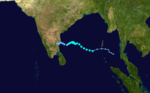
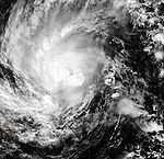
| Season summary map |
| First system formed |
January 7, 2005 |
| Last system dissipated |
December 22, 2005 |
| Strongest storm |
Fanoos – 998 hPa (mbar), 95 km/h (60 mph) (3-minute sustained) |
| Depressions |
12 official, 2 unofficial |
| Deep depressions |
7 official, 1 unofficial |
| Cyclonic storms |
3 official, 1 unofficial |
| Severe cyclonic storms |
1 |
| Total fatalities |
At least 1,227 direct, 4,000 missing |
| Total damage |
Unknown |
North Indian Ocean tropical cyclone seasons
2003, 2004, 2005, 2006, 2007 |
The 2005 North Indian Ocean cyclone season has no bounds, but cyclones tend to form between April and December, with peaks in May and November. These dates conventionally delimit the period of each year when most tropical cyclones form in the northern Indian Ocean.
The scope of this basin is limited to north of the Equator and west of the Malay peninsula. The IMD and JTWC monitor this basin. The Arabian Sea and Bay of Bengal make up this basin, abbreviated ARB and BOB, respectively.
Season summary
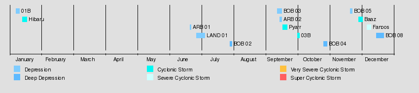
In 2005, a total of twelve cyclonic disturbances were identified in North Indian Ocean, against a normal of fifteen. However, it was highest after 1992. Four of them became cyclonic storm in Bay of Bengal and were named, against a normal of five to six.[1]
Storms
Tropical Depression 01B
| Tropical depression (SSHWS) |
|
|
| Duration |
January 7 – January 10 |
| Peak intensity |
55 km/h (35 mph) (1-min) 1000 mbar (hPa) |
In the second week of January, an area of convection persisted southeast of Sri Lanka. It organized into a tropical depression on January 8, but dissipated on the 10th due to vertical shear.
Cyclonic Storm Hibaru
| Cyclonic storm (IMD) |
| Tropical storm (SSHWS) |
|
|
| Duration |
January 13 – January 17 |
| Peak intensity |
65 km/h (40 mph) (3-min) 1000 mbar (hPa) |
Just behind the previous storm, a trough of low pressure developed into a tropical depression on January 13. Located a few hundred miles east-southeast of Sri Lanka, it meandered to the west, becoming a cyclonic storm on the 15th. Like its predecessor, Hibaru dissipated southeast of Sri Lanka on the 17th. This is the first season with two systems forming in January. The formation of a cyclonic storm in the month of January over low latitude is very rare; the last such occurrence was in the year 1987.
Depression ARB 01
| Depression (IMD) |
|
|
| Duration |
June 21 – June 22 |
| Peak intensity |
45 km/h (30 mph) (3-min) 992 mbar (hPa) |
Existed between June 21 and June 22, with MSW of 25 knots and pressure of 992 mb. Veraval in Gujarat recorded 70 mm rainfall from the Depression on 22 June 2005.[2]
Land Depression 01
| Depression (IMD) |
|
|
| Duration |
June 27 – July 5 |
| Peak intensity |
45 km/h (30 mph) (3-min) 990 mbar (hPa) |
A low pressure area formed over northwest Bay of Bengal on the morning of 27 June. It rapidly moved inland and concentrated into a depression over West Bengal close to Kolkata with MSW of 25 knots and pressure of 990 mb. Heavy rains from the depression caused flooding in India which killed at least 34 people.[3] Sagar in Madhya Pradesh got 480 mm rainfall on 4 July 2005.[2]
Deep Depression BOB 02
| Deep depression (IMD) |
|
|
| Duration |
July 29 – July 31 |
| Peak intensity |
55 km/h (35 mph) (3-min) 988 mbar (hPa) |
A monsoonal depression formed over the Bay of Bengal on July 29. The system reached its peak of 988 millibars (29.2 inHg) the following day, before weakening rapidly over Madhya Pradesh on July 31.[4]
Depression BOB 03
| Tropical depression (SSHWS) |
|
|
| Duration |
September 12 – September 16 |
| Peak intensity |
45 km/h (30 mph) (1-min) 992 mbar (hPa) |
Existed between September 12 and September 16 with MSW of 25 knots and pressure of 992. The system crossed Orissa coast near Paradip around 12 September. In 48hrs Nowrangpur in Orissa got 470 mm rainfall on 12 & 13 September 2005.[2]
Depression ARB 02
| Tropical depression (SSHWS) |
|
|
| Duration |
September 14 – September 16 |
| Peak intensity |
45 km/h (30 mph) (1-min) 996 mbar (hPa) |
A low pressure area formed over south Gujarat coast and concentrated into a depression on 14 September. The system crossed north Saurashtra coast in Gujarat, north of Porbandar around the midnight of 16 September. Palanpur in Gujarat got 90 mm on 15 September.[2]
Cyclonic Storm Pyarr
| Cyclonic storm (IMD) |
|
|
| Duration |
September 17 – September 21 |
| Peak intensity |
75 km/h (45 mph) (3-min) 988 mbar (hPa) |
An area of convection developed in the South China Sea on September 12. It moved west-northwestward, moving inland over Thailand on the 13th. It reached the Bay of Bengal on the 15th, and slowly developed. On September 17 it was upgraded to a tropical depression by the Indian Meteorological Department (but not by the JTWC), and on September 18 it became Cyclonic Storm Pyarr. The next day Pyarr made landfall as cyclonic storm close to Kalingapatnam in the state of north coastal Andhra Pradesh and on September 22 it dissipated over northwestern India. On 20 September, Kunavaram and Koida in Andhra Pradesh got very heavy rainfall of 490 and 480 mm in 24 hrs. One death was reported and the flooding caused Rs.50.30 crores in damages.[2]
Tropical Storm 03B
| Cyclonic storm (IMD) |
| Tropical Storm (SSHWS) |
|
|
| Duration |
October 1 – October 3 |
| Peak intensity |
75 km/h (45 mph) (3-min) 994 mbar (hPa) |
Tropical Storm 3B, which formed on October 2, hit Bangladesh on the 3rd as a 40 mph (64 km/h) tropical storm.
Deep Depression BOB 04
| Deep depression (IMD) |
| Tropical storm (SSHWS) |
|
|
| Duration |
October 26 – October 29 |
| Peak intensity |
55 km/h (35 mph) (3-min) 998 mbar (hPa) |
A low pressure area which formed over Southwest and adjoining Southeast Bay of Bengal on 25 October and concentrated into a depression the next day. The system crossed the coast close to Ongole in Andhra Pradesh on 28 October.[2]
Heavy rains from the storm caused significant flooding in India. At least 100 people were killed, 50,000 were evacuated, and over 100,000 others were affected.[5] The city of Chennai in Tamil Nadu also got very heavy rains of 423 mm on 27 October.[6]
Depression BOB 05
| Depression (IMD) |
|
|
| Duration |
November 20 – November 22 |
| Peak intensity |
45 km/h (30 mph) (3-min) 1002 mbar (hPa) |
A low pressure area formed in Bay of Bengal on 19 November. It moved in a west-northwesterly direction concentrated into a depression crossed Sri Lanka coast on 22 November. In 72 hrs between 22 and 24 November, Panruti in Tamil Nadu got heavy rainfall of 690 mm.[2][7]
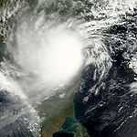
Cyclonic Storm Baaz
| Cyclonic storm (IMD) |
| Tropical storm (SSHWS) |
|
|
| Duration |
November 28 – December 2 |
| Peak intensity |
85 km/h (50 mph) (3-min) 998 mbar (hPa) |
The Joint Typhoon Warning Center issued a Tropical Cyclone Formation Alert early on November 27 on a low pressure system with persistent convection around its center not far from the Andaman Islands in the Bay of Bengal. At 2100Z that same day, about 100 n mi west of Port Blair, the JTWC upgraded the low pressure to a tropical depression, with the Indian Meteorological Department following suit the next day. It was upgraded into a tropical storm on the JTWC's following advisory at 0900Z on November 28. On November 28, the official RSMC in New Delhi upgraded the tropical storm to Baaz. The storm eventually dissipated as a significant tropical cyclone over sea near or north of Chennai. Baaz refers to the saker falcon in Arabic. Tambaram a suburb of Chennai city in the state of Tamil Nadu got heavy rainfall of 310 mm on 3 December. Eleven deaths were reported due the heavy flooding caused by Baaz.[2]
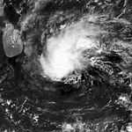
Severe Cyclonic Storm Fanoos
| Severe cyclonic storm (IMD) |
| Tropical storm (SSHWS) |
|
|
| Duration |
December 6 – December 10 |
| Peak intensity |
95 km/h (60 mph) (3-min) 998 mbar (hPa) |
Tropical Storm 06B formed 550 nautical miles (1,020 km) east of Chennai on December 6, west of the Andaman Islands. It became Cyclonic Storm Fanoos on December 7. However, Fanoos weakened into a deep depression prior to crossing north Tamil Nadu coast near Vedaranyam at 0530 UTC (1100 IST) December 10. Fanoos weakened further into a low pressure area over south Tamil Nadu coast next day. Its remnants entered Arabian Sea but regeneration did not occur. Fanoos means chandelier in Urdu.
Severe damage was reported in Sri Lanka where thousands of homes were either damaged or destroyed. Due to the quick weakening prior to landfall, only minor damage occurred in Tamil Nadu. However, heavy rains forced the evacuation of 30,000 residents in the area. On 11 December, Ramanathapuram in Tamil Nadu got heavy rainfall of 350 mm.[2] No fatalities were reported from Fanoos.[8]
Deep Depression BOB 08
| Deep depression (IMD) |
| Tropical storm (SSHWS) |
|
|
| Duration |
December 15 – December 22 |
| Peak intensity |
55 km/h (35 mph) (3-min) 1000 mbar (hPa) |
A depression formed over Southeast Bay of Bengal on December 15. On December 17 it was recognised by the JTWC when it was 220-nautical-mile (410 km) east of Colombo, Sri Lanka. The system weakened into an area of low pressure over water on December 22. The city of Chennai got around 60 mm rainfall on 19 December.
See also
References
External links
|
|---|
| | | |
-
 Book Book
-
 Category Category
-
 Portal Portal
-
 WikiProject WikiProject
-
 Commons Commons
|
|
| 2000–2009 North Indian Ocean cyclone seasons |
|---|
| |
|