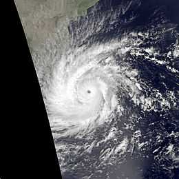
1978 Sri Lanka cyclone
| Very severe cyclonic storm (IMD scale) | |
|---|---|
| Category 3 (Saffir–Simpson scale) | |
 Cyclone 04B at peak intensity | |
| Formed | November 16, 1978 |
| Dissipated | November 24, 1978 |
| Highest winds |
3-minute sustained: 140 km/h (85 mph) 1-minute sustained: 205 km/h (125 mph) |
| Lowest pressure | 953 mbar (hPa); 28.14 inHg |
| Fatalities | About 1000 died, |
| Areas affected | Eastern Province, Sri Lanka |
| Part of the Pre-1980 North Indian Ocean cyclone seasons | |
The 1978 cyclone in Eastern province (JTWC designation: 04B) was the strongest tropical cyclone to strike Eastern province of Sri Lanka on November 23, 1978.[1] The cyclone was started at local time 6.30 pm and continued to next day morning and damaged the areas from Trincomalee to Arugam bay. In eastern province, Akkaraipattu, Ninthavur, Kalmunai, Pattiruppu, Chettipalayam, Thalankudah, Kattankudy, Batticaloa, Eravur and Kalkudah were most affected area due to cyclone’s vortex zone.[2]
Due to the cyclone, approximately a thousand persons died, more than one million people affected, nearly 250,000 houses partially and completely damaged, 240 school buildings damaged, one fifth of Batticaloa's fishing fleet smashed up, 9 of the 11 paddy stores destroyed, 90 percent of the coconut plantation (28,000 odd acres of coconut plantation) in the Batticaloa district destroyed. Government had spent over LKR 600 million in order to response to the disaster. A post cyclone survey found that approximately 130 miles of electric cables were laid, so many religious building were destroyed or damaged. The cyclone resulted to people suffer without electricity, water and debris of fallen buildings, trees, etc.[3][4] TIROS-N was observation satellite during the disaster and it was able to inform and to capture images.
References
- ↑ "Disaster Profile - Sri Lanka". Retrieved 10 May 2014.
- ↑ Neelavannan (1979). 12 மணி நேரம் (The 12 hours). Jaffna, Sri Lanka. p. 29.
- ↑ Disaster Incident in Sri Lanka
- ↑ Batticaloa's blackest day