1972 Atlantic hurricane season
| |
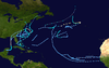
| Season summary map |
| First system formed |
May 23, 1972 |
| Last system dissipated |
November 7, 1972 |
| Strongest storm |
Betty – 976 mbar (hPa) (28.83 inHg), 105 mph (165 km/h) (1-minute sustained) |
| Total depressions |
19 |
| Total storms |
7 |
| Hurricanes |
3 |
| Total fatalities |
122 |
| Total damage |
$2.1 billion (1972 USD) |
Atlantic hurricane seasons
1970, 1971, 1972, 1973, 1974 |
| Related article |
|
|
The 1972 Atlantic hurricane season had only four fully tropical named storms – the fewest since 1930. It officially began on June 1, 1972, and lasted until November 30, 1972. These dates conventionally delimit the period of each year when most tropical cyclones form in the Atlantic basin. The first storm, Subtropical Storm Alpha, developed on May 23 off the Southeast United States and struck Florida, causing minor damage and two fatalities. Although several other tropical depressions developed, only Tropical Depression Five is known to have affected land.
The most significant storm of the season was Hurricane Agnes, which at the time was among the ten costliest United States hurricanes. After brushing the western tip of Cuba, the hurricane made landfall on the Florida Panhandle. It caused at least $2.1 billion (1972 USD) in damage and 128 fatalities, mostly from inland flooding in Pennsylvania and New York. The strongest hurricane of the season was Betty, which reached peak winds of 105 mph (165 km/h) while west of the Azores. Tropical Storm Carrie passed just offshore of Massachusetts, causing heavy rainfall, resulting in four fatalities, but only $1.78 million (1972 USD) in damage.
The remaining tropical systems – Dawn, Charlie, and Delta – caused no significant effects on land. A strong El Niño kept hurricane activity at a minimum, with only four tropical storms, four subtropical storms, and three hurricanes. It was also one of only five hurricane seasons since 1944 to have no major hurricanes – the other years being the 1968 season, the 1986 season, the 1994 season, and the 2013 season. In addition, the season was the first to name subtropical storms, using the Phonetic Alphabet, rather than the standard naming list.
Storms
Subtropical Storm Alpha
| Subtropical storm (SSHWS) |
|
|
| Duration |
May 23 – May 29 |
| Peak intensity |
70 mph (110 km/h) (1-min) 991 mbar (hPa) |
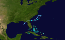
Subtropical Storm Alpha developed from a cold-core (extratropical) low in late May off the Florida coast. As the low moved northeastward, it warmed a little, and became Subtropical Depression One. It turned sharply southward on May 26 due to a building ridge of high pressure. The same day it became Subtropical Storm Alpha, and it moved toward the Georgia coast. After reaching its peak of 70 mph (110 km/h), Alpha weakened, but managed to hit near Brunswick, Georgia as a 45 mph (72 km/h) subtropical storm. Alpha dissipated over the northeastern Gulf of Mexico on May 29.
Alpha was the first named subtropical storm.
Hurricane Agnes
| Category 1 hurricane (SSHWS) |
|
|
| Duration |
June 14 – June 23 |
| Peak intensity |
85 mph (140 km/h) (1-min) 977 mbar (hPa) |
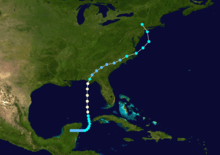
A polar front and an upper trough over the Yucatán Peninsula and eventually spawned a tropical depression by June 14. The storm emerged into the western Caribbean Sea on June 15, and by the following day, it strengthened Tropical Storm Agnes. The storm curved northward and brushed western Cuba on June 17. Agnes continued to intensify, and on June 18, it was upgraded to a hurricane. Minimal fluctuations in intensity occurred before the storm made landfall near Panama City, Florida on June 19. After moving inland, Agnes rapidly weakened and was only a tropical depression when it entered Georgia. Thereafter, weakening slowed as the storm crossed over Georgia and into South Carolina. However, while over eastern North Carolina on June 21, Agnes re-strengthened into a tropical storm, as a result of baroclinic activity. Early the following day, the storm emerged into the Atlantic Ocean before re-curving northwestward and making landfall near New York City as a strong tropical storm. Agnes quickly merged with a non-tropical low pressure system on June 23.[1]
Though it moved slowly across the Yucatán Peninsula, damage in Mexico is unknown. Heavy rainfall occurred in Cuba, killing seven people. In Florida, Agnes caused a significant tornado outbreak, with at least 26 confirmed twisters, though two of which were spawned in Georgia. The tornadoes alone resulted in over $4.5 million (1972 USD) in damage and six fatalities. At least 2,082 structures in Florida suffered either major damage or were destroyed. About 1,355 other dwellings experienced minor losses. Though Agnes made landfall as a hurricane, no hurricane force winds were reported. Abnormally high tides resulted in extensive damage, especially between Apalachicola and Cedar Key. In Georgia, damage was limited to two tornadoes, which caused approximately $275,000 (1972 USD) in losses. Minimal effects were also recorded in Alabama, Connecticut, Delaware, Rhode Island, South Carolina, and Tennessee; though one fatality was reported in Delaware. The most significant effects, by far, occurred in Pennsylvania, mostly due to severe flooding. In both Pennsylvania and New Jersey combined, about 43,594 structures were either destroyed or significantly damaged. In Canada, a mobile home was toppled, killing two people. Overall, Agnes caused 128 fatalities and nearly $3 billion (1972 USD) in damage, though more recently, it is estimated that there were $2.1 billion (1972 USD) in losses associated with the storm.
Hurricane Betty
| Category 2 hurricane (SSHWS) |
|
|
| Duration |
August 22 – September 1 |
| Peak intensity |
105 mph (165 km/h) (1-min) 976 mbar (hPa) |
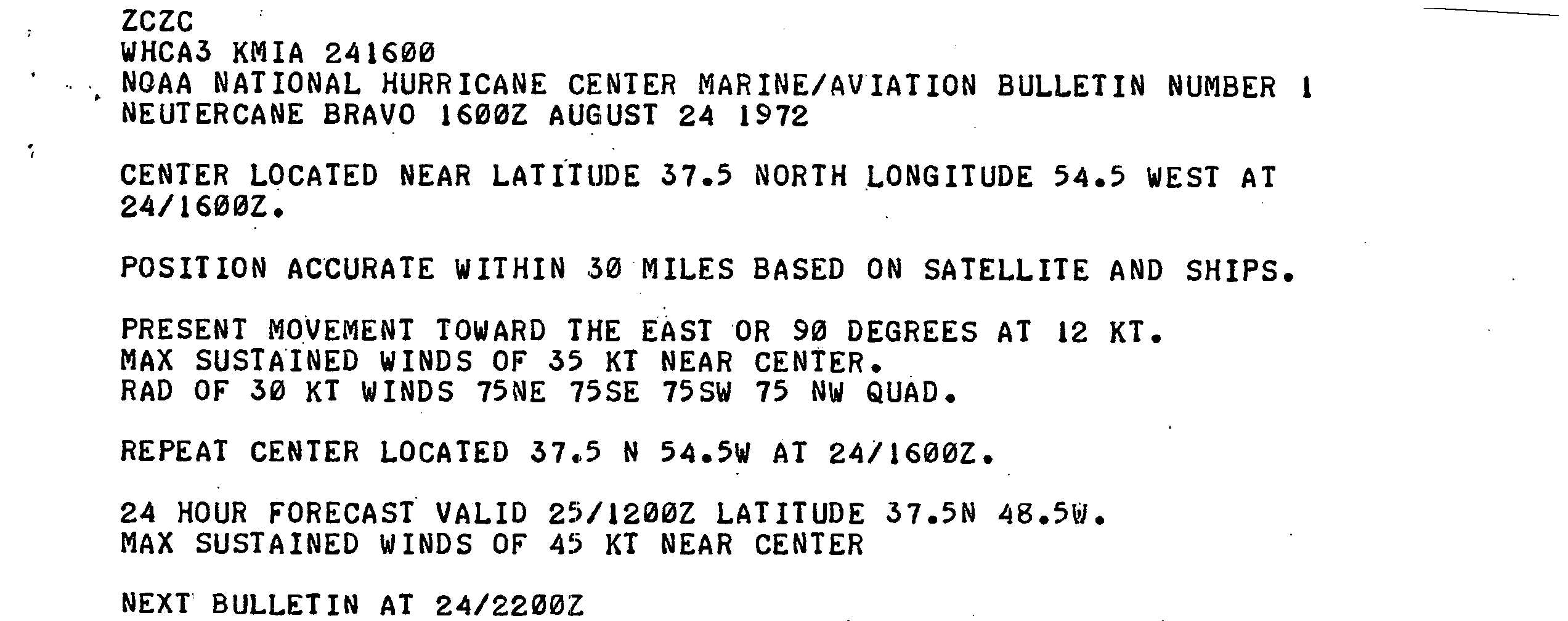
An area of disturbed weather appeared on satellite imagery while developing within an old frontal zone on August 21. At 1200 UTC on the following day, the SS Visurgis recorded winds of 40 mph (64 km/h). As a result, it is estimated that a subtropical depression developed while located about 290 miles (470 km) north-northeast of Bermuda. The subtropical depression strengthened slowly as it headed east-northeastward or eastward[1] and by August 24, the National Hurricane Center began classifying it as "Neutercane Bravo",[2] rather than Subtropical Storm Bravo. During the next 24 hours, minimal further intensification occurred, however, on August 25, a deepening high-level trough and a building ridge enhanced outflow and deep convection. Additionally, reconnaissance aircraft flights began indicating a transition to a warm-core. Unfavorable northwesterly winds briefly halted further development, though by late on August 26, Bravo resumed acquiring tropical characteristics after another deepening trough accelerated the storm eastward.[1]
On August 27, a reconnaissance aircraft reported winds of 98 mph (158 km/h) and an atmospheric pressure of 987 mbar (29.1 inHg). In addition, satellite imagery indicated a storm with a classic cyclonic appearance. Around that time, Subtropical Storm Bravo transitioned into Hurricane Betty, while located about 920 miles (1,480 km) west of the Azores. Further intensification occurred and by late on August 27, Betty attained its peak intensity with winds of 105 mph (165 km/h) and a minimum atmospheric pressure of 976 mbar (28.8 inHg).[1]
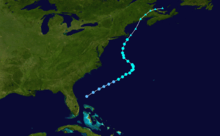
Tropical Storm Carrie
| Tropical storm (SSHWS) |
|
|
| Duration |
August 29 – September 3 |
| Peak intensity |
70 mph (110 km/h) (1-min) 993 mbar (hPa) |
A complex system combining a tropical wave and an upper level low led to the formation of a tropical depression east of Florida on August 29. It managed to become a tropical storm on August 31 and reached initial peak winds of 60 mph (95 km/h) later that day. However, upper-level winds increased, causing Carrie to weaken to a minimal tropical storm by September 2. Due to baroclinic processes, Carrie began to re-intensify. As a result, Carrie attained its peak winds of 70 mph (110 km/h) just prior to transitioning into an extratropical cyclone on September 3. The extratropical cyclone continued northeastward, and struck eastern Maine on September 4.[1] By the following day, the extratropical cyclone dissipated over the Gulf of Saint Lawrence.[3]
As Carrie passed Cape Cod, heavy rainfall occurred in that portion of Massachusetts, peaking at 12.50 in (318 mm) in Tashmoo. In addition, Carrie produced tropical storm and hurricane force winds in Massachusetts, Maine, and Rhode Island. In the wake of Carrie, $1.78 million (1972 USD; $10 million 2015 USD) in damage and four fatalities were reported throughout New England.[1]
Hurricane Dawn
| Category 1 hurricane (SSHWS) |
|
|
| Duration |
September 5 – September 14 |
| Peak intensity |
80 mph (130 km/h) (1-min) 997 mbar (hPa) |
A tropical wave, combined with an upper trophospheric trough, caused an area of convection to become a tropical depression on September 5, near the southeast coast of Florida. Though conditions were unfavorable, the depression managed to become Tropical Storm Dawn on September 6 and a hurricane on September 7. The development of a cold-core low near Cape Hatteras forced Dawn westward, then southeastward, where Dawn became a 50 mph (80 km/h) tropical storm. It continued to weaken as it approached the Georgia and South Carolina coasts, and it finally dissipated on September 14, causing little damage over land.
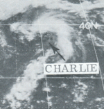
Subtropical Storm Charlie
| Subtropical storm (SSHWS) |
|
|
| Duration |
September 19 – September 21 |
| Peak intensity |
65 mph (100 km/h) (1-min) 996 mbar (hPa) |
Subtropical Storm Charlie formed on September 19 over the North Atlantic. It moved quickly northeastward, reaching 65 mph (105 km/h) winds before becoming extratropical on September 21. As an extratropical system, it became incredibly powerful, reaching a central pressure of 944 millibars (27.9 inHg), a reading typical of a strong Category 3 hurricane.
Subtropical Storm Delta
| Subtropical storm (SSHWS) |
|
|
| Duration |
November 1 – November 7 |
| Peak intensity |
45 mph (75 km/h) (1-min) 1001 mbar (hPa) |
Subtropical Storm Delta developed from a cold-core low. The low moved southwestward in late October, and on November 1 it developed into a subtropical depression. On November 2, it became Subtropical Storm Delta. It moved southwestward initially, then eastward on November 4, where it met unfavorable conditions. Delta became a depression again on November 5, and ultimately dissipated on November 7.
Other storms
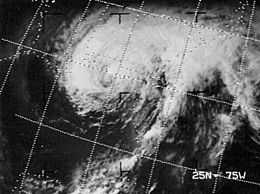
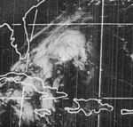
Tropical depression east of Hurricane Agnes on June 19, 1972 at 1619 UTC
In addition to the named storms and otherwise notable cyclones, there were several weak depressions during the season. As Agnes was moving over the southeastern United States, Tropical Depression Three formed approximately 400 mi (640 km) southwest of Bermuda.
Storm names
The following names were used for named storms (tropical storms and hurricanes) that formed in the North Atlantic in 1972.[4] Names that were not assigned are marked in gray. Storms were named Agnes, Betty and Dawn for the first time in 1972. The name Agnes was later retired.
- Agnes
- Betty
- Carrie
- Dawn
- Edna (unused)
- Felice (unused)
- Gerda (unused)
|
- Harriet (unused)
- Ilene (unused)
- Jane (unused)
- Kara (unused)
- Lucile (unused)
- Mae (unused)
- Nadine (unused)
|
- Odette (unused)
- Polly (unused)
- Rita (unused)
- Sarah (unused)
- Tina (unused)
- Velma (unused)
- Wendy (unused)
|
Subtropical storm names
The following names were used for subtropical storms (sometimes called neutercanes) in the Atlantic basin for this year. This year was the first year to use the Phonetic Alphabet for these storms. Names that were not assigned are marked in gray.
- Alpha
- Bravo
- Charlie
- Delta
- Echo (unused)
- Foxtrot (unused)
- Golf (unused)
|
- Hotel (unused)
- India (unused)
- Juliet (unused)
- Kilo (unused)
- Lima (unused)
- Mike (unused)
- November (unused)
|
- Oscar (unused)
- Papa (unused)
- Quebec (unused)
- Romeo (unused)
- Sierra (unused)
- Tango (unused)
- Uniform (unused)
|
- Victor (unused)
- Whiskey (unused)
- X-Ray (unused)
- Yankee (unused)
- Zulu (unused)
|
See also
References
- ↑ 1.0 1.1 1.2 1.3 1.4 1.5 R. H. Simpson and Paul J. Herbert (April 1973). "Atlantic Hurricane Season of 1972" (PDF). National Hurricane Center. Archived (PDF) from the original on 25 May 2011. Retrieved May 7, 2011.
- ↑ "Marine/Aviation Bulletin Number 1 Neutercane Bravo". National Hurricane Center. August 24, 1972. Retrieved July 8, 2012.
- ↑ National Hurricane Center; Hurricane Research Division (March 2, 2015). "Atlantic hurricane best track (HURDAT version 2)". United States National Oceanic and Atmospheric Administration. Retrieved April 20, 2015.
- ↑ Associated Press (1972-04-20). "If s Agnes, Betty, Carrie – no 'him-i-canes' again". Retrieved 2007-12-01.
External links
|
|---|
| | | |
-
 Book Book
-
 Category Category
-
 Portal Portal
-
 WikiProject WikiProject
-
 Commons Commons
|
|

.JPG)


