1970 Ancash earthquake
 | |
 Yungay Lima | |
| Date | May 31, 1970 |
|---|---|
| Origin time | 15:23:29 local [1] |
| Duration | ~ 45 seconds [2][3] |
| Magnitude | 7.9 Mw [1][4] |
| Depth | 45 km (28 mi) [1] |
| Epicenter | 9°24′S 78°54′W / 9.4°S 78.9°WCoordinates: 9°24′S 78°54′W / 9.4°S 78.9°W [4] |
| Areas affected | Peru |
| Max. intensity | VIII (Severe) [2] |
| Peak acceleration | .1g at Lima [3] |
| Tsunami | .38 m (1 ft 3 in) [5] |
| Casualties |
66,794 – 70,000 dead [5] 50,000 injured [5] |
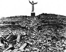
The 1970 Ancash earthquake (also known as the Great Peruvian earthquake) occurred on May 31 off the coast of Peru in the Pacific Ocean at 15:23:29 local time. Combined with a resultant landslide, it was the worst catastrophic natural disaster ever recorded in the history of Peru. Due to the large amounts of snow and ice included in the landslide and its estimated 66,794 to 70,000 casualties, it is also considered to be the world's deadliest avalanche.
Earthquake
The undersea earthquake struck on a Sunday afternoon and lasted about 45 seconds. The shock affected the Peruvian regions of Ancash and La Libertad. The epicenter was located 35 km (22 mi) off the coast of Casma and Chimbote on the Pacific Ocean, where the Nazca Plate is being subducted by the South American Plate. It had a moment magnitude of 7.9 and a maximum Mercalli Intensity of VIII (Severe).
Landslide
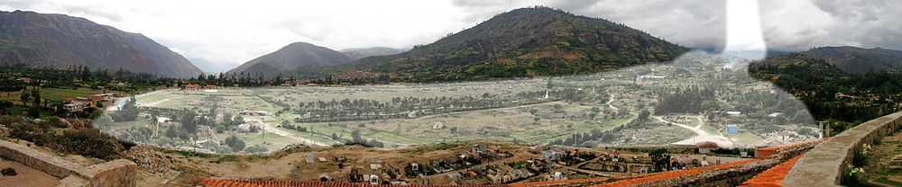
The northern wall of Mount Huascarán was destabilized, causing a rock, ice and snow avalanche and burying the towns of Yungay and Ranrahirca. The avalanche started as a sliding mass of glacial ice and rock about 3,000 feet (910 m) wide and one mile (1.6 km) long. It advanced about 11 miles (18 km) to the village of Yungay at an average speed of 280 to 335 km per hour.[6] The fast-moving mass picked up glacial deposits and by the time it reached Yungay, it is estimated to have consisted of about 80 million cubic meters (80,000,000 m³) of water, mud, and rocks.
See also
References
- ↑ 1.0 1.1 1.2 ISC (2014), ISC-GEM Global Instrumental Earthquake Catalogue (1900-2009), Version 1.05, International Seismological Centre
- ↑ 2.0 2.1 Plafker, Ericksen & Fernández Concha 1971, p. 545
- ↑ 3.0 3.1 Cluff, L.S. (1971), "Peru earthquake of May 31, 1970; Engineering geology observations" (PDF), Bulletin of the Seismological Society of America (Seismological Society of America) 61 (3): 514
- ↑ 4.0 4.1 Utsu, T. R. (2002), "A List of Deadly Earthquakes in the World: 1500-2000", International Handbook of Earthquake & Engineering Seismology, Part A, Volume 81A (First ed.), Academic Press, p. 708, ISBN 978-0124406520
- ↑ 5.0 5.1 5.2 USGS (September 4, 2009), PAGER-CAT Earthquake Catalog, Version 2008_06.1, United States Geological Survey
- ↑ Plafker, Ericksen & Fernández Concha 1971, p. 543
- Sources
- Plafker, G.; Ericksen, G.E.; Fernández Concha, J. (1971), "Geological aspects of the May 31, 1970, Perú earthquake" (PDF), Bulletin of the Seismological Society of America (Seismological Society of America) 61 (3): 543–578
External links
- IRIS SeismoArchive for 1970 Peru earthquake – IRIS Consortium
- Yungay 1970-2009: remembering the tragedy of The Earthquake – Peruvian Times
| ||||||||||