1963 Atlantic hurricane season
 | |
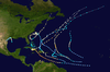
| Season summary map | |
| First system formed | July 31, 1963 |
|---|---|
| Last system dissipated | October 29, 1963 |
| Strongest storm | Flora – 940 mbar (hPa) (27.77 inHg), 145 mph (230 km/h) (1-minute sustained) |
| Total depressions | 9 |
| Total storms | 9 |
| Hurricanes | 7 |
| Major hurricanes (Cat. 3+) | 2 |
| Total fatalities | 7,225 |
| Total damage | $830.1 million (1963 USD) |
| Atlantic hurricane seasons 1961, 1962, 1963, 1964, 1965 | |
The 1963 Atlantic hurricane season featured one of the deadliest tropical cyclones on record in the Atlantic basin – Hurricane Flora. The season officially began on June 15, and lasted until November 15. These dates conventionally delimit the period of each year when most tropical cyclones form in the Atlantic basin. It was a below average season in terms of tropical storms, with a total of nine named storms. The first system, Hurricane Arlene, developed between Cape Verde and the Lesser Antilles on July 31. In Bermuda, strong winds resulted in about $300,000 (1963 USD) in damage. Hurricanes Beulah and Debra, as well as an unnamed tropical storm, did not impact land. During the month of September, Hurricane Cindy caused wind damage and flooding in Texas. Overall, the storm resulted in three deaths and approximately $12.5 million in damage. Hurricane Edith passed through the Lesser Antilles and the eastern Greater Antilles, causing 10 deaths and about $43 million in damage, most of which occurred on Martinique.
The most significant storm of the season was Hurricane Flora, which peaked as a Category 4 hurricane on the Saffir–Simpson hurricane wind scale. Drifting slowly and executing a cyclonic loop, Flora dropped very heavy rainfall in the Greater Antilles, including over 100 in (2,500 mm) in Cuba. Extreme flooding ensued, leaving behind at least 7,193 fatalities and about $773.4 million in damage. Flora is thus listed among the deadliest Atlantic hurricanes on record. In October, Hurricane Ginny moved erratically offshore the Southeastern United States, though eventually, the extratropical remnants struck Nova Scotia. Ginny caused at least three deaths and $400,000 in damage in the United States alone. The final cyclone, Tropical Storm Helena, caused five deaths and over $500,000 in damage on Guadeloupe. Overall, the storms in this season caused at least 7,225 deaths and about $830.1 million in damage.
Season summary
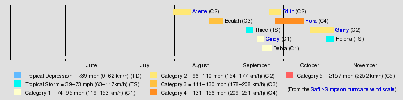
The Atlantic hurricane season officially began on June 15, 1963, and ended on November 15, 1963.[1] It was below average with nine tropical storms,[2] slightly less than the 1950–2000 average of 9.6 named storms.[3] Seven of these reached hurricane status,[2] which is above the 1950–2000 average of 5.9.[3] Furthermore, two storms reached major hurricane status,[2] which is Category 3 or higher on the Saffir–Simpson hurricane wind scale.[4] A total of four hurricanes made landfall during the season,[2] causing at least 7,225 deaths and $830.1 million in damage.[5] Hurricane Ginny and Tropical Storm Helena also caused damage and deaths, despite remaining offshore and then after becoming extratropical.
Tropical cyclogenesis began late, with Hurricane Arlene developing on July 31. Another system formed in August, Hurricane Beulah. September was much more active, with an unnamed tropical storm, as well as hurricanes Cindy, Debra, Edith, and Flora all developing in that month. Flora was the most intense tropical cyclone of the season, peaking as a Category 4 hurricane with winds of 145 mph (233 km/h) and a minimum barometric pressure of 940 mbar (28 inHg). There were two other system in October, Hurricane Ginny and Tropical Storm Helena; the latter dissipated on October 29.[2]
The season's activity was reflected with an accumulated cyclone energy (ACE) rating of 118, one of the highest values recorded.[4] ACE is, broadly speaking, a measure of the power of the hurricane multiplied by the length of time it existed, so storms that last a long time, as well as particularly strong hurricanes, have high ACEs. It is only calculated for full advisories on tropical systems at or exceeding 39 mph (63 km/h), which is tropical storm strength. Subtropical cyclones are excluded from the total.[6]
Storms
Hurricane Arlene
| Category 2 hurricane (SSHWS) | |||
|---|---|---|---|
| |||
| Duration | July 31 – August 10 | ||
| Peak intensity | 105 mph (165 km/h) (1-min) 969 mbar (hPa) | ||

A cloud mass in the central Atlantic became a tropical depression on July 31. It headed to the west, becoming a tropical storm on August 2. Arlene rapidly intensified that day to become a 100 mph (160 km/h) Category 2 hurricane, but lack of outflow weakened Arlene to a tropical depression on August 4. For the next three days, a disturbed area of low pressure that may have had a circulation moved to the northwest. On August 8, while turning northeastward, conditions favored development again, and Arlene rapidly intensified to a hurricane that night. Arlene passed over Bermuda on August 9, and, after reaching its peak of 100 mph (160 km/h) again that night, steadily weakened until it became extratropical on August 11. Arlene caused $300,000 (1963 USD, $2.31 million 2015 USD) in property damage in Bermuda, but no lives were lost.
Hurricane Beulah
| Category 3 hurricane (SSHWS) | |||
|---|---|---|---|
| |||
| Duration | August 20 – August 28 | ||
| Peak intensity | 120 mph (195 km/h) (1-min) 958 mbar (hPa) | ||


The precursor to Hurricane Beulah was a tropical wave moving across the tropical Atlantic. It was organized enough to be called a tropical depression on August 20, and it strengthened to tropical storm force the next day. Beulah moved northwestward, becoming a hurricane on August 22 and a major hurricane on August 24. The hurricane turned to the north, where the anticyclone that was favoring development to its south caused unfavorable conditions. Beulah weakened to a minimal hurricane, and raced to the northeast, maintaining hurricane strength until it became extratropical on August 28, 250 mi (400 km) east of Newfoundland.
Tropical Storm Three
| Tropical storm (SSHWS) | |||
|---|---|---|---|
| |||
| Duration | September 10 – September 14 | ||
| Peak intensity | 60 mph (95 km/h) (1-min) 992 mbar (hPa) | ||
As early as September 8, ships north of Puerto Rico reported a weak circulation.[5] A tropical depression developed at 06:00 UTC on September 10, while situated about 150 mi (240 km) southwest of Bermuda.[2] The cyclone was subtropical in nature, developing with the instability of cool and warm air. While passing Bermuda later on September 10, sustained wind speeds of 25 mph (40 km/h) and decrease in barometric pressure were observed.[5] The system moved east-northeastward and strengthening into a tropical storm early the following day. By late on September 12, the storm attained its peak intensity with maximum sustained winds of 60 mph (97 km/h) and a minimum barometric pressure of 992 mbar (29.3 inHg). Thereafter, the system accelerated ahead of a cold front and became extratropical on September 14, while located about 725 mi (1,167 km) north-northwest of Corvo Island in the Azores. The extratropical remnants moved rapidly eastward, until dissipating well west of Ireland early on September 15.[2]
Hurricane Cindy
| Category 1 hurricane (SSHWS) | |||
|---|---|---|---|
| |||
| Duration | September 16 – September 20 | ||
| Peak intensity | 80 mph (130 km/h) (1-min) 996 mbar (hPa) | ||


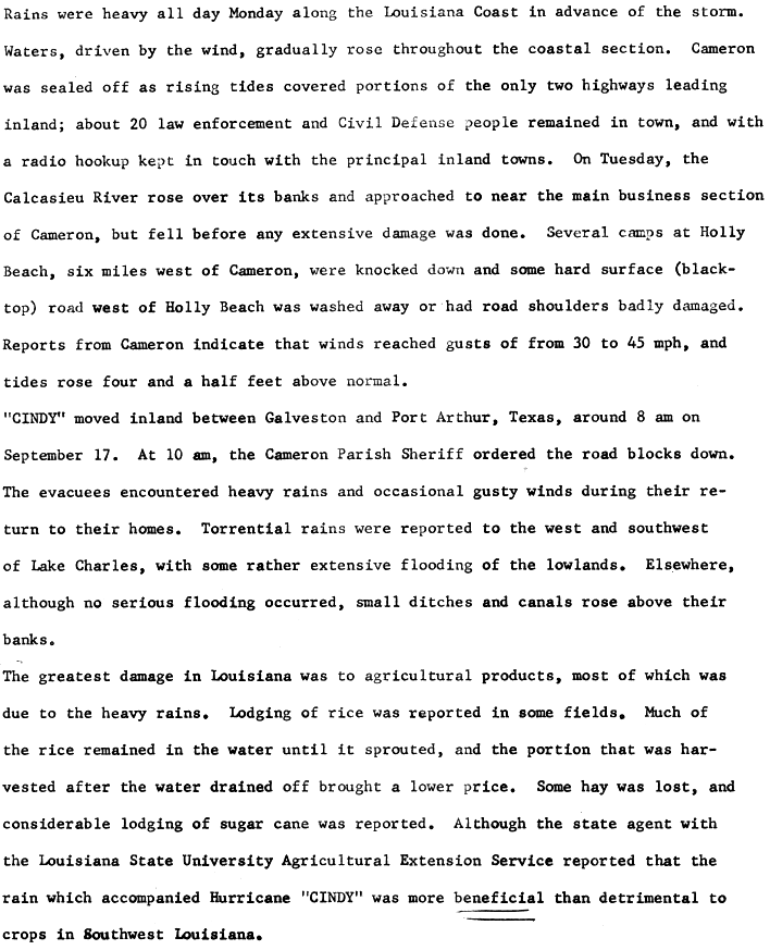
In mid-September, a trough of low pressure was situated in the Gulf of Mexico.[5] The system developed into Tropical Storm Cindy at 12:00 UTC on September 16, while located about 210 mi (340 km) south of Cameron, Louisiana. Cindy strengthened quickly and reached hurricane intensity early on September 17. Around that time, the storm attained its peak intensity with maximum sustained winds of 80 mph (130 km/h) and a minimum barometric pressure of 996 mbar (29.4 inHg). Shortly after 12:00 UTC on September 17, Cindy made landfall near High Island, Texas with winds of 75 mph (121 km/h). Early the following day, the hurricane weakened to a tropical storm and further to a tropical depression about six hours later. Moving southwestward, the depression dissipated at 00:00 UTC on September 20.[2]
In southwestern Louisiana, over 15 in (380 mm) of rain fell in some areas. Rice crops were flooded, causing about $360,000 in damage. However, the precipitation was described as more "beneficial" than detrimental.[5] Along the coast, tides inundated roads leading to Cameron and Holly Beach.[7] A man drowned offshore Cameron while attempting to evacuate personnel from the oil rigs. The storm brought flooding to the southeastern Texas, particularly the Port Arthur area. Two twin sister drowned in Port Acres. Collectively, water entered 4,000 homes in Jefferson, Newton, and Orange counties. Property damage reached approximately $11.7 million.[5] In Oklahoma, flooding occurred in Guthrie, causing 300 residents to flee their homes. Water intruded into 25 businesses and 35 homes.[8] Overall, Cindy caused about $12.5 million in damage.[5]
Hurricane Debra
| Category 1 hurricane (SSHWS) | |||
|---|---|---|---|
| |||
| Duration | September 19 – September 24 | ||
| Peak intensity | 75 mph (120 km/h) (1-min) 999 mbar (hPa) | ||

On September 19, a westward moving tropical wave became a tropical depression in the central tropical Atlantic. It became a tropical storm on September 21, and spared the islands as it turned northward. Debra became a hurricane on September 21, but as it moved northward, it was gradually absorbed by a large extratropical storm. Debra dissipated on September 24.
Hurricane Edith
| Category 2 hurricane (SSHWS) | |||
|---|---|---|---|
| |||
| Duration | September 23 – September 29 | ||
| Peak intensity | 100 mph (155 km/h) (1-min) 990 mbar (hPa) | ||


The Intertropical Convergence Zone developed a tropical depression on September 23, east of the southern Lesser Antilles. It moved west-northwestward, quickly intensifying to a hurricane on September 24. It crossed through the Windward Islands on September 25 as a 95 mph (153 km/h) hurricane, but upper level winds weakened it to a minimal hurricane prior to its Dominican Republic landfall on September 27. The island ripped apart the circulation, and Edith dissipated on September 29. Edith killed ten in Martinique, injured 50 across the Caribbean, and caused $47 million (1963 USD, $362 million 2015 USD) in damage. It was a prelude to Hurricane Flora just days later.
Hurricane Flora
| Category 4 hurricane (SSHWS) | |||
|---|---|---|---|
| |||
| Duration | September 26 – October 12 | ||
| Peak intensity | 145 mph (230 km/h) (1-min) 940 mbar (hPa) | ||

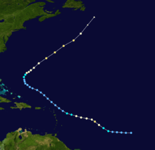
Hurricane Flora originated from a tropical depression which formed on September 26 in the Central Atlantic. The depression moved rapidly west-northwestward, and on September 29 it reached tropical storm status. It then rapidly intensified into a 120 mph (190 km/h) Category 3 hurricane by September 30. Flora moved through the Leeward Islands, first striking the island of Tobago, and passing near Grenada shortly afterwards. Flora then crossed the Caribbean Sea and strengthened to a Category 4 hurricane, peaking at 140 mph (230 km/h) winds.
Flora struck the southwest peninsula of Haiti on October 4 as a 140 mph (230 km/h) hurricane, causing heavy rains. Flora then hit southeast Cuba near Guantanamo Bay on the same day, but a high pressure system to its north and west caused it to drift over Cuba and nearby waters. During this time, intense driving rains caused catastrophic flooding, resulting in thousands of deaths and millions in crop damage. A shortwave trough finally pulled Flora to the northeast, bringing the hurricane into the Atlantic Ocean on October 8. Flora strengthened over the open Atlantic, but posed a threat only to shipping, and became extratropical on October 12.
Hurricane Flora was the fifth or sixth deadliest Atlantic hurricane of all time, causing over 7,000 deaths and hundreds of millions of dollars in damage, mostly due to flooding from intense rains as it stalled over Cuba and the surrounding areas. Damage estimates (mostly crop losses) reached over $500 million (1963 USD, $3.85 billion 2015 USD).
Hurricane Ginny
| Category 2 hurricane (SSHWS) | |||
|---|---|---|---|
| |||
| Duration | October 16 – October 29 | ||
| Peak intensity | 110 mph (175 km/h) (1-min) 948 mbar (hPa) | ||


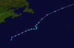
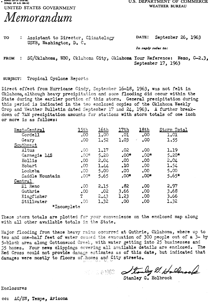
On October 16, a tropical depression formed near Turks and Caicos from the interaction of a trough and a tropical wave, although the system was not very tropical due to cold air.[5][9] It moved to the north and northwest, becoming Tropical Storm Ginny on October 19. The next day it attained hurricane status,[2] and approached North Carolina before looping to the southwest due to a ridge over New England. By October 22, Ginny crossed the Gulf Stream and intensified, developing an eye. It briefly weakened to a tropical storm the next day while approaching Florida, but regained hurricane intensity within ten hours.[5][9] Ahead of an advancing trough,[10] Ginny turned sharply northward and later northeastward, paralleling the coast of the Southeastern United States. For eight days, the storm was within 250 mi (400 km) of the United States coastline. Moving farther offshore, Ginny gradually intensified to reach peak winds of 110 mph (180 km/h) on October 29.[5][9] Later that day it became extratropical before striking southwestern Nova Scotia, while the remnants dissipated on October 30 in the Gulf of Saint Lawrence.[2]
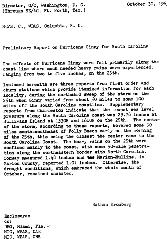
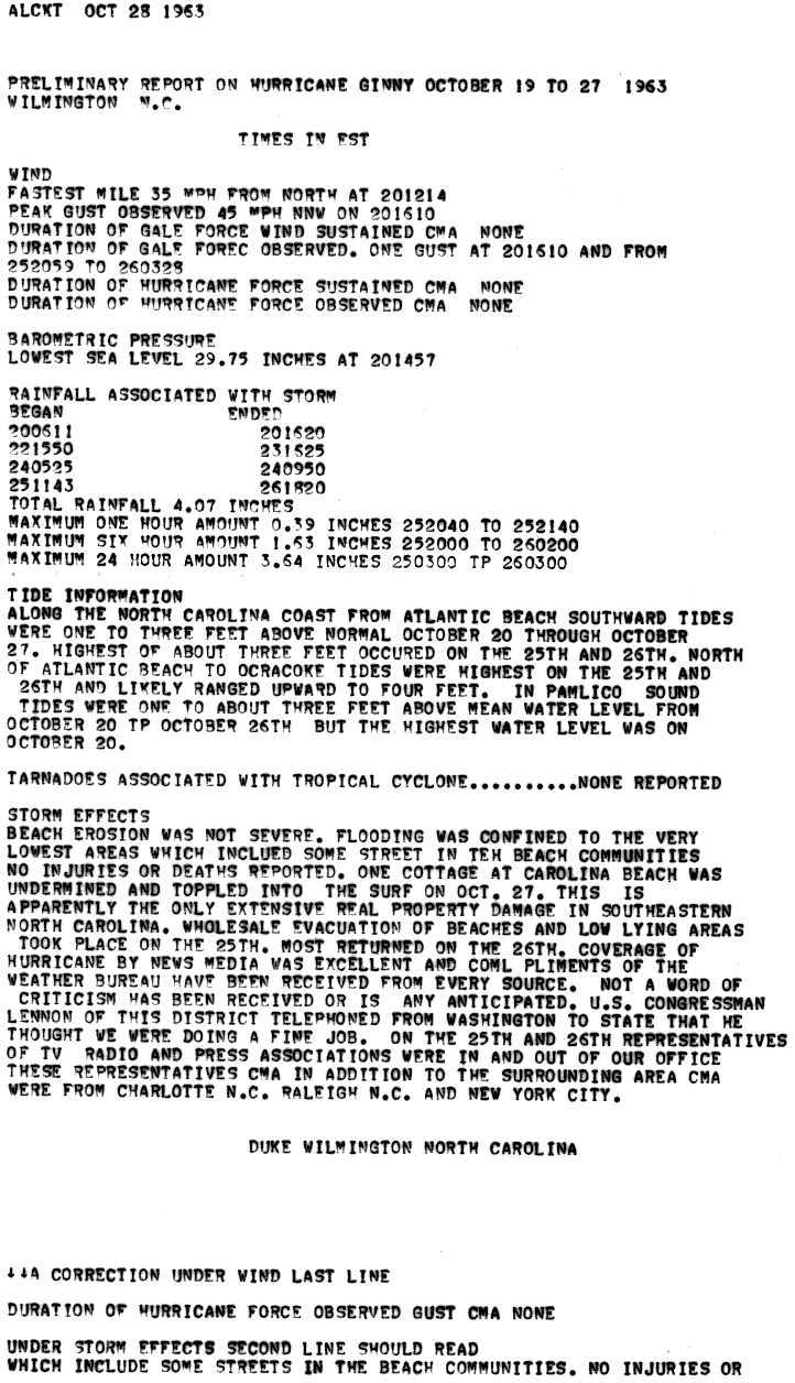
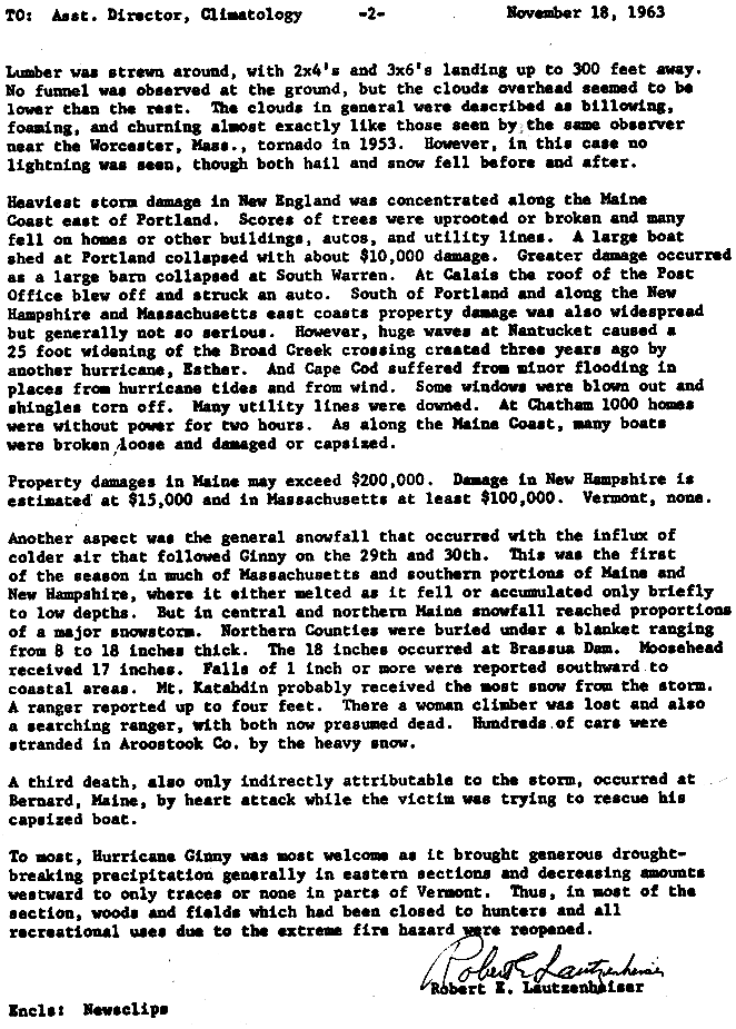
Early in its track, Ginny dropped heavy rainfall in the Dominican Republic and the Bahamas.[11] In Florida and Georgia, Ginny produced above normal tides that caused minor damage and beach erosion.[5] Rainfall was beneficial in South Carolina,[12] and in North Carolina, high tides caused minor flooding and destroyed one house.[13] Wind gusts reached 76 mph (122 km/h) in Nantucket,[5] causing power outages that left about 1,000 homes in Chatham, Massachusetts without power. Many boats were damaged or ripped from their moorings in Maine, and one person died from a heart attack while trying to rescue his boat.[14] Ginny was the latest hurricane on record to affect Maine,[15] and during its passage, the storm brought an influx of cold air that produced up to 4 ft (1.2 m) of snow in northern Maine, killing two people.[14] Damage from Ginny in the United States was estimated at $400,000.[5] In Canada, high winds downed trees and caused power outages, leaving the entirety of Prince Edward Island without power.[16]
Tropical Storm Helena
| Tropical storm (SSHWS) | |||
|---|---|---|---|
| |||
| Duration | October 25 – October 29 | ||
| Peak intensity | 50 mph (85 km/h) (1-min) ≤ 1001 mbar (hPa) | ||

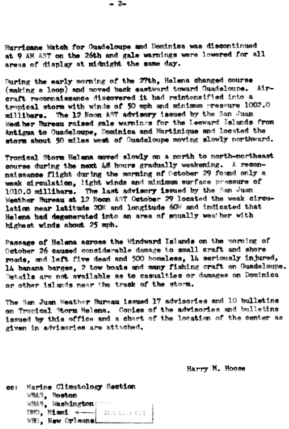
A tropical wave accompanied by a large area of convection moved westward in late October. On October 25, the wave spawned a tropical depression, based on ship and Hurricane Hunter reports of southwest winds and heavy rainfall. Although it was not well-defined, the system intensified gradually and became Tropical Storm Helena.[5] On October 26, the storm reached peak winds of 50 mph (80 km/h),[2] before quickly weakening when it passed between Dominica and Guadeloupe, potentially due to their high terrain.[5] Helena was a weak tropical depression upon entering the eastern Caribbean Sea, but it re-intensified into a tropical storm after turning to the north on October 27.[2] Its slow, erratic movement and failure to intensify was due to a weak trough across the region. While passing near Antigua, the storm developed an intense rainband that produced winds of 58 mph (93 km/h), as measured by aircraft between Dominica and Guadeloupe. However, Helena again weakened into a tropical depression on October 29 and dissipated shortly thereafter.[5]
The threat of Helena prompted the San Juan Weather Bureau to issue a hurricane watch and later gale warnings for portions of the Lesser Antilles.[17] While passing through the Lesser Antilles, Helena heavily damaged or sank several boats on Guadeloupe. On the island, the storm left 500 people homeless, killed five people, and seriously injured fourteen others. Damage was estimated at $500,000.[5]
Storm names
The following names were used for named storms (tropical storms and hurricanes) that formed in the North Atlantic in 1963. Storms were named Ginny and Helena for the first time in 1963. Names that were not assigned are marked in gray.
|
|
Retirement
The name Flora was later retired.
See also
- 1963 Pacific hurricane season
- 1963 Pacific typhoon season
- 1963 North Indian Ocean cyclone season
- List of Atlantic hurricanes
- List of Atlantic hurricane seasons
References
- ↑ "21 Stormy Ladies". The Age (Washington, D.C.). Associated Press and Reuters. June 6, 1963. p. 3. Retrieved June 27, 2014.
- ↑ 2.0 2.1 2.2 2.3 2.4 2.5 2.6 2.7 2.8 2.9 2.10 2.11 National Hurricane Center; Hurricane Research Division (March 2, 2015). "Atlantic hurricane best track (HURDAT version 2)". United States National Oceanic and Atmospheric Administration. Retrieved April 20, 2015.
- ↑ 3.0 3.1 Philip J. Klotzbach and William M. Gray (December 8, 2006). Extended Range Forecast of Atlantic Seasonal Hurricane Activity and U.S. Landfall Strike Probability for 2007 (Report). Boulder, Colorado: Colorado State University. Archived from the original on 18 December 2006. Retrieved March 28, 2014.
- ↑ 4.0 4.1 Atlantic basin Comparison of Original and Revised HURDAT. Hurricane Research Division; Atlantic Oceanographic and Meteorological Laboratory (Report) (National Oceanic and Atmospheric Administration). March 2011. Retrieved March 6, 2012.
- ↑ 5.0 5.1 5.2 5.3 5.4 5.5 5.6 5.7 5.8 5.9 5.10 5.11 5.12 5.13 5.14 5.15 5.16 Gordon E. Dunn (March 1964). "The Hurricane Season of 1963" (PDF). Monthly Weather Review (Miami, Florida: United States Weather Bureau) 92 (3). Retrieved June 29, 2014.
- ↑ David Levinson (August 20, 2008). 2005 Atlantic Ocean Tropical Cyclones. National Climatic Data Center (Report) (National Oceanic and Atmospheric Administration). Archived from the original on December 1, 2005. Retrieved March 6, 2012.
- ↑ E. J. Saltsman (October 16, 1963). Final report – Hurricane "Cindy", September 16–20, 1963. Weather Bureau Office, New Orleans, Louisiana (Report) (New Orleans, Louisiana: National Oceanic and Atmospheric Administration; National Hurricane Center): 3. Retrieved July 2, 2014.
- ↑ Stanley G. Holbrok (September 26, 1963). Tropical Cyclone Reports. Weather Bureau Office, Oklahoma City, Oklahoma (Report) (Oklahoma City, Oklahoma: National Oceanic and Atmospheric Administration; National Hurricane Center). Retrieved July 2, 2014.
- ↑ 9.0 9.1 9.2 Lewis J. Allison; Harold P. Thompson (June 1966). "TIROS VII Infrared Radiation Coverage of the 1963 Atlantic Hurricane Season With Supporting Television and Conventional Meteorological Data" (PDF). NASA. Retrieved 2011-10-16.
- ↑ P.L. Moore (1963-10-28). Ginny Advisory Number 31 (GIF) (Report). National Hurricane Center. Retrieved 2011-10-16.
- ↑ Roth, David M; Hydrometeorological Prediction Center (November 16, 2012). "Tropical Cyclone Rainfall Point Maxima". Tropical Cyclone Point Maxima. United States National Oceanic and Atmospheric Administration's National Weather Service. Retrieved December 7, 2012.
- ↑ Nathan Kronberg, Columbia, S.C. Weather Bureau Air Station (1963-10-30). "Preliminary Report on Hurricane Ginny in South Carolina" (GIF). National Hurricane Center. Retrieved 2011-10-16.
- ↑ Wilmington, N.C. Weather Bureau Office (1963-10-28). "Preliminary Report on Hurricane Ginny October 19 to 27 1963". National Hurricane Center. Retrieved 2011-10-17.
- ↑ 14.0 14.1 Robert E. Lautzenhaiser, Boston Massachusetts Weather Bureau State Climatologist (1963-11-18). "Tropical Cyclone Reports — Hurricane Ginny" (GIF). National Hurricane Center. Retrieved 2011-10-17.
- ↑ Wayne Cotterly (1996). "Hurricanes and Tropical Storms; Their Impact on Maine and Androscoggin County" (PDF). Retrieved 2011-10-17.
- ↑ Canadian Hurricane Centre (2010-09-14). "1963-Ginny". Retrieved 2011-10-17.
- ↑ Harry M. Hoose (1963-11-01). Tropical Storm Helena, October 25-29, 1963 (GIF) (Report). San Juan Weather Bureau. Retrieved 2013-04-24.
External links
| |||||||||||||