1958 Lituya Bay megatsunami
 Anchorage | |
| Date | July 10, 1958 UTC |
|---|---|
| Origin time | 06:15:58 a.m. UTC [1] |
| Magnitude | 7.8 Mw [1][2][3] |
| Depth | 35 km (22 mi) [2] |
| Epicenter | 58°22′12″N 136°39′54″W / 58.370°N 136.665°WCoordinates: 58°22′12″N 136°39′54″W / 58.370°N 136.665°W [2] |
| Type | Strike-slip [4] |
| Areas affected | Lituya Bay, Alaska |
| Max. intensity | XI (Extreme) [2] |
| Tsunami | 525 m (1,722 ft) [3] |
| Casualties | 5 [5] |
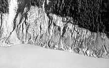
The 1958 Lituya Bay megatsunami occurred on July 9 at 10:15:58 p.m. with a moment magnitude of 7.8 and a maximum Mercalli Intensity of XI (Extreme). The event took place on the Fairweather Fault and triggered a landslide that caused 30 million cubic metres of rock and ice to fall into the narrow inlet of Lituya Bay, Alaska.[6] The sudden displacement of water resulted in a megatsunami that destroyed vegetation up to 525 m (1,722 ft) above the height of the bay and a wave that traveled across the bay with a crest reported by witnesses to be on the order of 30 m (100 ft) in height.[6] This is the most significant megatsunami and the largest known in modern times. The event forced a re-evaluation of large wave events, and recognition of impact and landslide events as a previously unknown cause of very large waves.
Lituya Bay
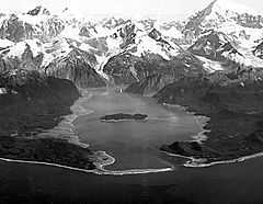
Lituya Bay is a fjord located on the Fairweather Fault in the northeastern part of the Gulf of Alaska.[6] It is a T-shaped bay with a width of two miles (3 km) and a length of seven miles.[7] Lituya Bay is an ice-scoured tidal inlet with a maximum depth of 220 m (722 ft). The narrow entrance of the bay has a depth of only 10 m (33 ft).[7] The two arms that create the top of the T-shape of the bay are the Gilbert and Crillon inlets and are a part of a trench on the Fairweather Fault.[8] In the past 150 years Lituya Bay has had three other tsunamis of over 100 ft: 1854 (395 feet), 1899 (200 feet) and 1936 (490 feet).[9][10]
Near the crest of the Fairweather Mountains sit the Lituya and the North Crillon glaciers. They are each about 12 miles (19 km) long and one mile (1.6 km) wide with an elevation of 4000 ft (1,220 m). The retreats of these glaciers form the present T shape of the bay, the Gilbert and Crillon inlets.[8]
Earthquake
The major earthquake that struck on the Fairweather Fault had a moment magnitude of 7.8 and a maximum perceived intensity of XI (Extreme) on the Mercalli intensity scale. The epicentre of the quake was at latitude 58.37° N, longitude 136.67° W near the Fairweather Range, 7.5 miles (12.1 km) east of the surface trace of the Fairweather fault, and 13 miles (21 km) southeast of Lituya Bay. This earthquake had been the strongest in over 50 years for this region: the Cape Yakataga earthquake, with a reading of 8.2 on the Richter scale, occurred on September 4, 1899.[5] The shock was felt in southeastern Alaskan cities over an area of 400,000 square miles (1,000,000 km2), as far south as Seattle, Washington, and as far east as Whitehorse, Yukon, Canada.[8]
Landslide
The earthquake caused a subaerial rock fall in the Gilbert Inlet.[8] This landslide caused over 30 million cubic meters of rock to fall into the bay, creating the megatsunami.[7] Deaths from the event totaled five, with three being killed on Khantaak Island and two having been caught by a wave in the bay.[5] In Yakutat, the only permanent outpost close to the epicenter at the time, infrastructure such as bridges, docks, and oil lines all sustained damage. A water tower collapsed and a cabin was also damaged beyond repair. Sand boils and fissures occurred near the coast southeast of there, and underwater cables that supported the Alaska Communication System were cut.[5] Lighter damage was also reported in Pelican and Sitka.
After the earthquake there was an observation made on the subglacial lake, located northwest of the bend in the Lituya Glacier at the head of Lituya Bay. This subglacial lake had dropped 100 ft (30 m). So this proposed another possible cause to the production of the 100 foot (30 meter) wave which caused destruction as high as 1,720ft (524 m) above the surface of the bay as its momentum carried it upslope. It is possible that a good amount of water drained from the glacial lake through a glacial tunnel flowing directly in front of the glacier, though neither the rate of drainage nor the volume of water drained could produce a wave of such magnitude.[8] Even if a large enough drainage were to take place in front of the Gilbert Glacier, the run-off would have been projected to be on the opposite side in Crillon inlet. After these considerations glacial drainage was not the mechanism that caused the giant wave.[8]
Eyewitness account
At 22:15 hours PST on July 9, 1958, which was still daylight at that time of year, an earthquake with a magnitude of 7.9 struck the Lituya Bay area. The tide was ebbing at about plus 1.5 m and the weather was clear. Anchored in Anchorage Cove, near the west side of the entrance of the bay,:[7]
With the first jolt, I tumbled out of the bunk and looked toward the head of the bay where all the noise was coming from. The mountains were shaking something awful, with slide of rock and snow, but what I noticed mostly was the glacier, the north glacier, the one they call Lituya Glacier. I know you can’t ordinarily see that glacier from where I was anchored. People shake their heads when I tell them I saw it that night. I can’t help it if they don’t believe me. I know the glacier is hidden by the point when you’re in Anchorage Cove, but I know what I saw that night, too. The glacier had risen in the air and moved forward so it was in sight. It must have risen several hundred feet. I don’t mean it was just hanging in the air. It seems to be solid, but it was jumping and shaking like crazy. Big chunks of ice were falling off the face of it and down into the water. That was six miles away and they still looked like big chunks. They came off the glacier like a big load of rocks spilling out of a dump truck. That went on for a little while—its hard to tell just how long—and then suddenly the glacier dropped back out of sight and there was a big wall of water going over the point. The wave started for us right after that and I was too busy to tell what else was happening up there.[7]
The wave caused damage to the foliage up the headlands around the area where the landslide occurred up to a height of 1720 feet, as well as along the shoreline of the bay.[6]
See also
References
- ↑ 1.0 1.1 ISC (2014), ISC-GEM Global Instrumental Earthquake Catalogue (1900-2009), Version 1.05, International Seismological Centre
- ↑ 2.0 2.1 2.2 2.3 NGDC. "Comments for the Significant Earthquake". National Oceanic and Atmospheric Administration. Retrieved 7 September 2011.
- ↑ 3.0 3.1 USGS (September 4, 2009), PAGER-CAT Earthquake Catalog, Version 2008_06.1, United States Geological Survey
- ↑ Yeats, R. (2012), Active Faults of the World, Cambridge University Press, p. 32, ISBN 978-0521190855
- ↑ 5.0 5.1 5.2 5.3 Coffman, Jerry L; von Hake, Carl A, eds. (1970). Earthquake History of the United States. United States Department of Commerce/Department of the Interior. p. 108. Publication 41-1.
- ↑ 6.0 6.1 6.2 6.3 Leonard, L J; Rogers, G C; Hyndman, R D (2010). "Open File 6552". Geological Survey of Canada. Natural Resources Canada. p. 248.
- ↑ 7.0 7.1 7.2 7.3 7.4 Mader, C.L.; Gittings, M.L. (2002). "Modeling the 1958 Lituya Bay mega-tsunami, II" (PDF). The International Journal of The Tsunami Society (Tsunami Society) 20 (5): 241–245.
- ↑ 8.0 8.1 8.2 8.3 8.4 8.5 Pararas-Carayannis, George (1999). "The Mega-Tsunami of July 9, 1958 in Lituya Bay, Alaska". Retrieved 2012-02-11.
- ↑ Miller, Don J. "Giant Waves in Lituya Bay, Alaska". UWSP. Retrieved 2013-12-03.
- ↑ Casey, Susan (2010), The Wave, Doubleday, pp. 153–58.
- References
- Miller, D. J. (1960), "The Alaska earthquake of July 10, 1958: Giant wave in Lituya Bay", Bulletin of the Seismological Society of America (Seismological Society of America) 50 (2): 253–266
External links
| Wikimedia Commons has media related to Lituya Bay megatsunami. |
- Gary Griggs, Our Ocean Backyard: Tsunami rocked Alaska's Lituya Bay in 1958, Santa Cruz Sentinel, April 9, 2011
- Dave Kiffer, Surviving the Biggest Wave Ever 50 Years Ago, 1,700 Foot Wave Devastated Lituya Bay, SitNews, July 8, 2008.
- Howard Ulrich, What It Feels Like...to Survive a Tsunami, Esquire, August 1, 2004.
- Sonny and Howard Ulrich Video retelling of their surviving the event & simulated megatsunami
- Horizon, BBC, first broadcast 12 October 2000. (Mega-tsunami: Wave of Destruction)
| ||||||