1933 Sanriku earthquake
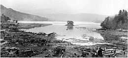 Kamaishi Bay, Iwate after 1933 earthquake and tsunami | |
 | |
| Date | Thursday, March 2, 1933 |
|---|---|
| Magnitude | 8.4 Mw |
| Epicenter | 39°7.7′N 144°7′E / 39.1283°N 144.117°ECoordinates: 39°7.7′N 144°7′E / 39.1283°N 144.117°E |
| Areas affected | Japan, United States |
| Tsunami | Yes |
| Casualties | 3000+ dead |

The 1933 Sanriku earthquake (昭和三陸地震 Shōwa Sanriku Jishin) occurred on the Sanriku coast of the Tōhoku region of Honshū, Japan on March 2. The associated tsunami caused widespread damage.
History
The epicenter of the 1933 Sanriku earthquake was located offshore, 290 kilometres (180 mi) east of the city of Kamaishi, Iwate. The initial shock occurred at 0231 AM local time on March 3, 1933 (1731 GMT March 2, 1933). The earthquake measured 8.4 on the moment magnitude scale [1] and was in approximately the same location as the 1896 Meiji-Sanriku earthquake. The epicenter occurred far enough away from the town that the earthquake itself did little damage to buildings. Approximately three hours after the main shock was a magnitude 6.8 aftershock, followed by 76 more aftershocks (with a magnitude of 5.0 or greater) over a period of six months.[2]
This earthquake was an intraplate earthquake in the Pacific Plate.[3] The focal mechanism of this earthquake showed that it was a normal faulting earthquake.[4]
Damage
Although the earthquake did little damage, the associated tsunami, which was recorded to reach the height of 28.7 metres (94 ft) at Ōfunato, Iwate, caused extensive damage, destroyed many homes and caused numerous casualties [5] The tsunami destroyed over 7,000 homes along the northern Japanese coastline, of which over 4,885 were washed away. The tsunami was also recorded in Hawaii with a height of 9.5 feet (2.9 m), and which also resulted in slight damage.[1] The death toll came to 1522 people confirmed dead, 1542 missing, and 12,053 injured. Hardest hit was the town of Tarō, Iwate (now part of Miyako city), with 98% of its houses destroyed and 42% of its population killed.[6]
See also
- Earthquakes in 1933
- Seismicity of the Sanriku coast
Notes
- ↑ 1.0 1.1 "Historical Earthquakes:The 1933 Sanriku earthquake". United States Geological Survey. 14 March 2008. Archived from the original on 24 July 2008. Retrieved 2008-07-16.
- ↑ title
- ↑ "日本海溝・千島海溝周辺海溝型地震に関する専門調査会報告" by 日本海溝・千島海溝周辺海溝型地震に関する専門調査会
- ↑ "Outer trench-slope faulting and the 2011 Mw 9.0 off the Pacific coast of Tohoku Earthquake" by T. Lay, C. J. Ammon, H. Kanamori, M. J. Kim, and L. Xue
- ↑ The Great Meiji Sanriku tsunami of 1896 is estimated to have generated a wave 38.2 meters high (Masayuki Nakao, "The Great Meiji Sanriku Tsunami"
- ↑ Corkill, Edan, "Heights of survival", Japan Times, 12 June 2011, pp. 9-10.
- Sources
- Clancey, Gregory. (2006). Earthquake Nation: The Cultural Politics of Japanese Seismicity. Berkeley: University of California Press. 10-ISBN 0-520-24607-1; 13-ISBN 978-0-520-24607-2 (cloth)