1928 Okeechobee hurricane
| Category 5 major hurricane (SSHWS/NWS) | |
 1928 Okeechobee hurricane | |
| Formed | September 6, 1928 |
|---|---|
| Dissipated | September 20, 1928 |
| Highest winds |
1-minute sustained: 160 mph (260 km/h) |
| Lowest pressure | ≤ 929 mbar (hPa); 27.43 inHg |
| Fatalities | 4,078+ |
| Damage | $100 million (1928 USD) |
| Areas affected | Lesser Antilles, Guadeloupe, Virgin Islands, Puerto Rico, Bahamas, Florida, Georgia, South Carolina, North Carolina, Eastern Seaboard |
| Part of the 1928 Atlantic hurricane season | |
The Okeechobee hurricane, or San Felipe Segundo hurricane was the second deadliest tropical cyclone in the history of the United States, behind only the 1900 Galveston hurricane. The fourth tropical cyclone, third hurricane, and only major hurricane of the season, this system developed just offshore the west coast of Africa on September 6. Initially a tropical depression, it strengthened into a tropical storm later that day, shortly before passing south of the Cape Verde Islands. Further intensification was slow and halted by late on September 7. However, about 48 hours later, the storm resumed strengthening and became a Category 1 hurricane on the modern-day Saffir–Simpson hurricane wind scale. Still moving westward, the system reached Category 4 intensity before striking Guadeloupe on September 12. There, the storm brought "great destruction" and 1,200 deaths. The islands of Martinique, Montserrat, and Nevis also reported damage and fatalities, but not nearly as severe as in Guadeloupe.
Around midday on September 13, the storm strengthened into a Category 5 hurricane and peaked with sustained winds of 160 mph (260 km/h). About six hours later, the system made landfall in Puerto Rico; it was the only recorded tropical cyclone to strike the island at Category 5 intensity. Very strong winds resulted in severe damage in Puerto Rico. Throughout the island, 24,728 homes were completely destroyed and 192,444 were damaged, leaving over 500,000 people homeless. Heavy rainfall also led to extreme damage to vegetation and agriculture. On Puerto Rico alone, there were 312 deaths and about $50 million (1928 USD) in damage. While crossing the island and emerging into the Atlantic, the storm weakened slightly, falling to Category 4 intensity. The storm began crossing through the Bahamas on September 16. Due to preparations, minimal damage or loss of life occurred, with 18 fatalities reported.
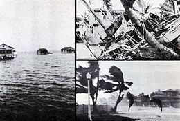
Early on September 17, the storm made landfall near West Palm Beach, Florida with winds of 145 mph (233 km/h). In the city, more than 1,711 homes were destroyed. Elsewhere in the county, impact was severest around Lake Okeechobee. The storm surge caused water to pour out of the southern edge of the lake, flooding hundreds of square miles as high as 20 feet (6.1 m) above ground. Numerous houses and buildings were swept away in the cities of Belle Glade, Canal Point, Chosen, Pahokee, and South Bay. At least 2,500 people drowned, while damage was estimated at $25 million. While crossing Florida, the system weakened significantly, falling to Category 1 intensity late on September 17. It curved north-northeastward and briefly re-emerged into the Atlantic on September 18, but soon made another landfall near Edisto Island, South Carolina with winds of 85 mph (140 km/h). Early on the following day, the system weakened to a tropical storm and became extratropical over North Carolina hours later. Overall, the system caused $100 million in damage and at least 4,078 deaths.
Meteorological history
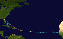
The storm was first observed 900 miles (1450 km) to the east of Guadeloupe on September 10 by the S.S. Commack. At the time, this was the most easterly report of a tropical cyclone ever received through ship's radio.[1] A Cape Verde-type hurricane, hurricane analysis in the 1990s determined the storm likely formed four days prior between Cape Verde and the coast of Africa.[2]
| Rank | Hurricane | Season | Landfall pressure |
|---|---|---|---|
| 1 | "Labor Day" | 1935 | 892 mbar (hPa) |
| 2 | Camille | 1969 | 900 mbar (hPa) |
| 3 | Katrina | 2005 | 920 mbar (hPa) |
| 4 | Andrew | 1992 | 922 mbar (hPa) |
| 5 | "Indianola" | 1886 | 925 mbar (hPa) |
| 6 | "Florida Keys" | 1919 | 927 mbar (hPa) |
| 7 | "Okeechobee" | 1928 | 929 mbar (hPa) |
| 8 | "Great Miami" | 1926 | 930 mbar (hPa) |
| Donna | 1960 | 930 mbar (hPa) | |
| 10 | Carla | 1961 | 931 mbar (hPa) |
| Source: HURDAT,[2] Hurricane Research Division[3] | |||
As the storm neared the Caribbean, it was already a Category 3 hurricane.[2] On September 12, the strengthening storm passed over Guadeloupe, its eye centering over Pointe-à-Pitre between 1830–1930 UTC, with winds of 140 mph (230 km/h). It then passed south of the other Leeward Islands while continuing to strengthen. Guadeloupe reported a pressure of 27.76 inHg (940 mbar), and a ship just south of St. Croix in the United States Virgin Islands reported it as an even stronger storm with a pressure of 27.50 inHg (931 mbar).[1] On the 13th the storm struck Puerto Rico directly as a Category 5 hurricane, allegedly packing winds of 160 mph (260 km/h);[2] reliable reports from San Juan placed the wind speed at 125 knots (145 mph, 230 km/h), and a report from Guayama placed the pressure at 27.65 inHg (936 mbar).[1] The 160 mph (260 km/h) wind measurement from Puerto Rico was taken by a cup anemometer in San Juan, 30 miles (50 km) north of the storm's center, which measured 160 mph (260 km/h) sustained winds three hours before the peak wind speed was reached; however, the instrument was destroyed soon after and could not be calibrated. This unverified reading was the strongest wind measurement ever reported for an Atlantic hurricane up until that time.[4]
The hurricane was also extremely large as it crossed Puerto Rico. Hurricane-force winds were measured in Guayama for 18 hours; since the storm is estimated to have been moving at 13 mph (21 km/h), the diameter of the storm's hurricane winds was estimated very roughly to be 234 miles (376 km).[5] After leaving the Caribbean, the hurricane moved across the Bahamas as a strong Category 4 hurricane. It continued to the west-northwest, and made landfall in southern Florida at 00 UTC on September 17 (7:00 p.m. local time on September 16).[2] Initially, Richard Gray of the U.S. Weather Bureau was optimistic that the storm would spare the south Florida region.[6] Atmospheric pressure at landfall was measured at 929 mbar (hPa),[7] and maximum sustained winds were near 145 mph (233 km/h).[2] The eye passed ashore in Palm Beach County near West Palm Beach, then moved directly over Lake Okeechobee.[2] Peak gusts were estimated near 160 mph (260 km/h) at Canal Point.[1] The hurricane's path turned northeast as it crossed Florida, taking it across northern Florida, eastern Georgia, and the Carolinas on September 19. It then moved inland and merged with a low-pressure system around Toronto on the 20th.[2]
Impact
Leeward Islands
| Storm Deaths by Region | |||
|---|---|---|---|
| Region | Deaths | Locale | Deaths |
| Caribbean and Bahamas |
1575[8] | Martinique | 3 |
| Guadeloupe | 1200 | ||
| Montserrat | 42[9] | ||
| Nevis | 3[10] | ||
| Puerto Rico | 312 | ||
| Bahamas | 18 | ||
| United States | 2500+[11] | Florida | 2500+ |
| Total | 4078+ | ||
The hurricane moved directly over the Leeward Islands in the Caribbean Sea, strengthening as it did so. On the island of Dominica winds were clocked at 24 mph (39 km/h); there were no reports of damages.[1] In Martinique, even further south of the storm's path, there were three fatalities. Guadeloupe received a direct hit from the storm, apparently with little warning; the death toll there was 1200,[8] and damage reports relayed through Paris indicated "great destruction" on the island.[1] Approximately 85%-95% of banana crops were destroyed, 70%-80% of tree crops suffered severe damage, and 40% of sugar cane was completed ruined.[12]
Montserrat, just north of the storm's center, was warned in advance of the storm but still suffered £150,000 (1928 UKP) in damages and 42 deaths; Plymouth and Salem were devastated and crop losses caused near-starvation conditions before relief could arrive.[9] The storm passed to the south of the islands of St. Kitts and St. Croix, which suffered heavy damages to property and crops but no reported fatalities.[1] Nevis also reported three deaths due to the storm.[10]
Puerto Rico
The island of Puerto Rico received the worst of the storm's winds when the hurricane moved directly across the island at Category 5 strength. The island knew of the storm's approach well ahead of time; by about 36 hours in advance all police districts were warned and radio broadcasts provided constant warnings to ships. Effective preparation is credited for the relatively low death toll of 312, and not a single ship was lost at sea in the vicinity of Puerto Rico. By comparison, the weaker 1899 Hurricane San Ciriaco killed approximately 3,000 people.[5]
The storm was named the San Felipe II Hurricane because the eye of the cyclone made landfall on the Christian feast day of Saint Philip.[13] It was named "Segundo", Spanish for "the Second", because of another destructive "Hurricane San Felipe" which struck Puerto Rico on that same day in 1876.[14] Since European arrival in the Americas in 1492 all storms and hurricanes were named after the name of the saint of the day the storm hit Puerto Rico.[15] In 1953 that the United States started naming hurricanes by female names until 1978 when both gender names began to be used.[15] Yet it was only in 1960 that hurricanes stopped being officially named after Saints.[15]
San Felipe II is officially classified as Puerto Rico's biggest, worst, and most devastating hurricane to ever have impacted the island.[13] Even though it was the worst hurricane to hit the island, others such as the San Ciriaco Hurricane caused more deaths. The first warning the Island received was by the steamship Commack on latitude 17° north and longitude 48° West. San Felipe entered the island early in the morning of Thursday September 13, with its eye close to Guayama and it traversed the island in a north-west direction, leaving between the towns of Aguadilla and Isabela. The eye of the hurricane made its Puerto Rico crossing in eight hours, moving at about 13 mph (21 km/h). In Guayama, located in south eastern Puerto Rico, the lowest recording of the storm was taken; 27.5 inHg (930 mbar) at 2:30 p.m.[13]
Rainfall
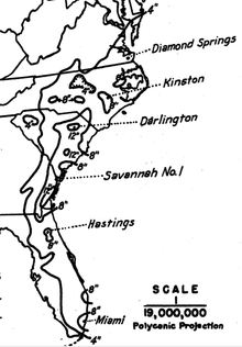
The rainfall recorded on September 13–14, 1928, are records for the maximum of rainfall associated with a hurricane in Puerto Rico within a period of forty-eight hours.[13] In those regions where precipitation is more common place, as in Adjuntas in the Cordillera Central and in the Sierra de Luquillo, the rain was over 25 inches (640 mm), with 29.60 inches (752 mm) recorded in Adjuntas.[13]
Wind
The anemometer located in Puerta de Tierra lost one of its cups at 11:44 am on the September 13, just when it had registered a maximum speed of 150 miles (240 km) per hour, a speed that was sustained for five consecutive minutes. Previously the same instrument had measured 160 miles (260 km) per hour for one minute.[13] The city of San Juan was 30 miles (48 km) away from the eye of San Felipe when those measurements were recorded—because of which, at the time, it seemed possible that some estimates of 200 miles (320 km) per hour near the center of the storm were not overdrawn.[13]
Damage
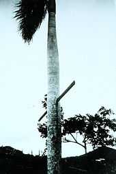
There was general destruction through the island, with the towns where the eye passed being swept away.[13] Property damage on the island from winds and rain was catastrophic. The northeast portion of the island received winds in excess of Category 3 strength, with hurricane-force winds lasting as long as 18 hours. Official reports stated "several hundred thousand" people were left homeless, and property damages were estimated at $50 million.[5][16]
In the island there was no building that was not affected.[13] Some sugar mills ("Centrales") that had cost millions of dollars to build were reduced to rubble. Reports say that 24,728 homes were completely destroyed and 192,444 were partially destroyed.[13] Most of the sugarcane fields were flooded, thus losing the year's crops. Half of the coffee plants and half of the shade trees that covered these were destroyed; almost all of the coffee harvest was lost. The coffee industry would take years to recover since coffee needs shade trees to grow. The tobacco farms also had great losses. After this hurricane, Puerto Rico never regained its position as a coffee exporter.[17]
Communications were impacted by fallen trees, landslides, and debilitated bridges. Of the school buildings 770 were destroyed or debilitated. According to some estimates of the day, excluding personal losses, the damages reached $85.312 million and over 500,000 people were left homeless.[13]
Bahamas
| Rank | Hurricane | Season | Fatalities |
|---|---|---|---|
| 1 | "Great Hurricane" | 1780 | 22,000+ |
| 2 | Mitch | 1998 | 19,325+ |
| 3 | "Galveston" | 1900 | 8,000 – 12,000 |
| 4 | Fifi | 1974 | 8,000 – 10,000 |
| 5 | "Dominican Republic" | 1930 | 2,000 – 8,000 |
| 6 | Flora | 1963 | 7,186 – 8,000 |
| 7 | "Pointe-à-Pitre" | 1776 | 6,000+ |
| 8 | "Newfoundland" | 1775 | 4,000 – 4,163 |
| 9 | "Okeechobee" | 1928 | 4,075+ |
| 10 | "Monterrey" | 1909 | 4,000 |
The eye of the hurricane passed over much of the island chain as a strong Category 4 hurricane, again causing very heavy damage. As in Puerto Rico, however, authorities in the Bahamas had ample warning of the hurricane's approach, and preparations minimized the loss of life in the islands. The only report of fatalities was from a sloop lost at sea in the vicinity of Ambergris Cay with 18 on board.[1]
In Nassau, some buildings which were recently repaired after the 1926 Nassau hurricane were destroyed during this storm. A 10-year old girl died after falling into an open trench filled with water and drowning. At the Fort Montague Hotel, the windows, doors, and furniture were badly damaged. Similar impact was reported at the Royal Victoria Hotel, though little impact was inflicted at the British Colonial Hotel. However, the gardens of the three hotels were "damaged almost beyond recognition".
On Bimini, sustained winds of 140 mph (230 km/h) were observed, causing major damage to buildings. Ninety-five houses and some other buildings, including a few churches and government buildings, were damaged or destroyed on Eleuthera. Minor damage was reported on Rum Cay. Most of the food crops were completely destroyed. On San Salvador Island, four buildings were demolished, including two churches, while several other structures suffered minor damage. Food crops were nearly wiped out.
South Florida

Coastal damage in Florida near the point of landfall was catastrophic. Miami, well south of the point of landfall, escaped with very little damage; Hollywood and Fort Lauderdale suffered only slight damages. In Fort Lauderdale, numerous power lines and telephone wires were downed.[18] Northward, from Pompano Beach to Jupiter, buildings suffered serious damage from the heavy winds and 10 ft (3 m) storm surge, which was heaviest in the vicinity of Palm Beach; total coastal damages were estimated as "several million" dollars.[1] In West Palm Beach, more than 1,711 homes were destroyed. At the Jupiter Inlet Lighthouse, the mortar was reportedly "squeezed ...like toothpaste" between the bricks during the storm, swaying the tower 17 inches (43 cm) off the base.[19] The lighthouse keeper, Captain Seabrook, and his son, Franklin, worked to keep the light on during the storm after the electricity went out. After the generator failed to work, they hand-cranked the light's mantle.[20] Because of well-issued hurricane warnings, residents were prepared for the storm, and the number of lives lost in the coastal Palm Beach area was only 26.[1]

Inland, the hurricane wreaked much more widespread destruction along the more heavily populated coast of Lake Okeechobee. Residents had been warned to evacuate the low ground earlier in the day, but after the hurricane did not arrive on schedule, many thought it had missed and returned to their homes. When the worst of the storm crossed the lake, the south-blowing wind caused a storm surge to overflow the small dike that had been built at the south end of the lake. The resulting flood covered an area of hundreds of square miles with water that in some places was over 20 ft (6 m) deep. Houses were floated off of their foundations and dashed to pieces against any obstacle they encountered.[21] Most survivors and bodies were washed out into the Everglades where many of the bodies were never found. As the rear eyewall passed over the area, the flood reversed itself, breaking the dikes along the northern coast of the lake and causing a similar but smaller flood.
Floodwaters persisted for several weeks, greatly impeding attempts to clean up the devastation. Burial services were quickly overwhelmed, and many of the bodies were placed into mass graves. Around 75% of the fatalities were migrant farm workers, making identification of both dead and missing bodies very difficult; as a result of this, the count of the dead is not very accurate. The Red Cross estimated the number of fatalities as 1,836, which was taken as the official count by the National Weather Service for many years (and exactly equal to the official count for Hurricane Katrina). Older sources usually list 3,411 as the hurricane's total count of fatalities, including the Caribbean. However, in 2003 the U.S. death count was revised as "at least" 2,500, making the Okeechobee hurricane the second-deadliest natural disaster in United States history behind the Galveston Hurricane of 1900. A mass grave at the Port Mayaca Cemetery east of Port Mayaca contains the bodies of 1,600 victims of the hurricane.[22]
Thousands of people were left homeless in Florida; property damage was estimated at $25 million ($343 million). It is estimated if a similar storm were to strike as of the year 2003, it would cause $18.7 billion in damages. The cyclone remains one of three Atlantic hurricanes to strike the southern mainland of Florida with a central pressure below 940 mbar (27.76 inHg), the others being the 1926 Miami hurricane and Hurricane Andrew of 1992.[23]
Elsewhere
Heavy rainfall fell from eastern Florida through coastal Georgia, the Carolinas, and southeast Virginia. The highest rain amount reported was 12.53 inches (318 mm) at Darlington, South Carolina.[24] The storm caused flooding in North Carolina and brought near-hurricane-force winds and a 7 foot (2.1 m) storm surge to the Norfolk area.[25] Nonetheless, most sources agree that the hurricane caused only minimal damage in these areas.[1]
Aftermath
| Rank | Hurricane | Season | Fatalities |
|---|---|---|---|
| 1 | "Galveston" | 1900 | 8,000–12,000† |
| 2 | "Okeechobee" | 1928 | 2,500+† |
| 3 | Katrina | 2005 | 1,836 |
| 4 | "Cheniere Caminada" | 1893 | 1,100–1,400* |
| 5 | "Sea Islands" | 1893 | 1,000–2,000† |
| 6 | "Florida Keys" | 1919 | 778 |
| 7 | "Georgia" | 1881 | 700† |
| 8 | Audrey | 1957 | 416 |
| 9 | "Labor Day" | 1935 | 408 |
| 10 | "Last Island" | 1856 | 400† |
| †estimated total Reference: Deadliest US hurricanes[26] | |||
Racial issues
In Florida, although the hurricane destroyed everything in its path with impartiality, the death toll was by far highest in the economically poor areas in the low-lying ground right around Lake Okeechobee. Around 75% of the fatalities were among migrant farm workers, most of whom were black. Black workers did most of the cleanup, and the few caskets available for burials were mostly used for the bodies of whites; other bodies were either burned or buried in mass graves. Burials were segregated, and the only mass gravesite to receive a memorial contained only white bodies.[27][28] The inequity has caused ongoing racial friction that still exists. The effects of the hurricane on black migrant workers is dramatized in Zora Neale Hurston's novel Their Eyes Were Watching God.
Improved building codes
In the aftermath of the hurricane in coastal Florida, it became apparent that well-constructed buildings with shutters had suffered practically no damage from winds that caused serious structural problems to lesser buildings. Buildings with well-constructed frames, and those made of steel, concrete, brick, or stone were largely immune to winds, and the use of shutters prevented damage to windows and the interior of the buildings. Coming on the heels of the 1926 Miami hurricane where a similar pattern had been noticed, one lasting result of the 1928 storm was improved building codes.[29]
Flood control

To prevent a recurrence of disasters like this one and the Great Miami Hurricane of 1926, the Florida State Legislature created the Okeechobee Flood Control District, which was authorized to cooperate with the U.S. Army Corps of Engineers in flood control undertakings.[30] After a personal inspection of the area by President Herbert Hoover, the Corps drafted a new plan which provided for the construction of floodway channels, control gates, and major levees along Lake Okeechobee's shores. A long term system was designed for the purpose of flood control, water conservation, prevention of saltwater intrusion, and preservation of fish and wildlife populations.[30] One of the solutions was the construction of the Herbert Hoover Dike. Today, concerns related to the dike's stability have grown in response to studies indicating long term problems with "piping" and erosion. Leaks have been reported after several heavy rain events. Proposed solutions to the dike's problems have included the construction of a seepage berm on the landward side of the dike, with the first stage costing approximately $67 million (US$).[31]
See also
- Hurricane of 1928 African American Mass Burial Site
- List of Atlantic hurricanes
- List of Category 5 Atlantic hurricanes
- List of Florida hurricanes
References
- ↑ 1.0 1.1 1.2 1.3 1.4 1.5 1.6 1.7 1.8 1.9 1.10 Charles L. Mitchell (December 8, 1928). "The West Indian Hurricane of September 10–20, 1928" (PDF). Monthly Weather Review (American Meteorological Society) 56 (9): 347–350. Bibcode:1928MWRv...56..347M. doi:10.1175/1520-0493(1928)56<347:TWIHOS>2.0.CO;2. Retrieved April 29, 2010.
- ↑ 2.0 2.1 2.2 2.3 2.4 2.5 2.6 2.7 National Hurricane Center; Hurricane Research Division (March 2, 2015). "Atlantic hurricane best track (HURDAT version 2)". United States National Oceanic and Atmospheric Administration. Retrieved April 24, 2015.
- ↑ National Hurricane Center; Hurricane Research Division; Atlantic Oceanographic and Meteorological Laboratory (February 2015). "Continental United States Hurricanes (Detailed Description)". aoml.noaa.gov. Miami: United States National Oceanic and Atmospheric Administration's Office of Oceanic & Atmospheric Research. Retrieved April 24, 2015.
- ↑ Steve Feuer, Ramon Perez Suarez, Ricardo Prieto, and Jorge Sanchez-Sesma (March 2009). "Documentation of Atlantic Tropical Cyclones Changes in HURDAT: Hurricane No. 10 in 1924". Hurricane Research Division. Retrieved March 21, 2009.
- ↑ 5.0 5.1 5.2 Oliver L. Fassig (December 8, 1928). "San Felipe–The Hurricane of September 13, 1928, at San Juan, P.R" (PDF). Monthly Weather Review (American Meteorological Society) 56 (9): 350–352. Bibcode:1928MWRv...56..350F. doi:10.1175/1520-0493(1928)56<350:SFHOSA>2.0.CO;2. Retrieved April 29, 2010.
- ↑ Eliot Kleinberg (2003). Black Cloud: The Great Florida Storm of 1928. Carroll & Graf Publishers. p. 87. ISBN 978-0-7867-1146-8.
- ↑ David A. Glenn (2005). "A Reanalysis of the 1916, 1918, 1927, 1928, and 1935 Tropical Cyclones of the North Atlantic Basin" (PDF). National Oceanic and Atmospheric Administration. Archived (PDF) from the original on February 16, 2008. Retrieved January 13, 2008.
- ↑ 8.0 8.1 National Hurricane Center (1995–1997). "The Deadliest Atlantic Tropical Cyclones, 1492–1996". National Oceanic and Atmospheric Administration. Archived from the original on January 28, 2008. Retrieved January 14, 2008.
- ↑ 9.0 9.1 William G. Innanen. "A Condensed History of Montserrat". Archived from the original on February 12, 2006. Retrieved February 27, 2006.
- ↑ 10.0 10.1 Hubbard, Vincent K. (2002). Swords, Ships & Sugar: History of Nevis. Corvallis, Oregon
- ↑ Chris Landsea, NHC. "FAQ E12: For the USA, what are the 30 highest death toll hurricanes on record?". National Oceanic and Atmospheric Administration. Archived from the original on December 25, 2007. Retrieved January 14, 2008.
- ↑ Don R. Hoy (1961). Agricultural Land Use of Guadeloupe, Issue 12. Washington, D.C.: National Academies Press. p. 64. Retrieved March 15, 2014.
- ↑ 13.0 13.1 13.2 13.3 13.4 13.5 13.6 13.7 13.8 13.9 13.10 Mújica-Baker, Frank. Huracanes y Tormentas que han afectado a Puerto Rico (PDF). Estado Libre Asociado de Puerto Rico, Agencia Estatal para el manejo de Emergencias y Administración de Desastres. p. 10. Retrieved August 30, 2010.
- ↑ Mújica-Baker, Frank. Huracanes y Tormentas que han afectado a Puerto Rico (PDF). Estado Libre Asociado de Puerto Rico, Agencia Estatal para el manejo de Emergencias y Administración de Desastres. p. 9. Retrieved August 30, 2010.
- ↑ 15.0 15.1 15.2 Mújica-Baker, Frank. Huracanes y Tormentas que han afectado a Puerto Rico (PDF). Estado Libre Asociado de Puerto Rico, Agencia Estatal para el manejo de Emergencias y Administración de Desastres. p. 4. Retrieved August 30, 2010.
- ↑ U.S. Southern Command. "Hurricane Preparedness: History". U.S. Army. Archived from the original on December 17, 2007. Retrieved January 14, 2008.
- ↑ "Stuart B. Schwartz. ''The 1928 Hurricane and the Shaping of the Circum-Caribbean Region.'' In, Revista: Harvard Review of Latin America. The David Rockefeller Center for Latin American Studies. Harvard University. Winter 2007.". Drclas.harvard.edu. Retrieved March 10, 2012.
- ↑ "Hurricane Hits City Sunday". Fort Lauderdale Daily News. 1928. Retrieved October 4, 2012.
- ↑ Barnes, p. 129
- ↑ "The Storm: 1928 Remembered (Teacher's Guide)" (PDF). Historical Society of Palm Beach County. 2008. p. 21. Retrieved March 10, 2015.
- ↑ Jeff Klinkenberg (July 12, 1992). "A storm of memories". St. Petersburg Times.
- ↑ Brochu, Nicole Sterghos (2003). "Florida's Forgotten Storm: the Hurricane of 1928". South Florida Sun-Sentinel. Retrieved April 6, 2008.
- ↑ Hurricane Research Division (2008). "All U.S. Hurricanes (1851–2007)". National Oceanic and Atmospheric Administration. Retrieved April 6, 2008.
- ↑ United States Corp of Engineers (1945). Storm Total Rainfall In The United States. War Department. p. SA 2-15.
- ↑ David Roth and Hugh Cobb. "Virginia Hurricane History". National Oceanic and Atmospheric Administration. Archived from the original on January 8, 2008. Retrieved January 14, 2008.
- ↑ Blake, Eric S; Landsea, Christopher W; Gibney, Ethan J; National Climatic Data Center; National Hurricane Center (August 10, 2011). The deadliest, costliest and most intense United States tropical cyclones from 1851 to 2010 (and other frequently requested hurricane facts) (PDF) (NOAA Technical Memorandum NWS NHC-6). National Oceanic and Atmospheric Administration. p. 47. Retrieved August 10, 2011.
- ↑ Deborah Sharp (September 4, 2003). "Storm's path remains scarred after 75 years". USA Today. Retrieved March 10, 2015.
- ↑ Eliot Kleinberg (June 1, 2003). "The storm of 1928: Dead-on devastation". Palm Beach Post. Retrieved February 23, 2006.
- ↑ Betty Nelander (2008). "The Hurricane of 1928: Category 4 hurricane scarred Palm Beach". Archived from the original on September 20, 2008. Retrieved June 27, 2008.
- ↑ 30.0 30.1 "Lake Okeechobee and The Okeechobee Waterway". U.S. Army Corps of Engineers South Florida Operations Office. Archived from the original on June 9, 2007. Retrieved August 3, 2008.
- ↑ "Lake Okeechobee and the Herbert Hoover Dike" (PDF). U.S. Army Corps of Engineers Jacksonville District. Archived from the original (PDF) on October 3, 2008. Retrieved August 3, 2008.
External links
| Wikimedia Commons has media related to Okeechobee Hurricane of 1928. |
- Florida's Forgotten Hurricane
- NOAA Okeechobee Hurricane Memorial
- Historic Images of Florida Hurricanes (Florida State Archives)
- Footage of storm damage
| ||||||||||||||||||||||||||||||||||||||