1922 Atlantic hurricane season
| |
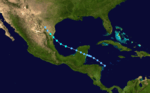
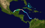
| Season summary map |
| First system formed |
May 12, 1922 |
| Last system dissipated |
October 31, 1922 |
| Strongest storm |
Two – 960 mbar (hPa) (28.36 inHg), 120 mph (195 km/h) |
| Total storms |
5 |
| Hurricanes |
3 |
| Major hurricanes (Cat. 3+) |
1 |
| Total fatalities |
Unknown |
| Total damage |
Unknown |
Atlantic hurricane seasons
1920, 1921, 1922, 1923, 1924 |
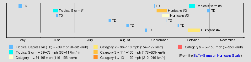
The 1922 Atlantic hurricane season ran through the summer and the first half of fall in 1922. The season was a quiet one, with only five tropical cyclones forming during the course of the season. The first was a tropical storm that passed over the Yucatán Peninsula and later made another landfall in rural northeast Mexico. The second was a hurricane, the strongest one of the season. It formed near Cape Verde and curved out into the Atlantic. It grazed the Leeward Islands and battered Bermuda, passing just offshore as a Category 3. The hurricane became extratropical soon after it passed Bermuda. The third was a tropical storm that passed over Cuba and made landfall near Pensacola, Florida. The last storm of the season was a Category 2 hurricane that made landfall near Cancún, Mexico. The hurricane weakened in the Bay of Campeche and dissipated just offshore. A fifth storm was found in reanalysis in 2009.
Timeline
Storms
Tropical Storm One
| Tropical storm (SSHWS) |
|
|
| Duration |
June 12 – June 16 |
| Peak intensity |
50 mph (85 km/h) (1-min) <1003 mbar (hPa) |
The first storm of the season formed off Cabo Gracias, Nicaragua on June 12 and moved generally northwestward. The storm strengthened very little before hitting the central Yucatan Peninsula. Once it emerged into the Gulf of Mexico, it began to grow in intensity. The Monthly Weather Review says the storm resembled a developing hurricane. According to the Best Track data, however, winds never exceeded 50 mph (80 km/h). Landfall in mainland Mexico stopped the intensification. It came ashore in a sparsely populated area near the village of La Pesca, about 150 miles (240 km) south of the mouth of the Rio Grande. The storm brought very heavy rain to the Rio Grande Valley that caused significant flooding, but no fatalities were reported.
Hurricane Two
| Category 3 hurricane (SSHWS) |
|
|
| Duration |
September 13 – September 22 |
| Peak intensity |
120 mph (195 km/h) (1-min) 960 mbar (hPa) |
By far the most powerful storm of the season, this hurricane formed well east of the Windward Islands and moved northwestward steadily strengthening. It grazed the Leeward Islands as a Category 2 hurricane and began to recurve shortly thereafter. During this recurvature, it strengthened into a Category 3 storm, eventually attaining winds of 120 mph (190 km/h). It would maintain Category 3 intensity for the next four days until it became extratropical on September 23. The storm passed almost directly over Bermuda early on September 21, buffeting the island with 115 mph (185 km/h) winds and an eight-foot storm surge. As the center of this hurricane passed Bermuda to the southeast, a lull occurred on the island for an hour around 9 am on September 21. The lowest pressure measured was 968 mbar (28.57 inHg). Significant damage occurred there, as winds peaked at 120 mph (190 km/h). It was Bermuda's highest tide since the hurricane of 1899.[1] The hurricane remains the strongest Atlantic tropical cyclone above 30.4°N, since Hurricane Dog of 1950 weakened to below 150 mph (240 km/h) as it reached that latitude.[2]
Hurricane Three
| Category 1 hurricane (SSHWS) |
|
|
| Duration |
September 18 – September 24 |
| Peak intensity |
80 mph (130 km/h) (1-min) <987 mbar (hPa) |
A tropical storm formed off the east coast of Florida on September 18. It moved towards the northeast and became a minimal hurricane well off the coast of North Carolina on September 21. It weakened as it moved into the open Atlantic.
This hurricane was not discovered until reanalysis in 2009.
Hurricane Four
| Category 2 hurricane (SSHWS) |
|
|
| Duration |
October 11 – October 22 |
| Peak intensity |
110 mph (175 km/h) (1-min) <984 mbar (hPa) |
Early on October 12, a low pressure area was detected by the S.S. Chalmette in the western Caribbean Sea,[3] and the system is believed to have organized to a minimal tropical storm 260 miles (420 km) southwest of Kingston, Jamaica late on October 13.[2] The cyclone slowly moved northwest, and it gradually intensified on October 15. On the evening of October 16, the tropical storm rapidly intensified, and it strengthened to the equivalent of a category 2 hurricane on October 17. Later, it attained peak sustained winds of 110 mph (175 km/h).[2] Early on October 18, a ship reported a minimum pressure of 984 mbar (29.06 inHg) near the center, which was the lowest pressure measured during the life span of the storm.[3] Subsequently, the hurricane weakened, and it made landfall 10 miles (16 km) south of Cancún with winds of 80 mph (130 km/h).[2] It crossed the peninsula and moved south along the coast, weakening to a minimal tropical storm and striking the Tabasco area. The storm caused significant property damage and shipping losses. Several fishing vessels sank and some ocean liners (including the now-infamous Morro Castle) were stranded outside Vera Cruz harbor because violent seas made it too dangerous to enter. There were a few fatalities in the Yucatan, where damage to buildings and crops was severe.
Tropical Storm Five
| Tropical storm (SSHWS) |
|
|
| Duration |
October 12 – October 17 |
| Peak intensity |
50 mph (85 km/h) (1-min) <1000 mbar (hPa) |
Storm Five formed of the northern coast of Honduras on October 12 and turned northwestward. The storm strengthened very little during its lifetime, striking western Cuba with only 45 mph (72 km/h) sustained winds. It reached its peak intensity of 50 mph (80 km/h) in the Gulf of Mexico. It held this intensity for two days, weakening just before landfall near Orange Beach, Alabama. The storm dissipated quickly inland. It may have been a subtropical storm due to some hybrid characteristics.[2]
See also
References
Printed media
- Terry Tucker. Beware the Hurricane! Hamilton Press: Bermuda, 1966.
External links