1920 Atlantic hurricane season
| |
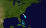
| Season summary map |
| First system formed |
September 7 |
| Last system dissipated |
October 27 |
| Strongest storm |
One – 110 mph (175 km/h) (1-minute sustained) |
| Total storms |
5 |
| Hurricanes |
4 |
| Total fatalities |
1 direct, 1 indirect |
| Total damage |
≥ $1.45 million (1920 USD) |
Atlantic hurricane seasons
1918, 1919, 1920, 1921, 1922 |
The 1920 Atlantic hurricane season ran through the summer and the first half of fall in 1920. The season was below average with only five tropical cyclones forming in the Atlantic Basin. It had one of the shortest seasons of duration, with the activity occurring in a 23 day period. All but one of them were hurricanes but none reached major hurricane status (Category 3 or above).
Timeline

Storms
Hurricane One
| Category 2 hurricane (SSHWS) |
|
|
| Duration |
September 7 – September 14 |
| Peak intensity |
110 mph (175 km/h) (1-min) <985 mbar (hPa) |
The first known storm of the season was first identified on September 7 as a 40 mph (65 km/h) tropical storm over Atlantic Ocean. Traveling towards the northwest, the storm gradually intensified, attaining hurricane-status late on September 9.[1] The following day, a ship in the vicinity of the storm recorded a pressure of 985 mbar (hPa), the lowest pressure recorded in relation to the storm.[2] Around 1200 UTC, the hurricane turned towards the north and intensified into a modern day Category 2 hurricane on the Saffir-Simpson Hurricane Scale early on September 11. The storm continued to intensify through September 12 when it reached its peak intensity with winds of 110 mph (175 km/h). After maintaining this intensity for 18 hours, the hurricane began to weaken as it turned towards the northwest. By 0000 UTC on September 14, the storm weakened to a Category 1 hurricane. The system began to undergo an extratropical transition, completing the process early the next day. The system tracked nearly due east before dissipating on September 16 to the north of the Azores islands.[1]
Hurricane Two
| Category 2 hurricane (SSHWS) |
|
|
| Duration |
September 16 – September 23 |
| Peak intensity |
100 mph (155 km/h) (1-min) 975 mbar (hPa) |
The second hurricane, a Category 2, struck Central America and Cozumel, Mexico as a tropical storm and made landfall near Dulac, Louisiana, causing over $1 million in damage and one death.
Hurricane Three
| Category 1 hurricane (SSHWS) |
|
|
| Duration |
September 19 – September 24 |
| Peak intensity |
85 mph (140 km/h) (1-min) |
Hurricane Three, a Category 1, formed on September 19, and moved very slowly as it looped toward North Carolina. Shortly before landfall, it had become a hurricane, and then struck Cape Fear, North Carolina.
Tropical Storm Four
| Tropical storm (SSHWS) |
|
|
| Duration |
September 23 – September 27 |
| Peak intensity |
45 mph (75 km/h) (1-min) <1009 mbar (hPa) |
This storm formed in the open Atlantic and dissipated four days later.
Hurricane Five
| Category 1 hurricane (SSHWS) |
|
|
| Duration |
September 25 – September 30 |
| Peak intensity |
85 mph (140 km/h) (1-min) <987 mbar (hPa) |
The first indications of another tropical cyclone developing were on September 24 near southeast Florida.[3] The system tracked in a general westward direction and entered the Gulf of Mexico the following day. Not long after entering the gulf, it was designated as a tropical depression, with winds estimated at 30 mph (45 km/h). Turning towards the south-southwest, the storm gradually intensified, attaining tropical storm-status on September 27. The next day, the storm nearly stalled close to the center of the gulf.[1] On September 28, further development of the storm took place and ships in the vicinity of the storm reported a strong gale had formed.[4] The next day, the storm strengthened into a modern day Category 1 hurricane on the Saffir-Simpson Hurricane Scale with winds of 80 mph (130 km/h).[1] Several hours later, nearby ship reported a pressure of 987 mbar (hPa), the lowest pressure recorded in relation to the hurricane.[3] Around this time, the storm reached its peak intensity with winds of 85 mph (140 km/h); the storm also began to turn towards the northeast at this time.[1] Not long after reaching its peak intensity, the forward motion of the storm quickly increased as the hurricane weakened.[4] Early on September 30, the storm made landfall near Cedar Key, Florida with winds up to 65 mph (100 km/h) before transitioning into an extratropical cyclone over the Florida Peninsula. Later that day, the cyclone dissipated over the eastern Atlantic Ocean.[1][4]
Although the storm weakened significantly before landfall, it caused severe damage along the immediate coastlines of western Florida. Low lands along the coast were inundated by storm surge and heavy rains, peaking at 8 in (203.2 mm), flooded croplands, causing substantial damage to the fruit industry. One person was killed after being electrocuted by a downed wire in St. Petersburg. Several ships were also destroyed by the storm while docked along the coast.[4]
See also
References
External links