1859 Atlantic hurricane season
| |
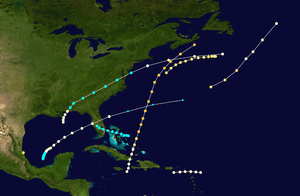
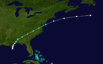
| Season summary map |
| First system formed |
July 1, 1859 |
| Last system dissipated |
October 29, 1859 |
| Strongest storm |
Hurricane Six – 938 mbar (hPa) (27.71 inHg), 130 mph (215 km/h) |
| Total depressions |
8 |
| Total storms |
8 |
| Hurricanes |
7 |
| Total fatalities |
Numerous at sea |
| Total damage |
Unknown |
Atlantic hurricane seasons
1857, 1858, 1859, 1860, 1861 |
The 1859 Atlantic hurricane season featured seven hurricanes, the most recorded during an Atlantic hurricane season until 1870. However, in the absence of modern satellite and other remote-sensing technologies, only storms that affected populated land areas or encountered ships at sea were recorded, so the actual total could be higher. An undercount bias of zero to six tropical cyclones per year between 1851 and 1885 has been estimated.[1] Of the eight known 1859 cyclones, five were first documented in 1995 by Jose Fernandez-Partagas and Henry Diaz, which was largely adopted by the National Oceanic and Atmospheric Administration's Atlantic hurricane reanalysis in their updates to the Atlantic hurricane database (HURDAT), with some adjustments. HURDAT is the official source for hurricane data such as track and intensity, although due to sparse records, listings on some storms are incomplete.
The first tropical cyclone was a hurricane observed in the Tuxpan area of Veracruz on July 1. Hurricane conditions were observed along the coast and several vessels were lost. After no tropical cyclogenesis for over a month and a half, the next hurricane was spotted southeast of New England on August 17. The storm remained inconsequential and was last noted offshore Atlantic Canada about two days later. On September 2, another hurricane struck Saint Kitts and Saint Croix, damaging ships on the former.
The season's activity was reflected with an accumulated cyclone energy (ACE) rating of 56.[2] ACE is, broadly speaking, a measure of the power of the hurricane multiplied by the length of time it existed, so storms that last a long time, as well as particularly strong hurricanes, have high ACEs. It is only calculated for full advisories on tropical systems at or exceeding 39 mph (63 km/h), which is tropical storm strength.[3]
Storms
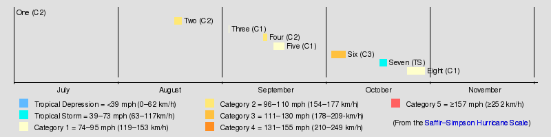
Hurricane One
| Category 2 hurricane (SSHWS) |
|
|
| Duration |
July 1 – July 1 |
| Peak intensity |
105 mph (165 km/h) (1-min) |
Little is known about the first tropical cyclone of the 1859 season, which was first analyzed in 1995 hurricane reanalysis.[4] Sometime in late June or early July, cities along the coastal Mexican state of Veracruz experienced a formidable hurricane, and several ships on the Gulf of Mexico were lost. Due to a lack of reports, the storm's listing in the Atlantic hurricane database is limited to a single point near Tuxpan, Veracruz on July 1, although this date was chiefly chosen as a placeholder in lieu of definitive data.[5][6]
Hurricane Two
| Category 2 hurricane (SSHWS) |
|
|
| Duration |
August 17 – August 19 |
| Peak intensity |
105 mph (165 km/h) (1-min) 982 mbar (hPa) |
Another hurricane discovered in contemporary reanalysis existed in the western Atlantic in the middle of August. Reports from two vessels in the vicinity of bad weather were the only evidence of the storm. One vessel, the Tornado, encountered severe winds, starting on August 17, which forced her to abandon her easterly course and sail into New York. The Caure also experienced strong winds on August 18 and 19 with air pressure as low as 982 mb.[4][6] A standard wind–pressure relationship model for that value yields winds of 80 mph (130 km/h). The wind patterns reported by each ship indicate that neither vessel reached the storm's core, where winds are typically at their strongest. As a result, the system is estimated to have attained at least Category 2 intensity on the modern-day Saffir–Simpson Hurricane Scale.[6] Its approximate track follows an east-northeasterly trajectory.[5]
Hurricane Three
| Category 1 hurricane (SSHWS) |
|
|
| Duration |
September 2 – September 3 |
| Peak intensity |
80 mph (130 km/h) (1-min) |
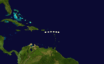
The first of three hurricanes in September was also the first of the season to be identified prior to 1995. It was described in a 1902 publication as a "mild" system which passed over St. Kitts, and later St. Croix, on September 2. A short track formulated for the storm in 1995 indicated a path across the northern Lesser Antilles on September 2; the track was shifted slightly toward the south for its inclusion within HURDAT.[5][7]
Hurricane Four
| Category 2 hurricane (SSHWS) |
|
|
| Duration |
September 12 – September 13 |
| Peak intensity |
105 mph (165 km/h) (1-min) |
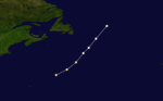
Based on reports of strong winds from a ship near 40°N, 50°W, Partagás documented another new storm near that point on September 12.[7] As with the previous hurricane, no track existed for this storm until the 2000 HURDAT, when more extensive observations from several additional vessels were utilized. At least four ships sustained structural damage or took on water, and the Bell Flower lost her captain and a crew member to the sea. The severity of the weather encountered by the ships suggested a cyclone of modest hurricane intensity.[5][6]
Hurricane Five
| Category 1 hurricane (SSHWS) |
|
|
| Duration |
September 15 – September 18 |
| Peak intensity |
80 mph (130 km/h) (1-min) 982[8] mbar (hPa) |
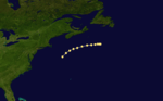
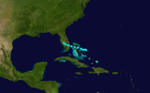
The fifth known storm of the season was first mentioned by David M. Ludlum in 1963 as having affected Mobile, Alabama on September 15, but with no description of its genesis or impacts.[9] Partagás also acknowledged the storm without attempting to reconstruct its track.[7][10] As a result, the cyclone was added to the hurricane database with only a single data point, placing it near Mobile as a Category 1 hurricane. The reanalysis project created a full track for the hurricane in 2003, using a multitude of newspaper accounts and reports from both land and sea to approximate its location and intensity.[6] Its known history now extends from September 15 through September 18. With winds of minimal hurricane strength, the storm approached the central Gulf Coast from the south-southwest, coming ashore early on September 16 over Alabama. It likely weakened into a tropical storm as it pushed inland, and traversed the Southeastern U.S. and Mid-Atlantic states. The storm reemerged into the Atlantic as it continued toward the northeast,[5] and based on ship reports, it is believed to have reattained hurricane intensity before passing south of New England and the Canadian Maritimes.[6]
The system brought hurricane-force winds to parts of Alabama and the Florida Panhandle.[8]
Hurricane Six
| Category 3 hurricane (SSHWS) |
|
|
| Duration |
October 2 – October 6 |
| Peak intensity |
125 mph (205 km/h) (1-min) 938[5] mbar (hPa) |
The final storm of the season documented prior to 1995 was first experienced by a ship east of Cuba on October 2. The reconstruction of its track indicates that the hurricane tracked northward over the extreme eastern tip of Cuba, bringing heavy weather to Baracoa before entering the southeastern Bahamas. The system severely impacted the Inagua region on October 2 and 3, destroying at least 25 boats. Several ships underway around Inagua endured rough seas and strong winds; "several of the crew and two soldiers" aboard one vessel wrecked by the hurricane died.[10] Meteorological reports from ships confirm that the hurricane continued northward, passing about midway between Bermuda and the East Coast of the United States. On October 6, a vessel near the center of the storm recorded a pressure of 938 mb, signalling an intense hurricane even after it crossed the 40th parallel north.[5][11] That pressure reading served as the basis for listing the system as the equivalence of a Category 3 hurricane.[6] Also on October 6, a ship near Sable Island encountered the storm, which likely continued to approach the Canadian Maritimes.[5][11] Officially, this hurricane was the strongest of the season.[5]
Tropical Storm Seven
| Tropical storm (SSHWS) |
|
|
| Duration |
October 16 – October 18 |
| Peak intensity |
70 mph (110 km/h) (1-min) 994 mbar (hPa) |
On October 17 and 18, ships throughout the central Bahamas experienced squally conditions accompanied by strong winds. One ship ran aground on Paradise Island, and another suffered similar a fate in the Abaco Islands. Based on those reports, Tropical Storm Seven was documented in 1995 as a westward-moving system which struck southern Florida on October 17.[11]
Hurricane Eight
| Category 1 hurricane (SSHWS) |
|
|
| Duration |
October 24 – October 29 |
| Peak intensity |
90 mph (150 km/h) (1-min) 989[5] mbar (hPa) |
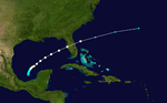
The final known storm of the season had a significant impact on maritime interests to the east of Florida on and around October 28, and at least one ship in the eastern Gulf of Mexico reported several hours of severe weather conditions on the same day. One ship capsized in the storm with all hands lost except one seaman, who was picked up on November 2 by a passing vessel. The survivor said he was stranded on the wreck for five days, indicating that his ship went down on October 28. At least four other ships in the region sustained appreciable structural damage, and stormy weather extended to as far away as the high seas around Bermuda by November 2. Partagás and Diaz used these reports to create a track for the storm, extending eastward from off the Atlantic coast of Florida on October 28 to southwest of Bermuda on November 2.[12] The storm's listing within HURDAT was later revised to show a tropical storm forming in the Bay of Campeche and tracking slowly toward the northeast. It then accelerated toward the east-northeast, crossing the Florida Peninsula on October 28, and reemerging into the Atlantic shortly thereafter.[5] Estimated to have reached hurricane strength based on a pressure reading of 989 mb,[6] the storm likely began to transition into an extratropical cyclone as it sped toward Bermuda faster than originally guessed; the storm's track now ends on October 29.[5]
See also
- List of Atlantic hurricane seasons
Notes
- ↑ Christopher W. Landsea (2004). "The Atlantic hurricane database re-analysis project: Documentation for the 1851–1910 alterations and additions to the HURDAT database". Hurricanes and Typhoons: Past, Present and Future. New York City, New York: Columbia University Press. pp. 177–221. ISBN 0-231-12388-4.
- ↑ Atlantic basin Comparison of Original and Revised HURDAT. Hurricane Research Division; Atlantic Oceanographic and Meteorological Laboratory (Report) (Miami, Florida: National Oceanic and Atmospheric Administration). February 2014. Retrieved July 13, 2014.
- ↑ David Levinson (August 20, 2008). 2005 Atlantic Ocean Tropical Cyclones. National Climatic Data Center (Report) (Asheville, North Carolina: National Oceanic and Atmospheric Administration). Archived from the original on June 29, 2011. Retrieved July 13, 2014.
- ↑ 4.0 4.1 Partagás and Diaz, p. 1
- ↑ 5.0 5.1 5.2 5.3 5.4 5.5 5.6 5.7 5.8 5.9 5.10 5.11 Hurricane Specialists Unit (2012). "Easy to Read HURDAT 1851–2012". National Hurricane Center. Retrieved January 2, 2013.
- ↑ 6.0 6.1 6.2 6.3 6.4 6.5 6.6 6.7 Hurricane Research Division (2011). "Documentation of Atlantic Tropical Cyclones Changes in HURDAT". National Oceanic and Atmospheric Administration. Retrieved January 2, 2013.
- ↑ 7.0 7.1 7.2 Partagás and Diaz, p. 2
- ↑ 8.0 8.1 Hurricane Research Division (2012). "Chronological List of All Continental United States Hurricanes: 1851-2011". National Hurricane Center. Retrieved January 2, 2013.
- ↑ Ludlum, p. 196
- ↑ 10.0 10.1 Partagás and Diaz, p. 4
- ↑ 11.0 11.1 11.2 Partagás and Diaz, p. 5
- ↑ Partagás and Diaz, p. 6
References