1761 Milestone
|
1761 Milestone | |
 | |
 | |
| Location | 640 South Main Street, Woonsocket, Rhode Island |
|---|---|
| Coordinates | 41°59′22″N 71°31′54″W / 41.98944°N 71.53167°WCoordinates: 41°59′22″N 71°31′54″W / 41.98944°N 71.53167°W |
| Built | 1761 |
| Architectural style | No Style Listed |
| Governing body | Local |
| MPS | Woonsocket MRA |
| NRHP Reference # |
82000131 [1] |
| Added to NRHP | November 24, 1982[1] |
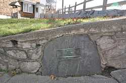
The 1761 Milestone is a milestone on 640 South Main Street in Woonsocket, Rhode Island. The stone originally marked the junction of a Colonial highway from Great Road and an east-west route from Boston, Massachusetts to the state of Connecticut. The stone was rediscovered during the installation of an electrical road (likely a tram). In 1898, the stone was reportedly restored to its original location by the local chapter of the Daughters of the American Revolution. The stone is embedded in a low retaining wall at the corner of South Main Street and Smithfield Road. It was added to the National Register of Historic Places on November 24, 1982 and is historically significant as Colonial-era highway marker.
History
The 1761 Milestone is a historic marker that marked the junction of a Colonial highway. In 1761, it was located at the intersection of Great Road, from Providence, Rhode Island to Mendon, Massachusetts, and an east-west route from Boston, Massachusetts into Connecticut. Currently, the marker rests near the intersection of South Main Street and Smithfield Road (previously Great Road) and occupies the land designated by the Woonsocket Assessor as plat 4-C, lot 69.[2][3]
The 2 feet (0.61 m) by 3 feet (0.91 m) marker is described by the National Register of Historic Places (NRHP) nomination form as an "odd-shaped piece of grey slate, somewhat broken and effaced..."[2] It bears a boldly cut inscription of an unknown stonecutter; the inscription is likened to 18th-century handwriting and lacks a calligraphic pattern.[2] The marker reads "Miles to [B]oston 1761", but according to Rhode Island: A Guide to the Smallest State it read, "Miles to Boston 47".[2][4]
In 1898, it was reported that the stone was unearthed during the installation of electrical road (likely for a tram) and restored to its original location by the Woonsocket chapter of the Daughters of the American Revolution.[5] Sometime later, the Daughters of the American Revolution placed a bronze plaque on the stone, but it was absent at the time of its nomination in 1982.[2] The marker is currently mortared into a retaining wall at the edge of the sidewalk on 640 South Main Street at the intersection and has been since prior to 1982.[2] As of 2013, a Daughters of the American Revolution plaque is present.
Importance
The National Register of Historic Places nomination states the marker is at its original site and is historically important because "[t]his milestone is the only extant Woonsocket property which well recalls this era in the early history of American overland transportation, and it is one of but a handful of such stones surviving in Rhode Island that marks inter-colonial highways."[2] It was added to the National Register of Historic Places on November 24, 1982.[1]
See also
References
- ↑ 1.0 1.1 1.2 "National Register Information System". National Register of Historic Places. National Park Service. 2007-01-23.
- ↑ 2.0 2.1 2.2 2.3 2.4 2.5 2.6 "National Register MRA for Woonsocket, Rhode Island". State of Rhode Island. Retrieved 2013-11-19.
- ↑ Capace, Nancy (May 1, 2001). The Encyclopedia of Rhode Island. St. Clair Shores, Michigan: Somerset Publishers, Inc. p. 368. ISBN 9780403096107. Retrieved August 17, 2014.
- ↑ Federal Writers' Project (1937). Rhode Island: A Guide to the Smallest State. Cambridge, Massachusetts: US History Publishers. p. 380.
- ↑ The American Monthly Magazine 12. Washington, D.C.: R.R. Bowker Company. 1898. p. 437.
External links
- "Milestones". Stones of Northeastern United States. Retrieved August 24, 2014.
| ||||||||||||||||||||||||||