Šiprage
| Šiprage | |
|---|---|
| Village | |
|
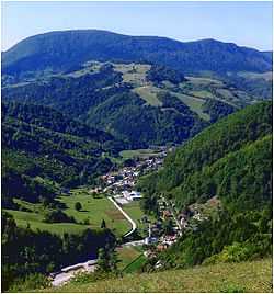
Šiprage – Panorama of the central settlement | |
| Country | Bosnia and Herzegovina |
| Entity | Republika Srpska |
| Municipality | Kotor Varoš |
| Highest elevation | 510 m (1,670 ft) |
| Lowest elevation | 507 m (1,663 ft) |
| Population (Census 1991) | |
| • Total | 952 |
Šiprage is a settlement in the Bosnia and Herzegovina, Entity Republika Srpska, Kotor Varoš Municipality.[1][2][3][4]
Administrative status of this places was changed – from the local community has become is a municipality in the county of Kotor–Varoš, in order to ensure in the 1964th back to the level of local communities.
Name
The modern name is derived from noble–bey family Šipraga.[5] It is unclear whether their ancestors represent autochthonous population or they migrated into the area and acquired spacious property in the valley of the river Vrbanja and its tributaries. According to the oral traditions and cadastre records, their expansion started from Pougarje (slopes of Vlašić Mountain) in the valley of River Ugar.
Geography
Šiprage is on the River Vrbanja river, on its south-eastern upstream line of the Banja Luka (about 60 km) and the Kotor Varoš (30 km) and the Center is part of the local community. Located in the triangle valley between several mountain ranges: the north-east is the Šipraško Brdo (Šiprage's Hills. the tip of the Glavić - Glans, 950 m), south: Jasik (769 m), to the southeast of the complex Šahinovina – Stražbenica (848 m), west: Radohova (top: Kape, 950 m) and the north-west: Borčići (799 m) with Hrastik.[1][2][6] The settlement, along with Vrbanja and its tributaries, is about three long and two kilometers wide. It is rich in sources of drinking water, one of which is (along the Crkvenica) used to supply the local aqueduct network. In the place, in Vrbanja confluence there are flowing: Musić potok (stream), Crkvenica and Bakin potok (Grandmother's Creek), on the right side, but Ćorkovac, Zagradinski potok (Creek) and Demićka on the left riverside.
Nature and ecology
In the Šiprage's Valley and on the surrounding slopes, along with its tributaries,Vrbanja river and stretch the surface of arable land, with heights are belts of mixed deciduous and coniferous forests (spruce and abies, white and black pine) and mixed woods with beech and hornbeam.[7] In these ecosystems and mountain meadows there are big and small game (bear, wild boar, wolf, fox, rabbit, hedgehog, badger, marten and wease, hedgehog, etc.). Pastures, cutters and a catchment area covering the life of the natural community (biocenosis) of the associated vegetation zones. But upstream from the Obodnik village and all the way to Tomina Luka (Tom's field) in its upper flow, the Vrbanja confluence belongs to the salmonid waters. However, et first the grayling, after huchen too, and now brown trout will gradually fade away. Grayling is completely missing in the 1970s, and the survival of trout endanger numerous natural and anthropogenic factors. It is especially extreme flooding during 2000th. There are the irrational fishing and pollution with sludge and secondary by-products of exploitation of forest resources. Picking a fish stock is trying to compensate for the regular stocking of, which in turn leads to the question of local populations gene found, because it autochthonous specifities, even in the source area of the flows of Vrbanja river and its tributaries.
History
Roman Age
According to the contextual sources, the first settlements in the Vrbanja valley in the Neolithic were existed. This area was then inhabited by the Illyrians, and in the 4th century BC. was the first time penetrated Celts. They are more invasion lingering in Bosnia. At the end of Ancient World valleies of Vrbas, Vrbanja river and Sana river inhabited by the Illyrian tribe Maezaei.[8]
After nearly a century of resistance of the natives, in the 1st century this valley was conquered by Romans which gradually suppress the Illyrians and assimilate Maezaei.[9] They recruit them in their army, including the Navy. Then Romans declared the Ilyrics Province (sout-west Balcans).[10][11] From this period there are several sites that indicate the Roman buildings in Siprage at the mouth Crkvenica – in Vrbanja river ("at the field of Omer Bey Šipraga," 1981), discovered the remains of an early Christian Basilica (3rd - 5th century).[12]
Archaeological records confirm the existence of a Roman settlement in this location, while tufa stećci has testified to the Oldbosnian (Bogomils) settlement in the twelfth century.[5][13] The original location of stećci was confluence of rivulet Crkvenica and River Vrbanja (at the very rivers' banks).[5] They were cut out and built in the walls of the surrounding buildings (possibly due to the beliefs of their miraculous properties). One of the best preserved stećak is submerged in River Vrbanja, in the immediate proximity of its primary location.
Middle Ages
In the seventh century this area was populated by South Slavs who were mixing all this with the natives until the present day. The autochthonous population of "Dobri Bošnjani" (Good Bosnians) in Šiprage area were et least in majority. The first Bosnian State was established in 10th Century. According to the Chronicle of the priest of Duklja, half the 12th Šiprage's area is in province of Donji kraji (Down regions), dating back to 1322, 1323 and 1412. Stephen II Kotromanić (the Bosnian ban, 1322 -1353), gives away to Vukosav Hrvatinić (1322) the year of the parish Danica and Vrbanja with Ključ cities and Kotor as a personal possession, because he has this helped you when you download the Government in conflict with the Babunići (from Bosnia also). This feudal possession of Bosnia later, 1404. year even more bloated Hrvoje Vukčić Hrvatinić, who called himself master of the Donji kraji (Lower ends, the area of the river Vrbas to over Sane and later even more provinces).[14] Although the Hungarian Kings Louis I and Sigismund, tried to conquer Bosnia, not miscarriages. Even the Hungarian King Sigismund, and after 1411 year, Hrvoje Vukčić Hrvatinić admitted the right of possession of the Donji kraji province. At that time, the cities of Kotor (including Šiprage) and Zvečaj in Rijesno near Banja Luka had a strategic importance for the defense of the Bosnian State. In the medieval ages, Šiprage belonged to the old state of Bosnia, province of Donji kraji (Lower regions), and after it was occupied by the Ottomans (1519).[15] In 1878 to power come from the Austro-Hungarian Monarchy and remain until the occurrence of the First Yugoslavia.
Ottomans Rule
Vrbanja valley and its administrative center, the medieval town of Kotor, Ottomans invaded 1519, only 56 years after the fall of Bosnia (1463)[16]
Except for the transmission "from generation to generation", there are very few data available on the Ottomans era in the Vrbanja valley. Under its present census names, the settlements of this valley was first mentioned in 1889 years, after the census, which was developed by Austro-Hungarian authority, after the annexation of Bosnia and Herzegovina, 1878 (as agreed by the "great powers")
Austro-Hungarian Rule
The primary intention of the Austro-Hungarian Addministration (1878-1914) by the construction of the narrow-tracks railway line was that, with the mediation of the national Government in BiH, it intensifies the exploitation of forest and other natural resources. The railroad came from Kotor Varoš, and in the area of Šipraga is diverse in several directions. Along the Demićka went to the under Dunići rocks (825 m), and in addition at Crikvenica to Grič (823 m). From The Kruševo Brdo are two-tailed went to stripes: along Vrbanjia and Bobovica upstreams. The route along the Vrbanja is made via the Kilavac to the Čekrk ("winch handles" ) and then – after transport locomotives, using the specias spindle (in the gorge between Šepirice) – up to Riječica (1300 m). Branching with Bobovica was passing through the village of Bobovice, and between Pašinac and Palike to Srebrena brda (Silver Hills; according to Meokrnje mountain), i.e. to the mouth of the stream Krna (921 m).[17]
On trases of deconstructed tracks, they later built the local road for the many Šiprage's villages.
Yugoslavia
After the December 1, 1918, Šiprage are in Kingdom of Serbs, Croats and Slovenians, and Kingdom of Yugoslavia (to 1941).
During 2nd World War, the Šiprage were a powerful stronghold and a sanctuary more partisan units, including 12th Divisian Hospital (in the Gorge of Demićka), serviceing its 5th Corpus. In the area of Šiprage, at the very beginning of the War, there were several local partisan unit forces that were later included in the incoming larger formations. On January 6, 1944, the Germans broke through the partisan defence lines on the Raskršće locality (Crossroads) between the villages of Sopan and Kerle. On January 7, entered the Centre Šiprage, where are the others up to January 15, 1944.
Even though this place was and left out the most important they, the more times it is bombed, with attacks of Germans and Chetniks forces, including the units of Draža Mihailović. Deep river cliffs on the slopes of the Brestovača (between Zlovarići and Dunići villages, i.e. Dunići's rocks[18]) was hardly noticeable for the German aviation. During so called „6th Enemy Offensive“ in Bosnia, former Yougoslavia, the 12th Division's Mobil Hospital were established, for theirs 5th Corpus (1943/1944). This Hospital was in two baracs and few dwelling pits. It was survived to tactics dislocation on other places (January 4, 1944). That was in spite of multiple Luftwaffe's bombing on nearby Šiprage (because unprecious localizing of main target – the Hospital). Precautionary, the Hospital is was dislocated in the surrounding villages and further to Korićani. Then it was about 600 injured and patients moved into the village of Stopan and Lozići, then in Palivuk, Čudnić and Kruševo Brdo. After the passage of the Offensive against, for ten days (at January 15, 1944), it was returning again in Šiprage. Later it turned out that even enemy forces did not have precise information about its location.[19][20][21] After the War, at the 1960th, the skeleton remains from a primary graves in the woods, moved to a common Partisan Memorial Cemetery in Šiprage (locality: Zagradine).[22]
Bosnian War
During the War in Bosnia (1992 – 1995), Serbs Police and Army forces were just devastated surrounding Bosniak's villages, especially those upstream along the Vrbanja to Kruševo Brdo, as well as all Bosniak and Croat villages downstream to Banja Luka.[23][24][25][26][27][28][29][30][30][31][32][33][34][35][36][37][38][39][40] The local population is the civilian population were killed or the displaced. After 1996, most of the Šiprage's Bosniak villages was partly restored, thanks to the Government and the soldiers of Luxembourg, i.e. Battalion BELUGA (abbreviation from: Belgium – Luxembourg – Greece – Austria), within the SFOR-EUFOR Mission.[29][41][42][43][44][45] Only mosque in wide area is renewed. During the War in the Centre of the village the Eastern Orthodox Church was built (on the site of the former "Forestry House" and a former Seat of the local administration).
Population
| Šiprage[46][47] | ||||||
| background-color:#F5DEB3;"| Census Year | background-color:#C2B280;"| 1991. | background-color:#C2B280;"| 1981. | background-color:#C2B280;"| 1971. | |||
| Bosniaks | 745 (78.25%) | 711 (60.10%) | 422 (51.33%) | |||
| Serbs | 168 (17.64%) | 320 (27.04%) | 370 (45.01%) | |||
| Croats | 1 (0.10%) | 6 (0.50%) | 0 | |||
| Yugoslavians | 32 (3.36%) | 136 (11.49%) | 21 (2.55%) | |||
| Other and Unknown | 6 (0.63%) | 10 (0.84%) | 9 (1.09%) | |||
| style="background:style=;"background-color:#F5DEB3;"|Total | 952 | 1,183 | 822 | |||
See also
- Vrbanja river
- Ćorkovac
- Crkvenica
- Demićka
- Kotor Varoš
References
- ↑ 1.0 1.1 Vojnogeografski institut, Ed. (1955): Travnik (List karte 1:100.000, Izohipse na 20 m). Vojnogeografski institut, Beograd.
- ↑ 2.0 2.1 Spahić M. et al. (2000): Bosna i Hercegovina (1:250.000). Izdavačko preduzeće „Sejtarija“, Sarajevo.
- ↑ Mučibabić B., Ed. (1998): Geografski atlas Bosne i Hercegovine. Geodetski zavod BiH, Sarajevo, ISBN 9958-766-00-0.
- ↑ http://www.maplandia.com/bosnia-and-herzegovina/federacija-bosne-i-hercegovine/vlasic/
- ↑ 5.0 5.1 5.2 Radimsky V. (1892): Ostanci rimskih naseobina u Šipragi i Podbrgju, za tim starobosanski stećci u Šipragi i uz Vrbanju u Bosni. Glasnik Zemaljskog muzeja u Sarajevu, Godina IV, Knjiga I: 75–80.
- ↑
- ↑
- ↑ Malcolm N. (1996): Bosnia: A Short History. New, Updating Edition, New York University Press, ISBN 0.814.755.615.
- ↑ Idrizović M., Ed. (1987): Umjetničko blago Bosne i Hercegovine. Svjetlost, Sarajevo, ISBN 86-01-01121-7
- ↑ Enciklopedija Jugoslavije, Ed. (1983): Socijalistička Republika Bosna i Hercegovina – Separat iz II izdanja Enciklopedije Jugoslavije. Jugoslavenski leksikografski zavod, Zagreb.
- ↑ Imamović M. (1997): Historija Bošnjaka. „Preporod“, Sarajevo, UDK 949.715-323.1(=864).
- ↑ Radimsky V. (1892): Ostanci rimskih naseobina u Šipragi i Podbrgju, za tim starobosanski stećci u Šipragi i uz Vrbanju u Bosni. Glasnik Zemaljskog muzeja u Sarajevu, Godina IV, Knjiga I: 75-80.
- ↑ Richter E. (1905): II. Historička i politička geografija. Glasnik Zemaljskog muzeja u Sarajevu, Godina XVI, Knjiga 1: 275–321.
- ↑ https://bs.wikipedia.org/w/index.php?title=Hvalov_zbornik&stable=0&shownotice=1
- ↑ Malcolm N. (1996): Bosnia: A Short History. New, Updating Edition, New York University Press, ISBN 0814755615.
- ↑ Imamović M. (1997): Historija Bošnjaka. "Preporod", Sarajevo, UDC 949.715-323.1 (= 864).
- ↑ Vojnogeografski Institut, Ed. (1955): Travnik (List karte 1: 100,000, izohipse na m). Vojnogeografski institut, Beograd.
- ↑
- ↑ Petrić N., Ed. (1985): Opštine Kotor-Varoš i Skender-Vakuf u NOB-u 1941-1945. Radnički univerzitet „Đuro Pucar Stari“, Kotor Varoš.
- ↑ Đondović R., Ed. (1989): Sanitetska služba u narodnooslobodilačkom ratu Jugoslavije 1941-1945, Knj. 2: Nastanak i razvoj sanitetske službe u oružanim snagama narodnooslobodilačkog pokreta u Bosni i Hercegovini, Crnoj Gori, Hrvatskoj i Makedoniji; Biblioteka Ratna prošlost naroda i narodnosti Jugoslavije, knj. 361. Monografija Jedinica NOV i PO Jugoslavije, Knj. 150). Vojnoizdavački i novinski centar, Sanitetska uprava SSNO, Beograd.
- ↑ Samardžija S. (1983): Četrnaesta srednjobosanska NOU brigada. Skupština opštine Prnjavor, Banja Luka.
- ↑ http://www.udaljenosti.com/bosna/
- ↑ Gutman R. (1993): A witness to genocide: The 1993 Pulitzer Prize-Winning Dispatches on the "Ethnic Cleansing" of Bosnia. Macmillan Publishing Company, Inc., New York, ISBN 9780020329954.
- ↑ Beč J. (1997): Pucanje duše. Samizdat B92, Beograd, ISBN 86-7208-010-6.
- ↑
- ↑
- ↑
- ↑
- ↑ 29.0 29.1
- ↑ 30.0 30.1
- ↑ Fena, Agencija (2013): Obilježavanje 21. godišnjice stradanja Bošnjaka u Kotor-Varoši – Još se traži 277 osoba. Avaz, 03. 11. 2013.
- ↑
- ↑
- ↑
- ↑
- ↑
- ↑
- ↑
- ↑
- ↑ http //www.search-document.com/
- ↑
- ↑
- ↑
- ↑
- ↑
- ↑ Book: "Nacionalni sastav stanovništva – Rezultati za Republiku po opštinama i naseljenim mjestima 1991.", statistički bilten br. 234, Izdanje Državnog zavoda za statistiku Republike Bosne i Hercegovine, Sarajevo.
- ↑ internet – izvor, "Popis po mjesnim zajednicama" – http://www.fzs.ba/Podaci/nacion%20po%20mjesnim.pdf