Šar Mountains
| Šar Mountains | |
|---|---|
| Sharr Mountains | |
|
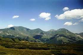
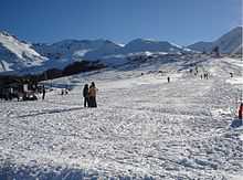
Šar Mountains as seen from Macedonia | |
| Highest point | |
| Peak | Titov Vrv (Macedonia) |
| Elevation | 2,748 m (9,016 ft) |
| Geography | |
| Location |
Macedonia-Polog Valley Albania-Dibër County Kosovo[a] |
The Šar Mountains (Macedonian and Serbian: Шар планина/Šar planina) or Sharr Mountains (Albanian: Malet e Sharrit), is a mountain range in the Balkans that extends from Kosovo[a] and the northwest of the Republic of Macedonia, to northeastern Albania.
Etymology
In Antiquity, the mountains were known as Scardus, Scodrus, or Scordus (το Σκάρδον ὂρος in Polybius and Ptolemy);.[1] The modern names come from the ancient ones.
Sometimes the range is called Carska planina ("Tsar's mountain"), as a reference to the capitals (Prizren and Skopje), courts (Nerodimlje, Pauni, Svrčin, etc.) and monasteries (Monastery of the Holy Archangels) of the Serbian Empire located in the region.[2]
Borders
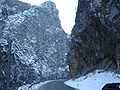
The mountain borders extend from the city of Prizren, following the two rivers of the Prizren Lumbardhi and the Lepenac. In the east it passes by the town of Kaçanik through the Kačanik Gorge and into Macedonia via the Polog valley. The border passes near the Vardar spring called Vrutok and enters near the valley of Mavrovo. There the Radika river separates the mountain massif from the higher Mount Korab. After that, the border is mounting, reaching the point of junction of three state borders: Kosovo, Macedonia and Albania. The border now follows the road to the small, mountainous, town of Restelica, the rivers of Globocica, Plava and the White Drin and finally reaches the city of Prizren.
Geographical characteristics
The Šar Mountains have a total area of 1600 km. 56,25% of that area is in the Republic of Macedonia, 43.12% in Kosovo, and 0,63% in Albania.[3] There are three plains Sirinic, Vraca and Rudoka.[4] The system is about 80 km (50 mi) long and 10–20 km (6–12 mi) wide.
The mountain massif has been formed in the Tertiary Period. The most upper parts of the mountains have been frozen with large amounts of ice and snow.
It includes several high peaks:
- Titov Vrv (2,747 m or 9,012 ft)
- Mal Turčin (2,707 m or 8,881 ft)
- Bakardan (2,704 m or 8,871 ft)
- Borislavec (2,675 m or 8,776 ft)
- Great Rudoka (2,658 m or 8,720 ft)
- Bistra - east summit (Peskovi) (2,651 m or 8,698 ft)
- Bistra - west summit (2,641 m or 8,665 ft)
- Small Rudoka (2,629 m or 8,625 ft)
- Džini Beg (2,610 m or 8,563 ft)
- Lake Peak (2,604 m or 8,543 ft)
- Karabunar (2,600 m or 8,530 ft)
- White Lake Peak (2,590 m or 8,497 ft)
- Maja e zezë (2,585 m or 8,481 ft)
- Big Vraca (2,582 m or 8,471 ft)
- Guzhbaba (2,582 m or 8,471 ft)
- Isa Aga (2,555 m or 8,383 ft)
- Black Peak (2,536 m or 8,320 ft)
- Kobilica (2,528 m or 8,294 ft)
- Piribeg (2,524 m or 8,281 ft)
- Ljuboten (2,498 m or 8,196 ft)
- Maja Livadh (2,497 m or 8,192 ft)
- Zallina (2,493 m (8,179 ft))
- Small Vraca (2,483 m or 8,146 ft) 41°53′10″N 20°44′15″E / 41.8861111°N 20.7375°E
- Kara Nikolla (2,409 m or 7,904 ft) 42°05′01″N 20°47′39″E / 42.0836111°N 20.7941667°E
- Tumba Peak (2,346 m or 7,697 ft)
- Gemitash (2,183 m or 7,162 ft) 41°54′27″N 20°40′51″E / 41.9075°N 20.6808333°E
- Kalabak (2,174 m or 7,133 ft) 41°55′05″N 20°34′34″E / 41.918°N 20.576°E[5]
- Crnkamenska Kula (2,117 m or 6,946 ft) 41°54′02″N 20°39′50″E / 41.900556°N 20.663889°E
- Šerupa (2,092 m or 6,864 ft) tri-point 41°52′37″N 20°35′42″E / 41.877°N 20.595°E
The Šar Mountains extend to Mount Korab (2,764 m or 9,068 ft) in the southwest, and pass into northeastern Albania with very small part (0.63% of the entire length).
Vegetation on the mountains includes crops up to around 1,000 m (3,281 ft), forests up to 1,700 m (5,577 ft), and above that lie high pastures which encompass around 550 km2 (212 sq mi). The Šar Mountains are the largest compact area covered with pastures on the European continent. They are most known as the origin of the dog breed Šarplaninac, which was bred on these pastures.
The snowy peaks of the Šar Mountains are depicted on the coat of arms of the city of Skopje, which in turn is incorporated in the city's flag.[6]
Šar Mountains in Kosovo
The Šar Mountains are located in the south and south-east of Kosovo, where 43.12% of the range is located. Many alpine and glacial mountain lakes are found on the Kosovar part of the Šar Mountains, especially south of the village of Dragaš, the area of Shutman and the region north of Vraca. The ski resort of Brezovica, with an elevation of 900 m (2,953 ft) to 2,524 m (8,281 ft) above sea level, is located north-east of the mountains.
The mountain range in Kosovo is divided into three main zones:The zone of Ljuboten and Brezovica, the central zone of Prizren and the zone of Opoja and Gora.
The mountains border the Kosovo Plain to the north-east and the Dukagjini Valley in the north- west. Kosovo consists of the most eastern tip and the most northern part of the Mountain ridge. The Ljuboten peak and the mountain of Skopska Crna Gora create the Kačanik Gorge in Kosovo. The Šar Mountains are split from the Nerodimka Mountain by the Sirinić Valley. The Šar National Park is located in Kosovo. Villages and towns that are found near the mountain are:
Lakes in the Kosovo part of the Šar Mountains are:
- Big Jažinačko Lake
- Small Jažinačko Lake
- Šutmansko Lake
- Lower Defsko Lake
- Štrbačko Lake
- Black Vir Lake
- Donji Vir Lake
- Blateško Lake
- Upper Defsko Lake
- Dinivodno Lake
National Park
| Šar Mountains National Park | |
|---|---|
|
IUCN category II (national park) | |
|
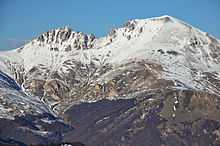
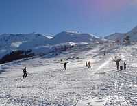
Šar Mountains National Park landscape. | |
| Area | 390 km² |
| Established | 1986 |

The Šar Mountains National Park is in the territory of Kosovo and spreads on 390 km2 (151 sq mi), on the northern slopes of the Šar Mountains as well as the mountains of Ošljak and Jezerce mountains. The National Park “Šar-Planina Mt.” was proclaimed in 1993 within the temporary boundaries of 39,000 ha and began activity in 1995.[7] It is planned that the definite boundaries of the Park would enclose an area of around 97,000 ha. What this national park boasts in particular are the endemic relict Macedonian Pine and white-bark pine, as well as the Alpine rose. As for wildlife, this is the habitat of the lynx, bear, chamois, wolf, roe deer, wild boar and other species including this areas richness in bird species. The national park contains 720 chamois while the Opoja and Gora region contains 600 chamois.
Gallery
See also
| Wikimedia Commons has media related to Šar Mountain. |
- Mountains of the Republic of Macedonia
- List of mountains in Kosovo
- List of mountains in Albania
- List of mountains in Serbia
Notes
| a. | ^ Kosovo is the subject of a territorial dispute between the Republic of Serbia and the Republic of Kosovo. The latter declared independence on 17 February 2008, but Serbia continues to claim it as part of its own sovereign territory. Kosovo's independence has been recognised by 108 out of 193 United Nations member states. |
References
- ↑ William Smith, Dictionary of Greek and Roman geography p. 928
- ↑ Veselinović, Andrija; Radoš Ljušić (2001). Srpske dinastije (in Serbian). Novi Sad. ISBN 86-83639-01-0.
- ↑ Rista Nikolić (1912). Glacijacija Šar Planine i Koraba (in Serbian). Beograd.
- ↑ Živko Stefanovski. Šar Planina (in Macedonian). Tetovo: Napredok.
- ↑ http://www.brezovica-ski.com/en/national-park
- ↑ Official portal of the city of Skopje: City symbols. – Retrieved on 13 May 2009.
- ↑ Ministry of Environment and Spatial Planning(in Albanian)
External links
- Nacionalni park Šar-planina (in Serbian)
- Šar planina (in Serbian)
- Brezovica Ski Resort
| |||||||||||||||||||||||||||||||||||||||||||||||||||||||||||
| |||||||||||||||||||||||||||||||||||||||||
| ||||||||||||||||||