Świecie
| Świecie Świecie nad Wisłą | |||
|---|---|---|---|
|
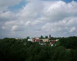
Town view from the Teutonic castle tower | |||
| |||
|
Motto: Świecie - najlepsze na świecie Świecie - the best in the world | |||
 Świecie | |||
| Coordinates: 53°25′N 18°26′E / 53.417°N 18.433°ECoordinates: 53°25′N 18°26′E / 53.417°N 18.433°E | |||
| Country |
| ||
| Voivodeship | Kuyavian-Pomeranian | ||
| County | Świecie County | ||
| Gmina | Gmina Świecie | ||
| Established | 1198 | ||
| Town rights | 1338 | ||
| Government | |||
| • Mayor | Tadeusz Grzegorz Pogoda | ||
| Area | |||
| • Total | 11.87 km2 (4.58 sq mi) | ||
| Highest elevation | 86 m (282 ft) | ||
| Lowest elevation | 19 m (62 ft) | ||
| Population (2006) | |||
| • Total | 25,614 | ||
| • Density | 2,200/km2 (5,600/sq mi) | ||
| Time zone | CET (UTC+1) | ||
| • Summer (DST) | CEST (UTC+2) | ||
| Postal code | 86-100 to 86-105 | ||
| Area code(s) | +48 52 | ||
| Car plates | CSW | ||
| Website |
www | ||


Świecie [ˈɕfjɛt͡ɕɛ] (German: Schwetz) is a town in northern Poland with 25,968 inhabitants (2006), situated in Kuyavian-Pomeranian Voivodeship (since 1999); it was previously in Bydgoszcz Voivodeship (1975-1998). It is the capital of Świecie County.
Geographical location
Świecie is located on the west bank of river Vistula at the mouth of river Wda, approximately 40 kilometers north-east of Bydgoszcz, 105 kilometers south of Gdańsk and 190 kilometers south-west of Kaliningrad.

History
In Świecie was, when in 1198 St. Mary's church was opened here, the residence of the Pomeranian Duke Grimislaw. His sphere of control included also the towns of Starogard Gdański and Lubiszewo Tczewskie as well as the region around Skarszewy. In 1310, when the Teutonic Order bought Pomeralia from the Margraves of Brandenburg, the settlement had already the status of a Civitas, just as Gdańsk and Tczew did. When it was granted Kulm law by the Teutonic Order, it was still located on the high west bank of the Vistula. Probably because of destruction by fire, during the time period 1338–75 it was translocated down into the valley at the Vistula. After the Thirteen Years' War (1454–66) the town became part of the autonomous province of Royal Prussia incorporated into the Kingdom of Poland. In 1772 the town was annexed by the Kingdom of Prussia, and Schwetz was integrated into the newly formed Province of West Prussia. In 1905 the town had a Protestant church, two Catholic churches and a synagogue.[1] After World War I Świecie became part of the Second Republic of Poland.
During the Second World War, Nazi Germany occupied Świecie and annexed it, making it the seat of the county/district (Kreis) of Schwetz. It was administered as part of Reichsgau Danzig-West Prussia. After World War II it was put under the administration of the People's Republic of Poland.
Number of inhabitants by year
| Year | Number |
|---|---|
| 1788 | 1,780 |
| 1831 | 2,660 |
| 1837 | approx. 3,000 |
| 1875 | 5,210 |
| 1880 | 5,946 |
| 1890 | 6,716 |
| 1905 | 7,747 |
| 1931 | 8,730 |
| 1943 | 11,664 |
| 2008 | 25,614 |
Note that the above table is based on primary, potentially biased, sources.[2][3][4][5][5]
Notable residents
- Günther Radusch (1912-1988), Luftwaffe pilot
- Heinrich von Plauen (the Elder) (ca. 1370–1429), 27th grand master of the Teutonic Order.
- Aleksy Kuziemski
Major corporations
- Mondi Świecie SA (before Mondi Packaging Paper Świecie SA and Frantschach Świecie SA and Celuloza Świecie SA) (paper and packaging)
Education
- Wyższa Szkoła Menedżerska
- I LO im. Floriana Ceynowy
- II LO w Świeciu
- Zespół Szkół Ponadgimnazjalnych
Sport
Footnotes
- ↑ Meyers Konversations-Lexikon, 6th edition, Vol. 18, Leipzig and Vienne 1909, p. 210.
- ↑ Johann Friedrich Goldbeck: Vollständige Topographie des Königreichs Preußen. Teil II, Marienwerder 1789, p. 72, no 3.
- ↑ August Eduard Preuß: Preußische Landes- und Volkskunde. Königsberg 1835, p. 386.
- ↑ Friedrich Christoph Förster: Statistisch-topographisch-historische Uebersicht des Preußischen Staats, Berlin and Leipzig 1838, p. 96.
- ↑ 5.0 5.1 Michael Rademacher: Deutsche Verwaltungsgeschichte Provinz Westpreußen, Kreis Schwetz (2006).
| Wikimedia Commons has media related to Świecie. |
| |||||||||||||||||
| ||||||||||