Þingvallavatn
| Þingvallavatn | |
|---|---|
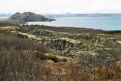 Fissures at the lake | |
| Location | Þingvellir National Park |
| Coordinates | 64°11′N 21°09′W / 64.183°N 21.150°WCoordinates: 64°11′N 21°09′W / 64.183°N 21.150°W |
| Primary outflows | Sog |
| Basin countries | Iceland |
| Surface area | 84 km2 (32 sq mi)[1] |
| Average depth | 34 m (112 ft)[1] |
| Max. depth | 114 m (374 ft)[1] |
| Water volume | 2.856 km3 (0.685 cu mi)[1] |
| Residence time | 11 months[2] |
| Islands | Sandey |
Þingvallavatn is a rift valley lake in southwestern Iceland. With a surface of 84 km² it is the largest natural lake in Iceland. Its greatest depth is at 114 m. At the northern shore of the lake, at Þingvellir (after which the lake is named), the Alþingi, the national parliament, was founded in the year 930.
The lake lies partially within Þingvellir National Park. The volcanic origin of the islands in the lake is clearly visible. The cracks and faults around it, of which the famous Almannagjá canyon is the largest, is where the Eurasian and North American tectonic plates meet. Silfra fissure is a popular scuba and snorkeling site. The only outflow from lake Þingvallavatn is the Sog River.
One of the noted features of the lake is the presence of four morphs of the Arctic charr.[3]
See also
- List of lakes of Iceland
- Volcanism in Iceland
- Geography of Iceland
References
- ↑ 1.0 1.1 1.2 1.3 http://visindavefur.hi.is/svar.php?id=4236
- ↑ http://www.vedur.is/um-vi/saga/molar/nr/2021
- ↑ Malmquist, H. J., Snorrason, S. S., Skulason, S., Jonsson, B., Sandlund, O. T., & Jonasson, P. M. (1992). Diet differentiation in polymorphic Arctic charr in Thingvallavatn, Iceland. Journal of Animal Ecology, 21-35.
External links
| ||||||||