Ørland
| Ørland kommune | |||
|---|---|---|---|
| Municipality | |||
 | |||
| |||
 Ørland within Sør-Trøndelag | |||
| Coordinates: 63°42′32″N 9°36′38″E / 63.70889°N 9.61056°ECoordinates: 63°42′32″N 9°36′38″E / 63.70889°N 9.61056°E | |||
| Country | Norway | ||
| County | Sør-Trøndelag | ||
| District | Fosen | ||
| Administrative centre | Brekstad | ||
| Government | |||
| • Mayor (2003) | Hallgeir Grøntvedt (Sp) | ||
| Area | |||
| • Total | 73.56 km2 (28.40 sq mi) | ||
| • Land | 73.43 km2 (28.35 sq mi) | ||
| • Water | 0.08 km2 (0.03 sq mi) | ||
| Area rank | 401 in Norway | ||
| Population (2010) | |||
| • Total | 5,121 | ||
| • Rank | 189 in Norway | ||
| • Density | 69.7/km2 (181/sq mi) | ||
| • Change (10 years) | 1.7 % | ||
| Demonym | Ørlending[1] | ||
| Time zone | CET (UTC+1) | ||
| • Summer (DST) | CEST (UTC+2) | ||
| ISO 3166 code | NO-1621 | ||
| Official language form | Bokmål | ||
| Website |
www | ||
|
| |||


Ørland is a municipality in Sør-Trøndelag county, Norway. It is part of the Fosen region. The administrative centre of the municipality is the town of Brekstad. Other villages include Uthaug, Opphaug, and Ottersbo. Brekstad declared itself to be a town in 2005.
Ørland is located at the southwestern tip of the Fosen peninsula at the northern shore of the mouth of Trondheimsfjord where the Stjørnfjord arm begins.
General information
The municipality of Ørland was established on 1 January 1838 (see formannskapsdistrikt). In 1853, the northern district of Bjugn was separated to become a municipality of its own. This left Ørland with 3,361 residents. On 1 January 1896, the southern district of Værnes was separated from Ørland to become the municipality of Agdenes. After the division, Ørland had 3,649 residents.[2]
Name
The Old Norse form of the name was Yrjar. This is a plural form derived from aurr which means "gravel". The last element land was added in the 16th century (spelled "Ørieland" in 1590).[3]
Coat-of-arms
The coat-of-arms is from modern times. They were granted on 9 February 1979. The arms are derived from the arms of Inger, Lady of Austraat, a noblewoman who lived in Austrått manor, Ørland from 1488–1555 and who played a major role in the history of the area. She was later portrayed by Henrik Ibsen in his play Lady Inger of Ostrat.[4]
Churches
The Church of Norway has one parish (sokn) within the municipality of Ørland. It is part of the Deanery (prosti) of Fosen and the Diocese of Nidaros.
| Parish (Sokn) | Church Name | Year Built | Location of the Church |
|---|---|---|---|
| Ørland | Ørland kirke | 1342 | Brekstad |
| Storfosna kirke | 1915 | Storfosna |
Geography
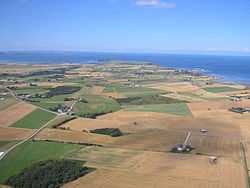
Ørland is largely flat lowland, and rather windy as it faces the Norwegian Sea to the west with the Trondheimsfjord and the mouth of the Stjørnfjord to the east. The majority of the municipality is on the Fosen peninsula, but the islands of Garten, Storfosna, and Kråkvåg are also populated. The Kjeungskjær lighthouse lies at the mouth of the Bjugnfjorden in the northeastern part of the municipality.
Climate
The mean annual temperature is 5.8 °C (42.4 °F) and mean annual precipitation is 1,048 millimetres (41.3 in).[5]
| Ørland | ||||||||||||||||||||||||||||||||||||||||||||||||||||||||||||
|---|---|---|---|---|---|---|---|---|---|---|---|---|---|---|---|---|---|---|---|---|---|---|---|---|---|---|---|---|---|---|---|---|---|---|---|---|---|---|---|---|---|---|---|---|---|---|---|---|---|---|---|---|---|---|---|---|---|---|---|---|
| Climate chart (explanation) | ||||||||||||||||||||||||||||||||||||||||||||||||||||||||||||
| ||||||||||||||||||||||||||||||||||||||||||||||||||||||||||||
| ||||||||||||||||||||||||||||||||||||||||||||||||||||||||||||
Economy
Major occupations are the Ørland Main Air Station, part of the Royal Norwegian Air Force; agriculture; public services; and commerce. Large industries include the Grøntvedt Pelagic herring factory and the Mascot Høie bedclothes factory.
Attractions
Major attractions are the Ramsar Convention Bird Protection areas, the coastal areas themselves, and the Manor of Austrått, dated 1656 and with a known history from around 1000 AD. Other attractions are the single, large Sessile oak (the northernmost in the world, known as Austråtteika) in the nearby forest;[6] and the fortifications of the triple 28-centimetre (11 in) gun turret from World War II, which is now open to public viewing.
Media gallery
-

Austrått Fort, gun turret was taken from the German battleship Gneisenau.
-

Kjeungskjær lighthouse, which can be rented
-

Part of the Manor of Austrått (Austråttborgen).
-
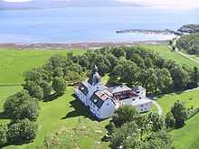
Manor of Austrått and Trondheimsfjord.
References
- ↑ "Personnemningar til stadnamn i Noreg" (in Norwegian). Språkrådet.
- ↑ Jukvam, Dag (1999). "Historisk oversikt over endringer i kommune- og fylkesinndelingen" (in Norwegian). Statistisk sentralbyrå.
- ↑ Rygh, Oluf (1901). Norske gaardnavne: Søndre Trondhjems amt (in Norwegian) (14 ed.). Kristiania, Norge: W. C. Fabritius & sønners bogtrikkeri. p. 49.
- ↑ Norske Kommunevåpen (1990). "Nye kommunevåbener i Norden". Retrieved 28 October 2008.
- ↑ "Ørland: 1961-1990 base period". met.no.
- ↑ "Austråttlunden" (PDF) (in Norwegian).
External links
| Wikimedia Commons has media related to Ørland. |
 Sør-Trøndelag travel guide from Wikivoyage
- Municipal fact sheet from Statistics Norway