Île aux Cochons
| Nickname: Pig Island | |
|---|---|
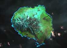
 Satellite image of the island | |
| Geography | |
| Location | South Indian Ocean |
| Coordinates | 46°06′S 50°14′E / 46.100°S 50.233°E |
| Archipelago | Crozet Islands |
| Area | 67 km2 (26 sq mi) |
| Length | 10 km (6 mi) |
| Width | 9 km (5.6 mi) |
| Highest elevation | 770 m (2,530 ft) |
| Highest point | Mont Richard-Foy |
| Country | |
| Demographics | |
| Population | 0 |
Île aux Cochons, or Pig Island, is an uninhabited island in the subantarctic Crozet Archipelago. With an area of 67 km2 (26 sq mi) it is the third largest island of the group. Administratively, it is part of the French Southern and Antarctic Lands.
Description
Île aux Cochons is the westernmost island of the archipelago, lying some 30 km north-west of Île des Pingouins and 15 km south-west of the Îlots des Apôtres. It is an eroded volcanic dome, scattered with inactive craters, and a coastline consisting partly of low cliffs. Introduced species include cats, rabbits and mice. The introduced pigs that gave the island its name have been eradicated. There is no human infrastructure and visits by researchers are rare.[1]
Important Bird Area
The island has been identified as an Important Bird Area (IBA) by BirdLife International as a breeding site for seabirds, and notably for its large penguin populations. It holds the world’s largest king penguin colony, with about half a million breeding pairs, as well as substantial numbers of gentoo, macaroni and northern rockhopper penguins. It also has the largest colony of wandering albatrosses in the Indian Ocean, with some 1200 pairs, as well as four million pairs of medium-billed prions and a million pairs of South Georgia diving petrels. Eaton's pintails are present. There are large populations of southern elephant seals, Antarctic fur seals and subantarctic fur seals.[1]
See also
- List of Antarctic islands north of 60° S
References
- ↑ 1.0 1.1 BirdLife International. (2012). Important Bird Areas factsheet: Île aux Cochons. Downloaded from http://www.birdlife.org on 2012-01-09.
| ||||||||||||||||||
Coordinates: 46°06′S 50°14′E / 46.100°S 50.233°E