Ébreuil
| Ébreuil | ||
|---|---|---|
|
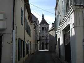
The tower of the church in Ébreuil | ||
| ||
 Ébreuil | ||
|
Location within Auvergne region  Ébreuil | ||
| Coordinates: 46°06′59″N 3°05′15″E / 46.1164°N 3.0875°ECoordinates: 46°06′59″N 3°05′15″E / 46.1164°N 3.0875°E | ||
| Country | France | |
| Region | Auvergne | |
| Department | Allier | |
| Arrondissement | Montluçon | |
| Canton | Ébreuil | |
| Intercommunality | Sioule, Colettes et Bouble | |
| Government | ||
| • Mayor (2008–2014) | Didier Duboisset | |
| Area1 | 23.22 km2 (8.97 sq mi) | |
| Population (2008)2 | 1,270 | |
| • Density | 55/km2 (140/sq mi) | |
| INSEE/Postal code | 03107 / 03450 | |
| Elevation |
301–545 m (988–1,788 ft) (avg. 317 m or 1,040 ft) | |
|
1 French Land Register data, which excludes lakes, ponds, glaciers > 1 km² (0.386 sq mi or 247 acres) and river estuaries. 2 Population without double counting: residents of multiple communes (e.g., students and military personnel) only counted once. | ||

Ébreuil is a commune in the Allier department in central France.
Population
| Historical population | ||
|---|---|---|
| Year | Pop. | ±% |
| 1882 | 2,371 | — |
| 1962 | 1,333 | −43.8% |
| 1968 | 1,347 | +1.1% |
| 1975 | 1,311 | −2.7% |
| 1982 | 1,222 | −6.8% |
| 1990 | 1,148 | −6.1% |
| 1999 | 1,230 | +7.1% |
| 2008 | 1,270 | +3.3% |
See also
References
| Wikimedia Commons has media related to Ébreuil. |