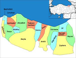
Çaykara
| Çaykara | |
|---|---|
 Çaykara | |
| Coordinates: 40°44′51″N 40°14′31″E / 40.74750°N 40.24194°ECoordinates: 40°44′51″N 40°14′31″E / 40.74750°N 40.24194°E | |
| Country | Turkey |
| Province | Trabzon |
| Government | |
| • Mayor | Hanefi Tok (AKP) |
| Area[1] | |
| • District | 573.14 km2 (221.29 sq mi) |
| Population (2012)[2] | |
| • Urban | 2,000 |
| • District | 13,220 |
| • District density | 23/km2 (60/sq mi) |
| Climate | Cfa |
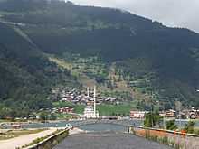
Çaykara is a town and district of Trabzon Province in the Black Sea region of Turkey. As of 2014, the District Mayor of Çaykara is Hanefi Tok (AKP). Çaykara lies in a V-shaped valley along the Solaklı River in the Pontic Mountains, at an elevation of around 300 metres.
Etymology
The district takes its name from the Çaykara stream, which forms through the conjunction of the Solaklı and Yeşilalan brooks. The historic name of Çaykara, when it was still a village, was Kadahor (meaning "lower town" in Pontic Greek).[3] As is typical in transhumance communities in the Pontic Mountains and the Caucasus, Kadahor was settled with a number of subordinate upland villages for different seasons, which explains its name.
History
Çaykara entered Ottoman rule in 1461, following the Ottoman conquest of the Empire of Trebizond by Sultan Mehmed II.
According to the Ottoman tax books (tahrir defterleri) of 1486, there were 1277 people living in the historic villages that were located within the present-day Çaykara district (namely the villages of Ğorğoras (in Greek: Γοργορά), Holayisa, Paçan and Zeno (in Greek: Ξένος), where there were 235 houses (1 of them inhabited by Muslims, 234 of them by Christians.)[4]
According to the Ottoman tax books (tahrir defterleri) of 1681, the inhabitants of the villages of Ğorğoras, Holayisa, Paçan, Zeno, Yente, Haldizen, İpsil (in Greek: Υψηλή), Okene, Sero (Siros), Kadahor, Hopşera, Sarahos (in Greek: Σαχάρω), Fotinos (in Greek: Φωτεινός) and Zeleka had been fully converted to Islam.[4] In 1681, there were 2100 people living in 380 houses, all of them Muslims.[4]
The Sultan Murat Plateau (Turkish: Sultan Murat Yaylası 40°40′12″N 40°10′13″E / 40.67000°N 40.17028°E) is a high plateau 25 km (16 mi) southwest of Çaykara's town center. In 1915, during the Caucasus Campaign of World War I, the Ottoman Army fought the invading Russian troops at this plateau. A monumental cemetery for the fallen Ottoman soldiers, named Şehitler Tepesi (Hill of Martyrs) is located there.
Until 1925, Çaykara was a village bound to the Of district within Trabzon Province. In 1925, it became a bucak (subdistrict), and on 1 June 1947 it became an ilçe (district) of Trabzon Province.
Notable residents
- Cevdet Sunay (1899), Fifth president of Turkey
- Behram Kurşunoğlu (1922), physicist
- Orhan Tekeoğlu (1957), film director
- Yeşim Ustaoğlu (1960), architect and film director
See also
References
- ↑ "Area of regions (including lakes), km²". Regional Statistics Database. Turkish Statistical Institute. 2002. Retrieved 2013-03-05.
- ↑ "Population of province/district centers and towns/villages by districts - 2012". Address Based Population Registration System (ABPRS) Database. Turkish Statistical Institute. Retrieved 2013-02-27.
- ↑ Karadeniz Ansiklopedik Sözlük: "Kadahor", by Özkan Öztürk. Istanbul, 2005.
- ↑ 4.0 4.1 4.2 History of Çaykara
External links
- Çaykara district governor's official website (Turkish)
- Uzungöl Website
- Images of the Sultan Murat Plateau