Çavdarhisar
| Çavdarhisar | |
|---|---|
| Town | |
|
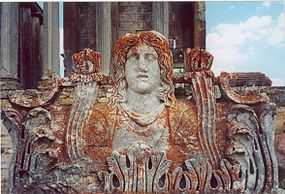
Aizanoi ruins in Çavdarhisar | |
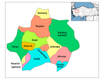 Location of Çavdarhisar within Turkey. | |
 Çavdarhisar Location of Çavdarhisar | |
| Coordinates: 39°12′N 29°37′E / 39.200°N 29.617°E | |
| Country |
|
| Region | Aegean |
| Province | Kütahya |
| Area[1] | |
| • District | 200.07 km2 (77.25 sq mi) |
| Elevation | 1,017 m (3,337 ft) |
| Population (2012)[2] | |
| • Urban | 2,338 |
| • District | 7,786 |
| • District density | 39/km2 (100/sq mi) |
| Time zone | EET (UTC+2) |
| • Summer (DST) | EEST (UTC+3) |
| Postal code | 43xxx |
| Licence plate | 43 |
| Website | www.cavdarhisar.bel.tr |
Çavdarhisar is a town and district of Kütahya Province in the Aegean region of Turkey. According to 2000 census, population of the district is 13,538 of which 4,687 live in the town of Çavdarhisar.[3] The local Kocaçay stream is still crossed by the Roman Penkalas Bridge.
Places of interest
Notes
- ↑ "Area of regions (including lakes), km²". Regional Statistics Database. Turkish Statistical Institute. 2002. Retrieved 2013-03-05.
- ↑ "Population of province/district centers and towns/villages by districts - 2012". Address Based Population Registration System (ABPRS) Database. Turkish Statistical Institute. Retrieved 2013-02-27.
- ↑ Turkish Statistical Institute. "Census 2000, Key statistics for urban areas of Turkey" (XLS) (in Turkish). Retrieved 2008-10-31.
References
- Falling Rain Genomics, Inc. "Geographical information on Çavdarhisar, Turkey". Retrieved 2008-10-31.
External links
| Wikivoyage has a travel guide for Çavdarhisar. |
- District governor's official website (Turkish)
Coordinates: 39°11′52″N 29°36′57″E / 39.19778°N 29.61583°E