Çankırı
| Çankırı | |
|---|---|
| Municipality | |
 Çankırı | |
| Coordinates: 40°36′00″N 33°37′00″E / 40.60000°N 33.61667°ECoordinates: 40°36′00″N 33°37′00″E / 40.60000°N 33.61667°E | |
| Country | Turkey |
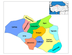
| Province | Çankırı |
| Government | |
| • Mayor | İrfan Dinç (AKP) |
| Area[1] | |
| • District | 1,347.05 km2 (520.10 sq mi) |
| Population (2012)[2] | |
| • Urban | 74,192 |
| • District | 84,225 |
| • District density | 63/km2 (160/sq mi) |
| Website |
www |
.jpg)
Çankırı is the capital city of Çankırı Province, in Turkey, about 140 km (87 mi) northeast of Ankara. It is situated about 800 m (2500 ft) above sea level.
History
Çankırı was known in antiquity as Gangra, and later Germanicopolis (Greek: Γερμανικόπολις. In the writings of the Greco-Roman writer Ptolemy, the city is referred to as Germanopolis (Greek: Γερμανόπολις),[3] then Changra, Kandari or Kanghari.
Over the centuries the settlement witnessed the hegemony of many cultures and races, such as Hittites, Persians, Ancient Greeks, Parthians, Pontic Greeks, Galatians, Romans and Byzantine Greeks, up to the Seljuks and finally the Ottoman Turks. Traces from its long past are still visible throughout the city.
Gangra, the capital of the Paphlagonian kingdom of Deiotarus Philadelphus, son of Castor, was absorbed into the Roman province of Galatia upon his death in 6/5 BC. The earlier town, the name of which signified "she-goat", was built on the hill behind the modern city, on which are the ruins of a late fortress, while the Roman city occupied the site of the modern city. It was named Germanicopolis, after Germanicus or possibly the emperor Claudius, until the time of Caracalla.
In Christian times, Gangra was the metropolitan see of Paphlagonia. Hypatios, considered a saint in the Orthodox tradition, was bishop of Gangra. He was killed by Arians on his return from the Council of Nicaea (325 AD), in which he took part.
In the 4th century, the town was the scene of an important ecclesiastical synod, the Synod of Gangra. There is disagreement about the date of the synod, with dates varying from AD 341 to 376. The synodal letter states that twenty-one bishops assembled to take action concerning Eustathius of Sebaste[4] and his followers, who condemned marriage, disparaged the Offices of the Church, held conventicles of their own, wore a peculiar dress, denounced riches, and affected special sanctity. The synod condemned the Eustathian practices, declaring, however, with remarkable moderation, that it was not virginity that was condemned, but the dishonoring of marriage, not poverty, but the disparagement of honest and benevolent wealth, not asceticism, but spiritual pride, not individual piety, but dishonoring the House of God. The twenty canons of Gangra were declared ecumenical by the Council of Chalcedon in 451.
Climate
Çankırı has a dry summer continental climate (Köppen climate classification Dsa and Dsb) with humid continental climate (Dfa and Dfb) characteristics, since the wettest part of the year is spring and early summer. The province displays all four of these continental climate subtypes depending on location and elevation. The city is located in a transitional region of the province. Summers are usually hot and dry and winters are cold and snowy.
| Climate data for Çankırı | |||||||||||||
|---|---|---|---|---|---|---|---|---|---|---|---|---|---|
| Month | Jan | Feb | Mar | Apr | May | Jun | Jul | Aug | Sep | Oct | Nov | Dec | Year |
| Record high °C (°F) | 15.4 (59.7) |
19.2 (66.6) |
27.8 (82) |
30.6 (87.1) |
34.8 (94.6) |
39.6 (103.3) |
42.4 (108.3) |
41.2 (106.2) |
37.8 (100) |
34.2 (93.6) |
24.4 (75.9) |
17.6 (63.7) |
42.4 (108.3) |
| Average high °C (°F) | 3.4 (38.1) |
5.8 (42.4) |
11.9 (53.4) |
17.7 (63.9) |
22.7 (72.9) |
27.1 (80.8) |
30.9 (87.6) |
30.9 (87.6) |
26.6 (79.9) |
20.1 (68.2) |
12.0 (53.6) |
5.6 (42.1) |
17.89 (64.21) |
| Daily mean °C (°F) | −0.6 (30.9) |
0.9 (33.6) |
5.6 (42.1) |
11.0 (51.8) |
15.7 (60.3) |
19.8 (67.6) |
23.0 (73.4) |
22.4 (72.3) |
17.6 (63.7) |
11.9 (53.4) |
5.6 (42.1) |
1.6 (34.9) |
11.21 (52.17) |
| Average low °C (°F) | −4.2 (24.4) |
−3.3 (26.1) |
−0.2 (31.6) |
4.5 (40.1) |
8.4 (47.1) |
11.7 (53.1) |
14.1 (57.4) |
13.7 (56.7) |
9.4 (48.9) |
5.2 (41.4) |
0.6 (33.1) |
−1.9 (28.6) |
4.83 (40.71) |
| Record low °C (°F) | −24.0 (−11.2) |
−23.9 (−11) |
−20.5 (−4.9) |
−8.9 (16) |
−3.0 (26.6) |
1.6 (34.9) |
4.3 (39.7) |
4.6 (40.3) |
−1.0 (30.2) |
−6.3 (20.7) |
−11.6 (11.1) |
−18.8 (−1.8) |
−24 (−11.2) |
| Average precipitation mm (inches) | 42.3 (1.665) |
34 (1.34) |
36.8 (1.449) |
46.4 (1.827) |
54.4 (2.142) |
38.7 (1.524) |
18.2 (0.717) |
17.6 (0.693) |
16.5 (0.65) |
27.7 (1.091) |
26.8 (1.055) |
47.9 (1.886) |
407.3 (16.039) |
| Avg. rainy days | 11.2 | 9.4 | 8.9 | 12.0 | 13.1 | 10.0 | 5.0 | 4.0 | 4.6 | 7.2 | 8.1 | 10.5 | 104 |
| Mean monthly sunshine hours | 62 | 92.4 | 158.1 | 177 | 241.8 | 282 | 322.4 | 306.9 | 252 | 182.9 | 108 | 52.7 | 2,238.2 |
| Source: Devlet Meteoroloji İşleri Genel Müdürlüğü [5] | |||||||||||||
Economy
Agriculture
Various agricultural produce, including wheat, corn, beans, and apples is grown in the farms and fields.
Industry
Most industry is concentrated near the Çankırı city center and the town of Korgun. Other towns included in the larger industrial area of the city are Şabanözü, Çerkeş, Ilgaz, Kurşunlu, and Yapraklı.
| Wikimedia Commons has media related to Çankırı. |
See also
References
- ↑ "Area of regions (including lakes), km²". Regional Statistics Database. Turkish Statistical Institute. 2002. Retrieved 2013-03-05.
- ↑ "Population of province/district centers and towns/villages by districts - 2012". Address Based Population Registration System (ABPRS) Database. Turkish Statistical Institute. Retrieved 2013-02-27.
- ↑ Ptol., v. 4. § 5
- ↑
 "Eustathius of Sebaste". Catholic Encyclopedia. New York: Robert Appleton Company. 1913.
 - ↑ http://www.dmi.gov.tr/veridegerlendirme/il-ve-ilceler-istatistik.aspx?m=CANKIRI
-
 This article incorporates text from a publication now in the public domain: Chisholm, Hugh, ed. (1911). Encyclopædia Britannica (11th ed.). Cambridge University Press.
Further reading
- Boğaç A. Ergene: Local Court, Provincial Society and Justice in the Ottoman Empire, Legal Practice and Dispute Resolution in Çankırı and Kastamonu (1652-1744). Studies in Islamic Law and Society, volume 17, Brill, Leiden, 2003. ISBN 90-04-12609-0.