Águia Branca
Coordinates: 18°58′58″S 40°44′24″W / 18.98278°S 40.74000°W

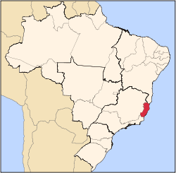
Águia Branca is a municipality in the state of Espírito Santo, in south eastern Brazil. Located in central western Espírito Santo. The municipality has an urban population of just over 2.300, and a rural population of over 7.200, (IBGE, 2000)
History
It was first colonized by Polish immigrants, in 1928. Polish was widely spoken in the region till the Second World War, when the Brazilian government prohibited education in Polish and German.
Geography
Located 226 km from the state capital Vitória. Municipalities it shares borders with include: (west) Mantenópolis and Pancas. (north) Barra de São Francisco and Nova Venécia. (south) São Domingos do Norte. (east) São Gabriel da Palha.
The municipality is in a markedly mountainous region of the state, and Águia Branca town looks up at great finger shaped stone peaks which surround the area. Municipal maximum height is at 878m above sea level.
External links
| |||||||||||||||||||||||||||||||||||||||||||||||||||||||||||||||||||||