Yzerfontein
| Yzerfontein | |
|---|---|
 | |
 Yzerfontein | |
| Coordinates: 33°19′59″S 18°09′43″E / 33.333°S 18.162°ECoordinates: 33°19′59″S 18°09′43″E / 33.333°S 18.162°E | |
| Country | South Africa |
| Province | Western Cape |
| District | West Coast |
| Municipality | Swartland |
| Area[1] | |
| • Total | 6.68 km2 (2.58 sq mi) |
| Population (2011)[1] | |
| • Total | 1,140 |
| • Density | 170/km2 (440/sq mi) |
| Racial makeup (2011)[1] | |
| • Black African | 8.9% |
| • Coloured | 5.6% |
| • Indian/Asian | 0.5% |
| • White | 81.4% |
| • Other | 3.5% |
| First languages (2011)[1] | |
| • Afrikaans | 71.5% |
| • English | 25.3% |
| • Xhosa | 1.2% |
| • Other | 1.9% |
| PO box | 7351 |
| Area code | 022 |
Yzerfontein is a small harbor town with about 1200 inhabitants on the west coast of South Africa about 90 km north of Cape Town. The main sources of income are tourism (especially during the wild flower season from August to October), and fishing.
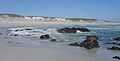
Yzerfontein is known for its unique 16 Mile Beach, the longest uninterrupted sandy beach on the South African coastline, stretching north of the main beach, to the West Coast National Park which borders the town. Dassen Island is about 10 km offshore to the west.
Yzerfontein is the landing point for the ACE and WACS submarine communications cables.
Outside of town is the Darling Wind Farm and it is operational with plans for expansion.
-

Yzerfontein in 2006
-

Beach at Yzerfontein
-
Pearl Bay suburb, a new development in the south of Yzerfontein
References
- ↑ 1.0 1.1 1.2 1.3 "Main Place Yzerfontein". Census 2011.
External links
| |||||||||||||||||||||||
.svg.png)